Underwater volcano captured off the coast of Tongatapu

Today’s Image of the Day features an underwater volcanic eruption just off the coast of Tongatapu.
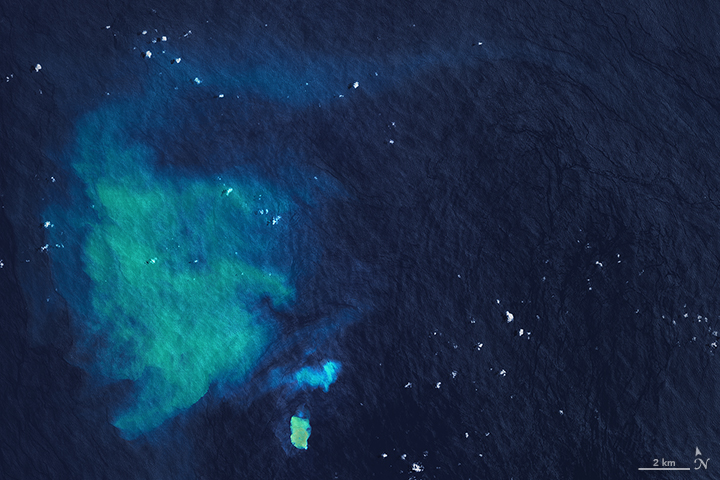
The eruption was first noticed by Murray Ford, a coastal geologist from the University of Auckland as he was reviewing satellite images of the nearby island Hunga Tonga-Hunga Ha’apai. In the corner of one image, he noticed a turquoise plume of water. Murray quickly realized the plume was coming out of a seamount just 20 miles off the coast of Tongatapu, the main island of the Kingdom of Tonga in the Pacific Ocean.
The water discoloration is most likely the result of volcanic gases, rocks, and fluids being released underwater. The eruption may also have broken off pieces of sediment from the seamount, which scientists call the Submarine Volcano II. This particular underwater volcano has shown signs of activity in 1911, 1923, 1970, 1990, and 2007.
The images were taken by NASA’s Operational Land Imager on Landsat 8 January 27th, 2017.
“It may continue for some days or weeks, and an island may form temporarily,” said University of Tasmania geologist Martin Jutzeler. “However, new volcanic islands are easily eroded by wave action.”
Underwater eruptions occur somewhat frequently in this region. The area is known as the Tonga-Kermadec volcanic arc, a piece of the Pacific Ring of Fire. Most volcanoes in the Tonga-Kermadec arc produce hydrothermal activity, during which hot seawater containing dissolved volcanic rock is released into the ocean.
Just in the way that land eruptions can cause hazards for airplanes, underwater eruptions can pose a threat to ships. Many underwater eruptions release pieces of pumice rock that can clog the engines of ships.
—
By Rory Arnold, Earth.com Staff Writer
Source: NASA Earth Observatory


