NASA and the FAA are preparing drones to fight fires at night and in deadly conditions
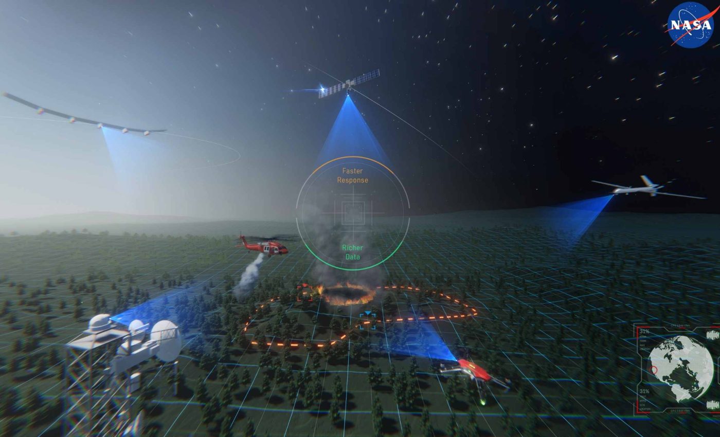
NASA and the FAA, using new technology called ACERO, are preparing drones and uncrewed aircraft to fight wildfires during the day, but also at night and in smoky conditions. It is designed for use during real incidents, not only training.
The plan relies on a portable system that manages wildfire airspace so aircraft stay safely separated. It aims to keep firefighters and pilots safer when smoke thins visibility.
ACERO cutting-edge tech

Dr. Min Xue of NASA’s Ames Research Center is leading work on a portable airspace manager that crews can carry into the field. The system is built for chaotic fire scenes where visibility drops and radio contact can be spotty.
“We need every advantage possible when it comes to saving lives and property when wildfires affect our communities, and ACERO technology will give responders critical new tools to monitor and fight fires,” said Carol Carroll, deputy associate administrator for NASA’s Aeronautics Research Mission Directorate. Her remarks strongly stress saving lives.
In 2024, NASA and the FAA formed a research transition team to guide uncrewed fire operations from the lab into daily use. The group will shape tests and share results.
The uncrewed aircraft, aircraft flown without people on board and controlled remotely, can stay out of dangerous conditions that ground piloted planes. They also let firefighters focus on tactics rather than flying.
Nighttime and smoky flights matter
Current aerial firefighting pauses when smoke hides ridgelines and other aircraft. That pause costs time and options during fast moving burns.
The portable system aims to extend safe flights through thick smoke and after dark by giving pilots a live picture of who is flying where. It also keeps a record of approved routes so crews avoid midair conflicts.
Temporary flight restrictions don’t always prevent overlap in complex fire zones, but tracking tools that display aircraft clearances can fill those gaps.
More flight hours mean pilots can scout heat at first light and hold lines until crews arrive. Added night coverage also helps with logistics and perimeter checks during long shifts.
How ACERO and PAMS work
The core tool is the Portable Airspace Management System (PAMS), a suitcase size kit that links pilots and incident staff. It shows aircraft positions, intended routes, and alerts when a drone wanders off its assigned path.
PAMS uses a shared traffic picture to boost situational awareness. When a route drift or boundary crossing is detected, the system flags it and helps pilots return to their planned track.
A NASA paper describes how PAMS grew out of earlier UAS traffic management research and was tailored for fire missions. It outlines strategic coordination, conformance checks, and communication links suited to hills, valleys, and weak cell coverage.
The conformance monitoring, alerts when a flight strays from its plan, helps incident staff catch small errors before they become big risks. It also builds a record that can be reviewed after each shift.
March ACERO test results
In March 2025, NASA staged multi day tests in the Sierra de Salinas foothills of Monterey County, California. Crews placed units on different sides of the range, then flew drones as if supporting a live fire.
Using a radio relay from a larger aircraft, the units exchanged a simulated fire zone, aircraft locations, and detailed flight intent. The test team also coordinated with a remotely piloted aircraft similar in size to a small commuter plane.
“These tests were successful, providing valuable insights and highlighting areas for future improvement,” said Dr. Xue. That success paved the way for broader trials.
A technical overview confirms the Salinas evaluation, and details how the interface supported planning and conformance monitoring. It also describes questionnaire results from pilots who used the tool in the field.
Safety and policy questions
The system reduces risk, but it does not erase it. Drones must still steer clear of retardant drops, crewed helicopters, and temporary flight restrictions set up over incidents.
Low visibility adds workload, so training and clear roles matter. The ground “air boss” model shifts to a digital picture that must be reliable when power or backhaul links fail.
Sustained night operations require rules for beyond visual line of sight flights, the ability to fly when the pilot cannot see the aircraft. Federal regulators have proposed a framework that would open a path to these missions.
Another hurdle is data sharing across agencies that use different radios and software. If the tool is easy to use and adds useful warnings without clogging radios, crews will reach for it.
ACERO, PAMS, and the future
NASA’s goal is to prove the system, then hand it to public and private partners who will deploy it during active seasons. Feedback from agencies will guide which features get refined first.
Field data will drive updates to information sharing, alert logic, and displays that are easier to read through smoke and long nights. The objective is simple, more safe flight hours when crews need them most.
“This testing will provide valuable data to inform how we mature this technology for eventual use in the field,” said Dr. Xue. It also helps planners decide which features to prioritize.
NASA and the FAA will continue joint work so the technology and procedures fit smoothly with incident command. That includes developing a concept of operations that keeps people safe while adding new air tools.
—–
Like what you read? Subscribe to our newsletter for engaging articles, exclusive content, and the latest updates.
Check us out on EarthSnap, a free app brought to you by Eric Ralls and Earth.com.
—–


