
Scientists are struggling to explain the purpose of these 5,000 dirt pits dug into a hillside in Peru
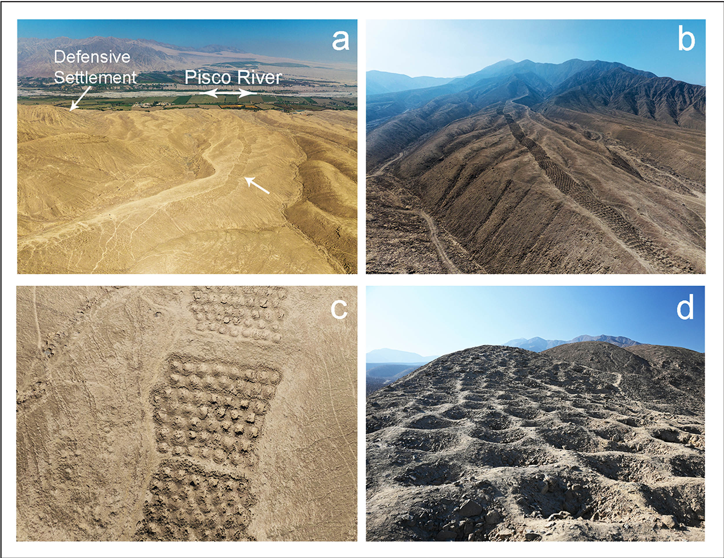
A strange hillside in southern Peru – a region known as Monte Sierpe – has puzzled archaeologists for decades, its surface carved with more than 5,000 perfectly aligned pits that stretch nearly a mile.
A new peer-reviewed study now argues that this formation, also known as the “Band of Holes,” may have once served as a vast open-air market and later as an accounting site under Inca rule.

Set in the Pisco Valley, researchers used drone mapping and microscopic plant analysis to piece together how the site evolved over time.
Their findings suggest the pits first supported trade and exchange among local groups, then later became a tool for tallying goods and labor as imperial systems of control expanded.
Monte Sierpe pits formed a pattern
The work was led by Jacob L. Bongers, a digital archaeologist at the University of Sydney. His research focuses on Indigenous accounting, Andean landscapes, and how people used built spaces to manage resources.
Monte Sierpe runs for about 0.9 miles (1.4 kilometers) along a ridge, with its pits grouped into blocks separated by walkways.
Many pits are up to 6.5 feet (2 meters) wide and roughly 3.3 feet (1 meter) deep, and the band remains easy to cross from section to section.
Sections differ in size and internal counts, which matters for how people may have used them. The grouping suggests that people could move along the sides, deposit items, and then compare amounts across neighboring blocks.
Clues buried in Monte Sierpe pits
Researchers analyzed tiny plant traces called microbotanicals – small remains such as pollen or starch, from sediment sampled inside the pits at Monte Sierpe. They found maize, reeds, and other plants linked to packaging and transport.
Maize fits everyday exchange, while reed and bulrush pollen match basketry used across the coast for carrying goods. The mix points to people placing plant materials into pits rather than the pits collecting plants by chance.
“Examining the imagery revealed intriguing numerical patterns in layout,” said Bongers. Drone surveys revealed repeated counts, including runs of equal rows and alternating numbers that look intentional.
Those counts echo the logic of khipus – knotted cord systems for counting and recordkeeping. A khipu from the same valley shows grouped cords with repeating values, a close match to how the hillside band clusters pits by section.
Andes’ natural marketplace
Monte Sierpe sits in the Chaupiyunga, a mid-elevation zone between the coast and highlands of Peru. That location is ideal for people from fishing and farming zones to meet at a crossroads and trade goods without traveling far.
The region supported a large pre Hispanic population, on the order of about 100,000 people during the Late Intermediate Period (LIP). Surplus from intensive farming and fishing makes regular barter plausible, with public exchange ensuring fair dealings.
When the Inca expanded, they reorganized communities and used the mit’a, a rotating labor tax required by the state. That system relied on tallies of work and produce, and it favored simple, visible ways to count contributions.
Archaeologists have documented floor grids and cord records at the Inca storehouse of Inkawasi that likely standardized measured portions. That study shows how accounting could be anchored to marked spaces and matched with knotted records.
Rival explanations for Monte Sierpe
Alternative ideas, like fog capture, defense, or mining, fit the setting less well when checked against the numbers and plant remains. The distribution of maize and basketry plants points to people hauling goods, not to gardens or fortifications.
The soil also preserves phytoliths – microscopic silica bodies left by plants – which support deliberate placement of plant materials in the pits. That pattern lines up with periodic exchange, where each pit stands in for a known portion.

Linking pits to history
A charcoal sample from one pit dates to the 1300s by radiocarbon dating, a method that estimates age from carbon decay in once-living matter. That timing matches nearby settlements from the same period and Inca-era use afterward.
The study’s mapping also shows around sixty sections separated by narrow crosswalks. This layout makes crowd management and portion control easier – which is exactly what a busy fair or tax checkpoint would need.
Questions remain about Monte Sierpe
The strongest thread runs from counted pits to counted cords. Both systems group units, repeat specific totals, and track differences between adjacent sets – a plain recipe for inventories, distributions, or audits.
“Our findings are unexpected and carry implications for better understanding accounting, exchange, and resource management within and beyond the Andes,” said Bongers. “This idea remains tentative.” That fit is suggestive, not proof of any single script.
Caution is warranted, and the authors say so. Researchers still do not know why this form appears here and not elsewhere across the Andes. They also want to test how sections map onto nearby communities that may have shared routes, water, or fields.
Photo credit: Jacob L. Bongers
The study is published in Antiquity.
—–
Like what you read? Subscribe to our newsletter for engaging articles, exclusive content, and the latest updates.
Check us out on EarthSnap, a free app brought to you by Eric Ralls and Earth.com.
—–


