Scientists discover that underwater canyons are not formed by rivers
A global study examined more than 2,000 underwater canyons and found that the steepness of the seafloor best predicts where they form. The work was carried out by a German research team working along continental margins worldwide.
The work was led by Anne Bernhardt, PhD, at Freie Universität Berlin. Her research focuses on how Earth’s coasts and continental edges evolve over geologic time.

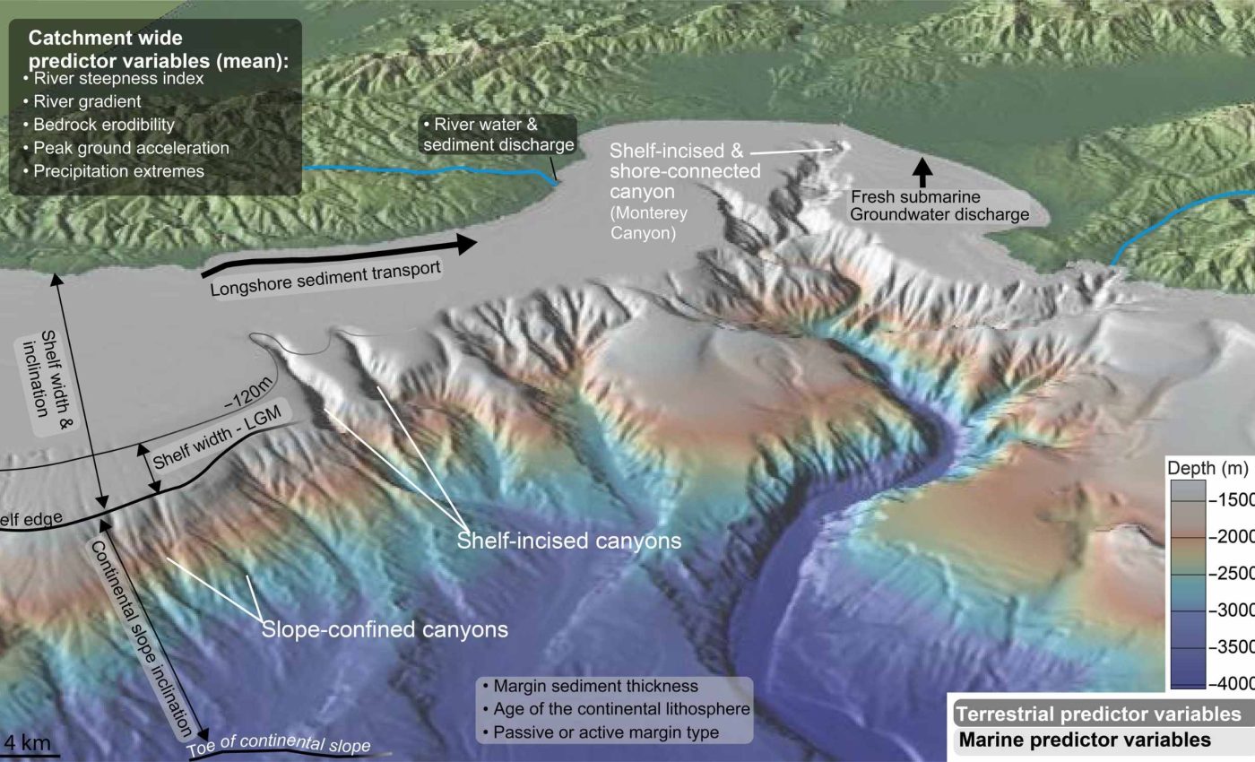
A submarine canyon, a deep underwater valley cut into the continental edge, funnels sediment and carbon toward the deep ocean. The new results show these canyons prefer steep slopes and do not need a river sitting right above them.
“Our analysis shows that tectonic and thermal processes shaping the ocean floor ultimately determine where canyons form, and these deep underwater valleys act as major routes carrying sediment and carbon into the deep sea, influencing Earth’s climate over geologic time scales,” said Bernhardt.
The team also reports a competitive twist. Once a canyon gains access to coastal sediment, it can capture more material than neighbors and grow faster.
Submarine canyons and slope
The continental slope – the seafloor that drops from the shallow shelf into deep water – is shaped by plate motion, cooling crust, and sediment build up or loss. Where that slope is steep, gravity helps erosion get started and keep going.
Steep slopes are prone to landslides and slumps. That instability, a tendency for slopes to fail under their own weight, can initiate canyon heads that later cut farther upslope.
Fast moving turbidity currents, dense clouds of sand and mud that rush downslope under gravity, are common in and around canyons.
A recent review estimates these flows bury about 62 to 90 million tons of terrestrial carbon in marine sediments each year.
This burial is not uniform. Where canyons are numerous and steep, the capacity to route and store carbon rises, especially when canyon heads link to coastal sediment sources.
Rivers and submarine canyons
Canyons do not need rivers to begin, but rivers can strengthen them later. When a canyon cuts back into the continental shelf, sediment arriving from rivers or longshore currents can keep it active.
During glacial lowstand, a time when global sea level fell and shorelines moved seaward, more rivers likely touched canyon heads. That connection increased the amount of sediment reaching the deep sea.
Earlier research found that shore connected canyons tend to occur where shelves are narrow and steep. Bedrock durability and high river discharge also matter because they supply coarse sediment that helps canyons erode.
When sea level rose again, many of those links were lost. Even so, the canyons that kept their link continued to ship sediment and carbon offshore.
Testing this theory
The team used point pattern analysis, a statistical method that checks whether locations cluster more than random chance, to evaluate canyon positions along continental slopes.
They treated each canyon as a point and asked which environmental variables best explain where those points occur.
They compared 16 predictors, measured factors that might explain canyon locations, including slope steepness, shelf width, earthquake shaking, sediment thickness, and more.
Model selection relied on the Akaike Information Criterion, a score that weighs fit and simplicity to favor the most informative model.
Steepness of the seafloor stood out as the strongest predictor for both slope confined canyons and shelf incised canyons. Shelf steepness also helped explain which canyons erode into the shelf and approach the coast.
To check whether canyons tend to cluster beyond what the model predicts, the team tested residual patterns with a Poisson process – a math model for random points in space.
These tests suggest that once a canyon reaches the shelf, it can suppress nearby rivals by intercepting more sediment.
Why this matters now
Submarine canyons move and bury organic carbon in the deep sea. That long term burial makes the seafloor a carbon sink, a place that stores more carbon than it releases, which helps regulate climate over long timescales.
Better knowledge of where canyons form can improve Earth system models. It can also guide surveys toward places where carbon likely reaches deep water most efficiently.
“These processes unfold over immense geological time scales and are difficult to observe because they occur far beneath the ocean surface, which is why we used a statistical model to better understand how submarine canyons form through global data,” said Wolfgang Schwanghart, from the Institute of Environmental Science and Geography at the University of Potsdam.
The findings also matter for hazards and infrastructure. Rapid sediment flows inside canyons can damage seafloor cables and pipelines, which makes accurate canyon maps and monitoring more important.
The study is published in Science Advances.
—–
Like what you read? Subscribe to our newsletter for engaging articles, exclusive content, and the latest updates.
Check us out on EarthSnap, a free app brought to you by Eric Ralls and Earth.com.
—–


