Earth's "atmospheric rivers" have shifted, causing big weather changes
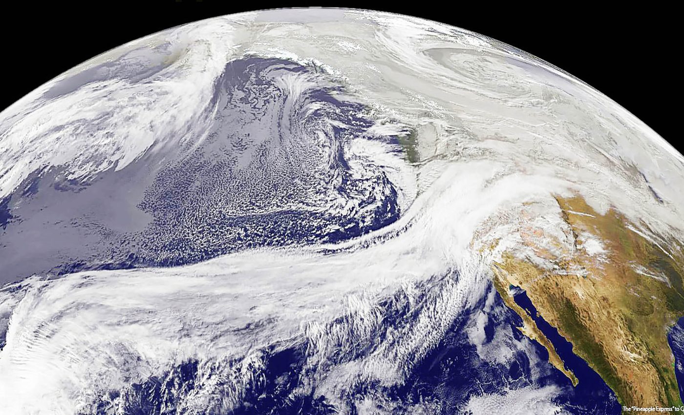
Right now, above your head, narrow bands of moisture flow through the air. These “atmospheric rivers” can carry more water than the Amazon River. The difference is that they contain water vapor, not liquid water.
When these atmospheric rivers reach land and slow down, a key process occurs. The vapor condenses into clouds and can release large amounts of rain or snow.

One strong atmospheric river can bury the Sierra Nevada mountain range in several feet of snow. It can rapidly refill depleted reservoirs, but will also cause floods that damage or destroy neighborhoods.
Shifting paths of atmospheric rivers
Scientists at the University of California, Santa Barbara (UCSB), report that these atmospheric rivers are no longer traveling along their historical paths. They are shifting toward both poles, a change that was not anticipated.
Zhe Li recently completed his doctorate in atmospheric circulation at USCB. He worked with his advisor, Qinghua Ding, to track these atmospheric rivers.
“Atmospheric rivers are shifting poleward in both hemispheres,” Li said, “bringing heavy rain and storms to higher latitudes, which could reshape precipitation patterns globally.”
Climate models predicted many changes related to global warming, but not this specific shift in storm paths.
This is a major concern for researchers around the world, so Li and Ding decided to investigate the cause of the shift.
Tracking invisible sky rivers
The scientists reconstructed past atmospheric conditions using data from the European Centre for Medium-Range Weather Forecasts, ERA5.
They compiled historical measurements from satellites, weather balloons, and ground stations dating back to 1979.
They assimilated the data into models that filled observational gaps and produced hour-by-hour atmospheric analyses.
They identified atmospheric rivers by detecting corridors with exceptionally high water vapor transport.
After analyzing about 40 years of data, they found a notable change: these rivers have moved several degrees of latitude toward the poles.
In practical terms, the storm tracks have shifted roughly the distance between Los Angeles and San Francisco.
Unexpected findings
Most of their colleagues expected human-caused climate warming to be the primary driver of this atmospheric river shift.
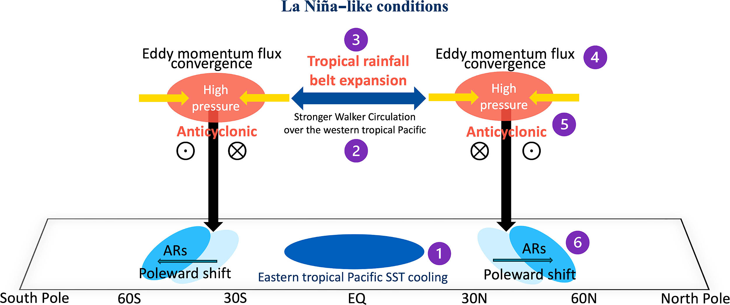
However, the evidence suggests ocean conditions are a primary driver. Variations in sea surface temperatures in the tropical eastern Pacific appear to influence where these rivers flow.
“Based on that, we hypothesize that this observed shift is not totally due to anthropogenic forcing,” Ding explained.
The researchers propose that much of the observed shift reflects natural variability rather than direct human forcing.
Why weather storms shift
The planet is warming, but not evenly – some regions warm faster than others. This uneven warming alters the large-scale wind patterns that steer storms.
The jet streams that steer weather are shifting toward the poles. Atmospheric rivers are guided by these jet streams. When the jet streams move, the rivers tend to follow.
This shift is already causing practical problems.
Places that used to receive regular winter rain from atmospheric rivers now face drought. Meanwhile, higher-latitude areas experience storms that were previously uncommon.
Local weather and atmospheric rivers
Many regions depend on three or four atmospheric rivers each winter for most of their annual water supply. If those rivers shift north or south, communities may face severe water shortages.
Reservoirs may not fill, mountain snowpack may not accumulate, and annual water supplies can decline sharply.
At the same time, towns that have rarely experienced atmospheric rivers can be struck by intense events.
Their drainage systems may be undersized, and existing flood maps may be inaccurate. Homes can flood because these large storms were not anticipated in planning.
Two processes compound the risk. First, warmer air holds more water vapor, so atmospheric rivers can carry more moisture.
Second, their typical routes are changing. Some regions receive fewer storms, but those events are more intense when they occur. Other regions experience storms much more frequently than before.
Timing also matters. Warmer storms tend to drop rain instead of snow.
Rain can cause immediate flooding while snow acts like a reservoir, storing water for spring and summer. Loss of snowpack can reduce summer water supplies.
Rolling with the changes
Past weather patterns are no longer reliable for future planning.
Reservoirs designed to capture January storms might remain underfilled if storms arrive in February or track farther north.
Flood zones based on older maps may not align with current flood locations, so communities need updated plans.
Some require stronger flood protection, while others must expand water conservation and storage capacity. All communities need improved warning systems for atmospheric rivers.
Atmospheric rivers and weather forecasts
This poleward shift is not catastrophic, but it is consequential. Storm tracks have moved hundreds of miles in about 40 years – fast enough to disrupt water supplies, agriculture, and urban planning.
The research suggests these atmospheric rivers may continue to shift, and because of this, communities should pay close attention.
Existing infrastructure may not be adequate for future storm patterns, and water management agreements based on historical averages may no longer be reliable.
The essential step is to determine your local risk and prepare accordingly. The weather map has changed, and planning should change with it.
The full study was published in the journal Science Advances.
—–
Like what you read? Subscribe to our newsletter for engaging articles, exclusive content, and the latest updates.
Check us out on EarthSnap, a free app brought to you by Eric Ralls and Earth.com.
—–


