Study shows how rocks 'breathe' and erode, slowing shaping Earth's landscape
Mountains rise, plains spread, and cliffs retreat. A new study reports that the strength of the rock itself can swing erosion rates by a factor of 20 along a 125 mile stretch in southern Brazil.
The team chose this coast because climate and tectonics are steady there. That calm backdrop lets them isolate how rock type alone steers the pace of change.
Rock strength and erosion

Geologists use the word lithology, the kind of rock and how it is put together, to explain why some slopes crumble while others hold fast. Hard volcanic rocks resist tools and storms, while weaker sandstones give way more easily.
The work was led by Lindsay Schoenbohm, PhD, at the University of Toronto Mississauga. Her research focuses on tectonic geomorphology, the long dance between moving crust, climate, and surface processes.
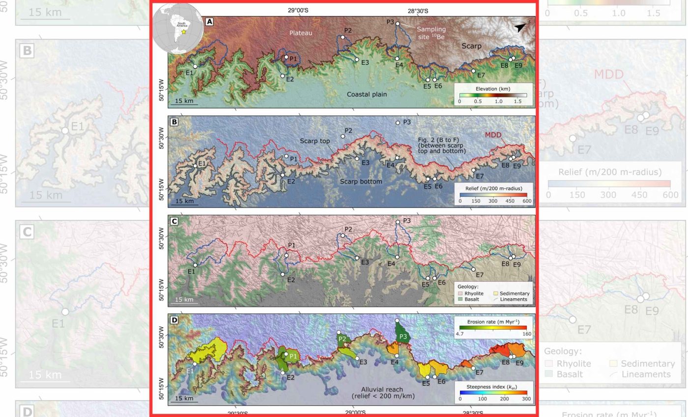
To test the link between rock and erosion, the team started with direct field measurements of toughness. They used a Schmidt hammer, a spring driven device that bounces off a surface to estimate how strong it is, and they repeated tests thousands of times on different rock layers.
They also measured erosion from the grains washing out of each basin. For that they turned to cosmogenic 10Be, a rare isotope made when cosmic rays strike minerals near Earth’s surface, which accumulates over thousands to millions of years, a rate clock for natural sand.
The physics of these nuclides shows how exposure and erosion set the signal.
What the team measured
The transect runs from a high plateau to a steep escarpment that drains to the Atlantic. Rock layers flip from strong volcanic flows above to weaker sedimentary beds below, creating natural test sections.
Where strong lavas dominate, rivers cut slowly. Where weaker rocks take over, channels and hillsides wear much faster, and the whole escarpment steps back.
Field strength data, averaged by watershed, lined up with the erosion rate from the beryllium signal. The stronger the rocks, the lower the wear rate, once you hold climate and base level steady.
Rock erosion forecasts
Many landscape models lean on the stream power law, a simple rule that links river slope, flow, and rock erodibility, to estimate how fast channels cut down.
An analysis showed that climate differences alone can scramble the usual slope to erosion relationship.
This new field test shows that erodibility, a rock’s inherent ease of wear, can do the same. In the Brazil section, two basins with similar slopes can march at very different speeds because their bedrock strength is not the same.
That matters for reading the past and projecting the future. If a map ignores lithology, an inversion that tries to infer uplift history from topography can miss the mark and misread the signal.
It also refines hazard thinking. When weak layers crop out beneath a cliff of tough flows, the escarpment can retreat unevenly, changing where rockfalls and channel shifts may occur over long times.
A new data resource
The group did not stop at one field area. They compiled thousands of rock strength readings into Thor, a public database that organizes Schmidt hammer values by rock type and setting.
Thor helps researchers avoid a common pitfall. Borrowing a single textbook strength for a rock class can be misleading because real outcrops vary widely in cement, fractures, and texture.
With Thor, a scientist can anchor a model in measurements that better match the rocks on the ground. That improves predictions without adding complex new physics.
It also opens the door to fairer comparisons across regions. Two catchments with the same slopes might still erode differently if one traverses strong rhyolite and the other crosses fine grained sandstone.
What “cosmogenic” adds to the picture
Beryllium based clocks read slow change that humans cannot watch directly. A sample of quartz sand, etched and analyzed in a lab, can reveal how fast the upstream hills lost material over long spans.
Because isotopes, atoms of the same element with different mass, build up while surfaces sit near the sky, their concentration tells you how long grains waited before they were carried away. That is why these tools shine in stable settings.
These methods have matured over decades. They bridge gaps between geologic snapshots from fossils or ash layers and short records from sensors and surveys.
When paired with field strength tests, they allow a clean test of cause and effect. Climate, slopes, and rock type can be separated instead of lumped together.
Why it matters beyond Brazil
Most continental crust today is quiet, with little active uplift and broad areas of mixed rocks. In those settings, lithologic heterogeneity, patchy differences in rock strength across a landscape, can drive complex erosion patterns without any help from climate swings.
That makes global maps of erosion more than just a climate story. Rock type steers where rivers will carve, where divides migrate, and which ridges persist.
It also affects how fast landscapes respond to past tectonic pulses. Tough rocks can hold relief for a very long time, while weak layers speed smoothing and sediment delivery to coasts.
Accounting for strength helps land managers, hazard planners, and modelers focus on the right knobs. It directs limited field time to the layers that matter most for long term change.
The study is published in Science Advances.
—–
Like what you read? Subscribe to our newsletter for engaging articles, exclusive content, and the latest updates.
Check us out on EarthSnap, a free app brought to you by Eric Ralls and Earth.com.
—–


