
Scientists trace the origin of water streams at the top of mountains
High mountain streams look calm from a distance, but they carry the first drops that feed major rivers.
In places like the Rockies, these headwater channels make up more than 70 percent of the river network. They keep downstream towns supplied with water and support fish, insects, and plants that depend on steady flow.

Most people never see these small streams up close, and even scientists struggle to keep track of them. Many are not monitored at all, and the way water moves through them is still a puzzle.
Every spring, snowmelt sends a rush of water downhill. Once summer heat kicks in, most rainfall in the Western United States never reaches the streams. It evaporates or gets taken up by thirsty vegetation.
That raises a basic question. After the spring flush ends, what keeps these mountain streams running?
Why hidden water matters
Only after looking deeper do we learn that a key part of the story sits underground.
A team of researchers, including Lijing Wang, an assistant professor from the University of Connecticut’s Department of Earth Sciences, set out to figure out how water is stored beneath the surface and how it moves long after snowmelt fades.
“We know it is coming from the hidden source, the subsurface,” Wang said. “But how is that subsurface water stored and released? What properties are important for sustaining late season water in headwater streams?”
Communities depend on steady water coming from these mountains, especially as climate change pushes snow patterns to shift and summer heat to intensify.
Without solid details on snowmelt timing and subsurface contributions, it becomes tough to predict how much water ecosystems and people downstream can expect in any given year.
What the team studied
The group looked at two major influences. One was the vegetation above ground, which affects how long snow stays on the ground. The other was the structure of the soil and rock below, which determines how water is stored and released later.
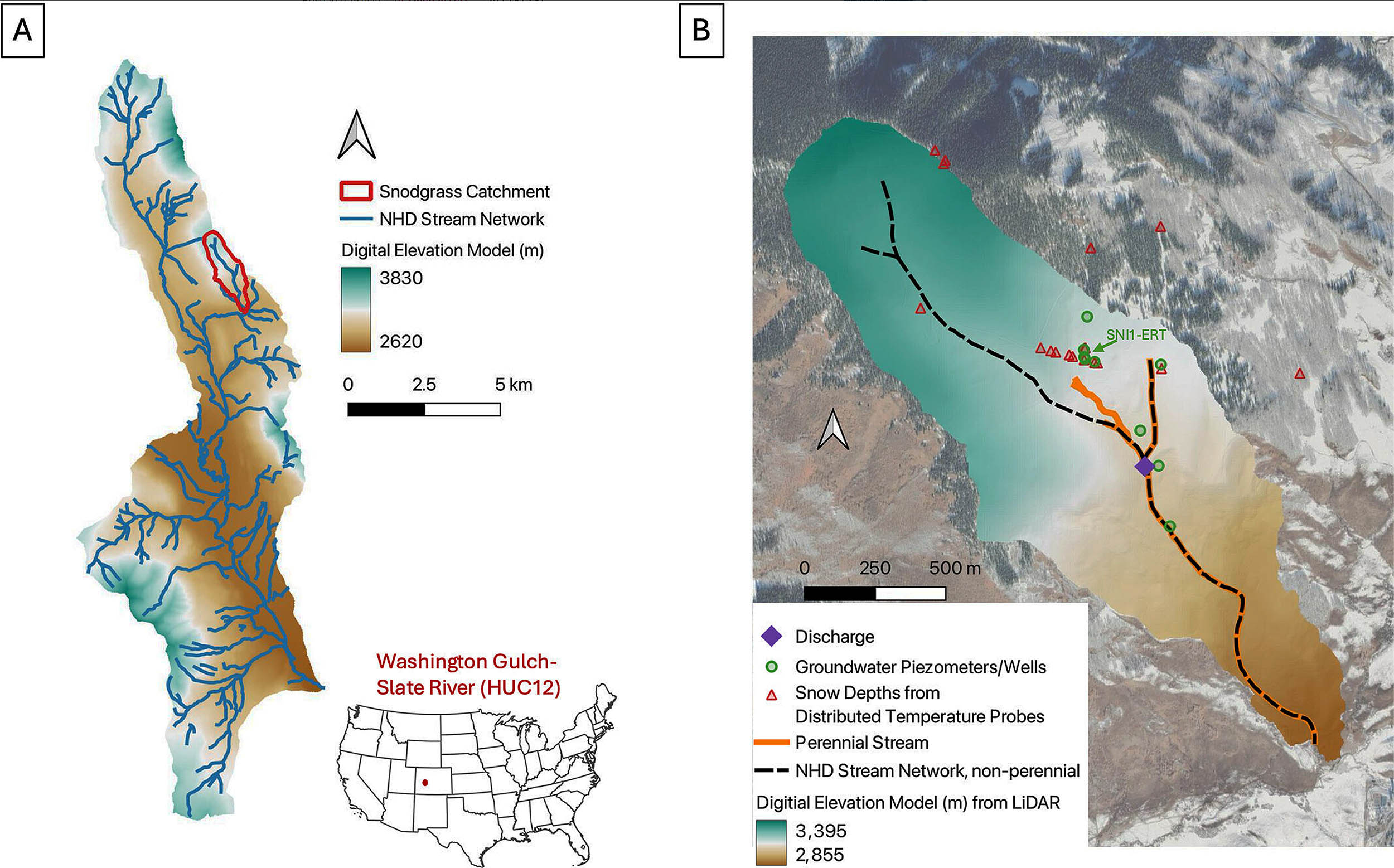
The team had access to a rare, detailed data set gathered by the Watershed Function Science Focus Area led by Lawrence Berkeley National Laboratory (LBL).
The researchers combined this data with a modeling framework that let them test many possible scenarios.
Next, they adjusted the model until it produced results that matched real measurements of streamflow, groundwater levels, and snow depths.
“We have unique snow depth measurements using probes with multiple temperature sensors stacked vertically at 18 sites across our catchment,” Wang said.
“Because snow is a good insulator, the changes in vertically resolved temperature datasets can be used to trace snow depth and understand snowmelt timing.”
Snow, trees, and mountain streams
The team found that vegetation around mountain streams mattered. Snow melted one to two weeks later in areas that had evergreens compared to shrubs, grass, or deciduous forests at the same elevation.
According to the model, evergreen forests also slow the release of water from the melting snowpack. They act as a buffer that stretches out streamflow instead of sending it all surging downhill at once. Wang noted that clearing these forests could upset this natural balance.
As the season moved past snowmelt, something unexpected showed up in groundwater data.
“We saw not only one peak in the groundwater table, where the snowmelt gives the largest recharge to the groundwater and it will create a peak,” she explained. “Later in the season, we saw a very interesting second peak in our monitored wells.”
Two peaks in downhill water flow
To understand this unusual second bump, the team tested variations in porosity, permeability, and subsurface structures.
“This brought us closer to understanding this site. We have granodiorite on the top, and then the Mancos shale below on this hillslope,” Wang said.
“There is a transition from the upper hillslope to the lower hillslope and the transition delays the water.”
“It is like a bathtub on the upper hillslope; snowmelt fills it, once it builds too much pressure and overflows, the transition can no longer hold water. The second peak is the result of the water that spills out.”
Underground flow shapes streams
Then comes the key part of the story. What controls the flow that reaches the stream later in the season?
“Even if the water is stored there, it’s not going to go anywhere if your permeability is very, very low. The downstream streamflow later in the season will be very low if the upstream contribution from subsurface is blocked by this low permeability,” Wang explained.
The shift from spring surge to late season trickle depends on how snowmelt releases water, how long it stays in underground pockets, and how easily it can move through the soil and rock.
These findings let hydrologists fine-tune their models for better predictions of water availability.
Lessons from mountain streams
The team now has a clearer picture of how groundwater storage and snowmelt work together in these headwater streams.
This kind of information helps reduce uncertainty as experts track declining streamflow and rising water temperatures across the West.
Wang’s ongoing work includes improving the model so it can be used in places without heavy monitoring. She is also testing how AI might cut the cost of running these detailed simulations.
“It is a tremendous effort to put all of this together,” she said. “As a modeler, I’m grateful to have collaborators who make this kind of data possible.”
“We have so many headwater streams across the U.S., it’s not possible for us to go into every single location and do this comprehensive, intensive monitoring. We need new ways to move forward and make better predictions of these critical water sources.”
The full study was published in the journal Water Resources Research.
—–
Like what you read? Subscribe to our newsletter for engaging articles, exclusive content, and the latest updates.
Check us out on EarthSnap, a free app brought to you by Eric Ralls and Earth.com.
—–


