Thawing permafrost in the Arctic is exploding, creating massive craters, and now scientists know why
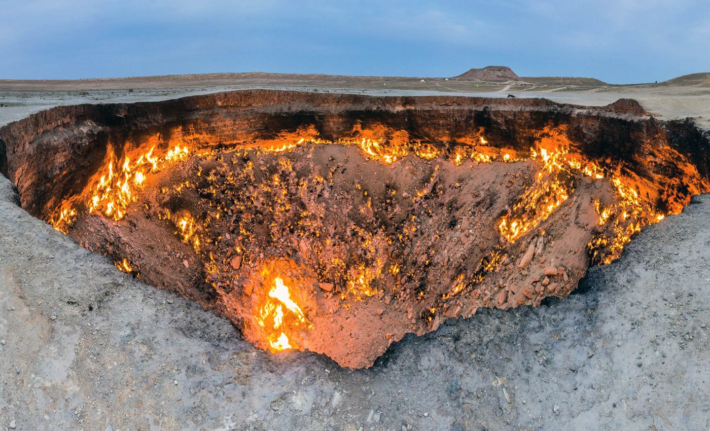
In western Siberia, a rare kind of gas explosion is carving deep, near vertical craters in the tundra. Some of these massive craters exceed 150 feet in depth, as documented in a peer reviewed article.
A new study argues that specific geology, underground gas, and regional Arctic warming caused by climate change all work together to create the “perfect storm” for this new type of natural disaster.

The result is a sudden release of pressure that ejects soil and ice and leaves a steep sided shaft that later fills with water.
Permafrost, gas, and craters
The work was led by Helge Hellevang at the University of Oslo. His team reviewed reports and built a model to test which factors actually match what satellites and field crews have seen.
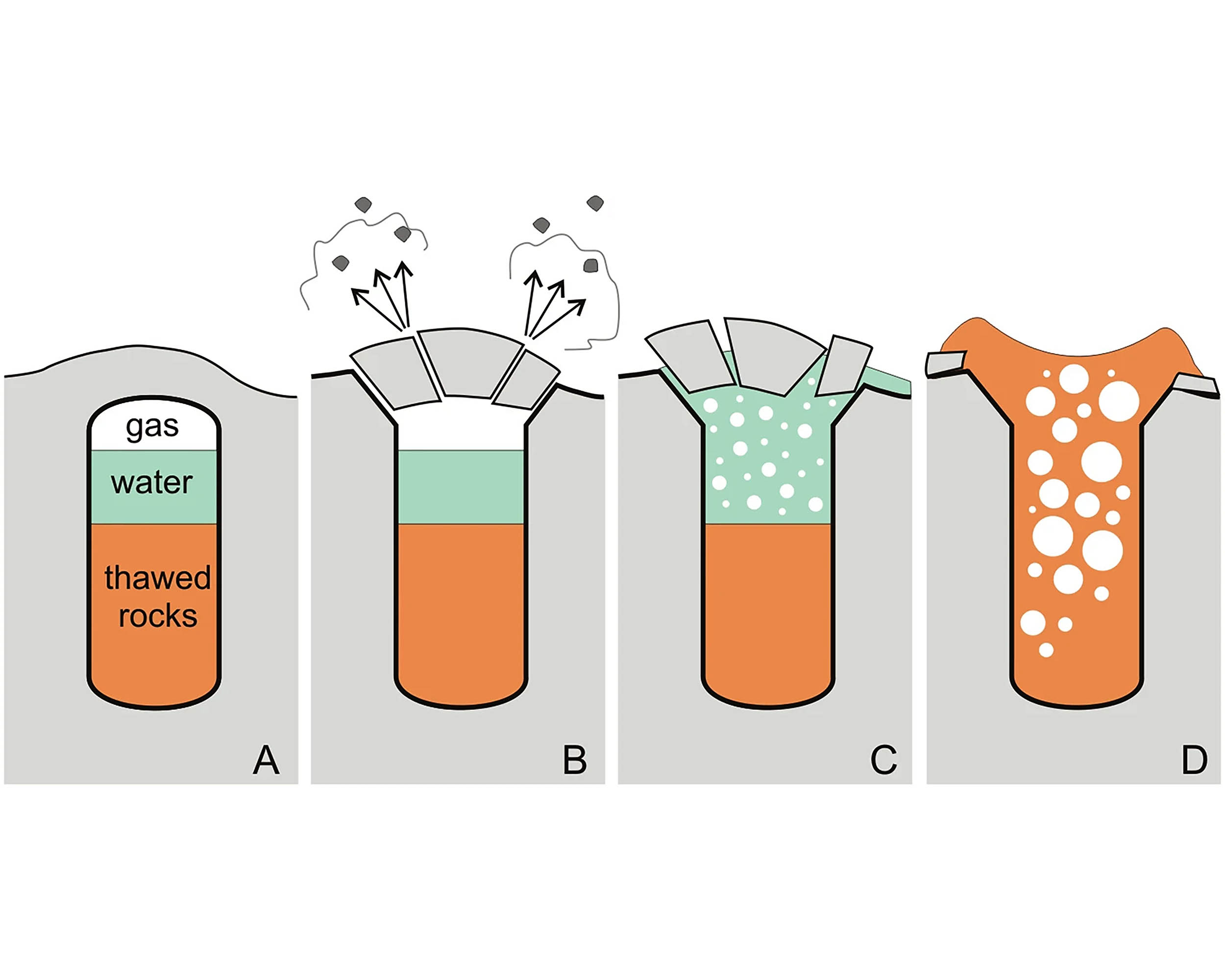
Permafrost is ground that stays frozen for at least two years. It behaves like a stiff, cold layer that can slow gas escape from deeper rock.
The gas in question is mostly methane, a heat trapping molecule that can accumulate when the overlying frozen layer is thick and intact. When that layer warms or thins, gas pathways open and pressure can rise.
Temperatures in parts of western Siberia have climbed in recent decades. That warming increases the rate of thaw at the surface and favors the formation of shallow ponds and lakes that further weaken the frozen cover.
How permafrost gas makes craters
The model points to rising heat and gas migrating upward along a fault, a fracture in rock that can act as a conduit.
If a sealed cavity exists beneath the frozen ground, pressure can build until it exceeds what the overlying material can withstand.
Thaw at the surface may also create a talik, an unfrozen zone under a lake or river that thins the permafrost locally. A thin seal over a cavity is weaker, so less additional pressure is needed to fail.
Observations back up the idea that these are not small puffs of gas.
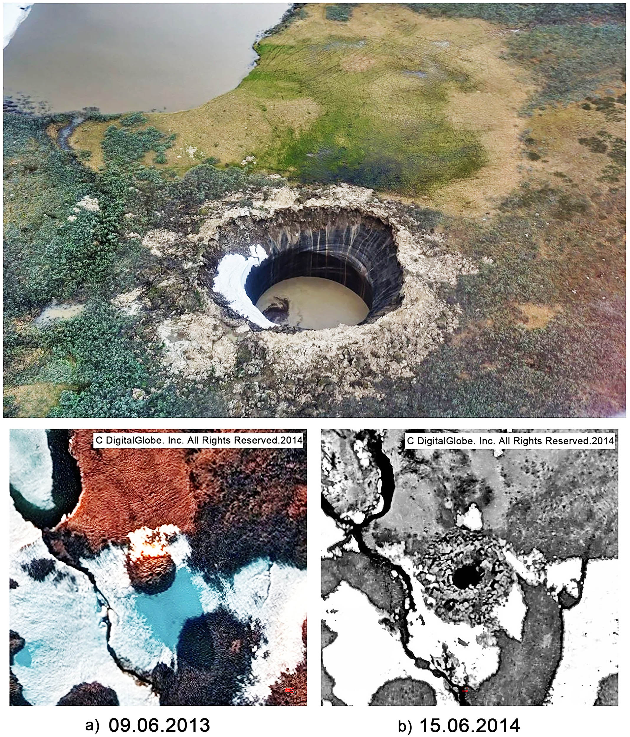
Continuous monitoring at the Seyakha crater recorded sustained methane release for years after a 2017 blowout that also ignited briefly.
Ejecta patterns around known craters show debris thrown outward hundreds of feet, which matches a high pressure event rather than slow seepage.
The near vertical walls at first discovery also point to a sudden failure rather than gradual subsidence.
Why Siberia has so many gas craters
Crater sites cluster on the Yamal and Gydan peninsulas that sit atop one of the world’s largest gas bearing basins.
That basin provides both a source of deep methane and a dense network of fractures and faults that can carry heat and gas upward.
According to Hellevang’s team, the crucial recipe is deep gas plus local thinning of an otherwise continuous permafrost sheet.
The thinning often occurs where sub lake or sub river taliks intersect fractures that focus heat from depth.
Detection is tricky, which complicates estimates of how many events have occurred.
Semi-automated satellite mapping across roughly 126,000 square miles of Yamal Gydan terrain shows widespread surface change and many lake-like features that can mask former craters.
Crater shafts degrade quickly as ice melts and water fills the hole. Within a few years many features resemble typical thermokarst lakes, making it easy to miss the explosive origin.
Role of climate
Warming plays an indirect role in Hellevang’s scenario by speeding up thaw and multiplying weak spots. It also increases the chance that seasonal ponds and lakes will persist long enough to maintain taliks.
Other researchers have proposed mechanisms that emphasize salt driven pressure changes and methane hydrate breakdown beneath cryopegs, the briny lenses within frozen ground.
“There are very, very specific conditions that allow for this phenomenon to happen,” said Ana Morgado, a chemical engineer at the University of Cambridge.
Competing models agree on a key point. The events appear rare, but they can release concentrated bursts of methane to the atmosphere when they do occur.
Future work will need targeted field data to test which processes dominate at each site. That includes measuring gas compositions, temperatures, and permeability near faults and under lakes in the seasons leading up to an event.
Risks from the craters
The craters form in sparsely populated tundra, but several have appeared near active gas fields and transit corridors.
That raises risk management questions for field crews, pipeline operators, and local communities who travel across frozen ground.
Better mapping will help planners avoid undetected hazard zones. A short list of warning signs could include swelling mounds, unusual winter warmth in lake ice, and localized uplift before failure.
Researchers also want to know how common post-blast emissions are. Persistent degassing from a crater floor could change local air quality and create flammability hazards in tight topography.
Emergency protocols that account for gas, ice debris, and rapid ground collapse can reduce exposure for people working in these areas. Simple steps like standoff distances and seasonal access rules can buy safety margins.
Many questions left unanswered
How deep are the pre-blast cavities, and how do they form? Drilling and geophysical imaging are needed to answer that, because current data are mostly indirect.
How often do taliks intersect faults at the scale that matters for pressure buildup? That requires pairing structural geology with year round thermal measurements in lakes and rivers.
What fraction of the region’s circular lakes began as explosive pits? High resolution time series, tied to on the ground surveys, can separate slow thaw basins from rapidly formed craters.
Which combinations of pressure, temperature, and rock fabric set the threshold for failure? That work will tighten forecasts and help identify sectors where future events are most likely.
The study is published in Science of The Total Environment.
—–
Like what you read? Subscribe to our newsletter for engaging articles, exclusive content, and the latest updates.
Check us out on EarthSnap, a free app brought to you by Eric Ralls and Earth.com.
—–


