650-foot mega-tsunami sends seismic waves around the world, and satellites captured the action
Greenland’s eastern edge rarely causes a stir, yet instruments across the world lit up at the same time with a slow, steady beat that lasted nine full days.
The pulse rose and fell every ninety-two seconds – far too sluggish for people to feel but strong enough to rattle bedrock from Alaska to Australia. No typical quake behaves that way.

Scientists soon linked the signal to Greenland’s Dickson Fjord, a narrow inlet hemmed in by 3,000-foot cliffs.
Fresh satellite images showed a new scar where a section of mountain had vanished. Something colossal had struck the water and set the fjord in motion.
Mountain falls, Dickson Fjord rises
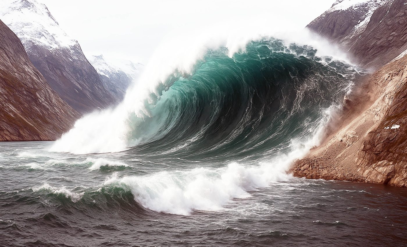
On September 16, 2023, more than 25 million cubic yards of rock and ice – enough to fill 10,000 Olympic-size pools – broke loose and plunged into Dickson Fjord.
The impact hurled up a mega-tsunami wave, reaching about 650 feet high.
The surge barreled down the two-mile corridor, bounced off the headland, and tore back again, wrecking roughly $200,000 in equipment at an empty research post on Ella Island.
Water did not calm after the first pass. Instead, it began rocking from wall to wall, a motion known as a seiche.
Computer models later showed the surface rising as much as 30 feet, then sinking the same amount in a steady rhythm that pressed on the seafloor like a giant piston.
Unusual heartbeat in the crust
Seismic stations normally record frantic scribbles during earthquakes. This time, the trace formed smooth peaks spaced a minute and a half apart and barely weakened over the better part of two weeks.
No seiche had ever produced such a persistent global signature. One modeling group pegged the slosh at about 8½ feet; a second group estimated 23 to 30 feet.
The disagreement stemmed from different assumptions about the fjord’s shape, but both sets of simulations agreed on the source: the landslide-driven wave.
“It was a big challenge to do an accurate computer simulation of such a long-lasting, sloshing tsunami,” said Alice Gabriel of UC San Diego’s Scripps Institution of Oceanography.
Investigators follow the clues
The mystery drew seventy-plus researchers from forty-one institutions.
“When we set out on this scientific adventure, everybody was puzzled and no one had the faintest idea what caused this signal,” said Kristian Svennevig of the Geological Survey of Denmark and Greenland.
“All we knew was that it was somehow associated with the landslide. We only managed to solve this enigma through a huge interdisciplinary and international effort.”

Field teams measured fresh gouges high on the cliffs, while supercomputers recreated the avalanche’s path and the fjord’s response.
“It was exciting to be working on such a puzzling problem with an interdisciplinary and international team of scientists,” said Robert Anthony of the U.S. Geological Survey.
“Ultimately, it took a plethora of geophysical observations and numerical modeling from researchers across many countries to put the puzzle together and get a complete picture of what had occurred.”
Climate’s silent hand
Glacier ice once buttressed the failing slope, but warming air and ocean water have eaten away at that natural brace.
“Climate change is shifting what is typical on Earth, and it can set unusual events into motion,” Gabriel noted.
Similar instability elsewhere triggered a deadly tsunami in Karrat Fjord in 2017 that destroyed eleven houses and claimed four lives.
Dickson Fjord sits near a popular cruise route. Though no passengers were present last year, the episode highlights rising risks as Arctic travel grows.
Authorities are now reviewing early-warning options that combine satellite feeds with real-time seismic data.
Satellites sharpen the picture
Conventional radar altimeters see only a thin line beneath each spacecraft. By contrast, the Surface Water and Ocean Topography (SWOT) mission launched in December 2022 maps a 30-mile-wide swath with 8-foot resolution.
“Climate change is driving the emergence of unprecedented extremes, particularly in remote regions like the Arctic, where our ability to monitor conditions using traditional physical sensors is limited,” explained Thomas Monahan of the University of Oxford.
“SWOT represents a breakthrough in our ability to study oceanic processes in areas such as fjords – places that have long posed challenges for earlier satellite technologies,” Monahan continued.

“This research highlights how next-generation Earth observation satellites can transform our understanding of these dynamic environments.”
Professor Thomas Adcock, also from Oxford, remarked, “This study demonstrates how advanced satellite data can finally illuminate phenomena that have eluded us for years.”
He added, “We’re now gaining new insights into oceanic extremes like tsunamis, storm surges, and rogue waves. To fully harness the potential of these new datasets, we’ll need to push the boundaries of both machine learning and our understanding of ocean physics.”
Lessons from Dickson Fjord
Researchers are now combing seismic archives for similar slow pulses.
“This shows there is stuff out there that we still don’t understand and haven’t seen before,” said Carl Ebeling of Scripps.
“The essence of science is trying to answer a question we don’t know the answer to – that’s why this was so exciting to work on.”
Every new discovery will refine models of how slope failure, fjord geometry, and water depth interact.
Better forecasts could one day provide critical minutes of warning for ships and settlements in high-latitude waters – proof that even the quietest corners of the planet deserve a closer listen.
The full study was published in the journal Science and Nature Communications.
—–
Like what you read? Subscribe to our newsletter for engaging articles, exclusive content, and the latest updates.
Check us out on EarthSnap, a free app brought to you by Eric Ralls and Earth.com.
—–


