900 years ago, ancient Americans somehow moved a 5-ton tree over 100 miles
Nine centuries ago, workers erected a colossal tree trunk in a central plaza in the city of Cahokia. The pole, known today as the Mitchell log, stood as a landmark to be seen from afar. It had been moved a great distance from where it had originally stood, especially for that time period.
Researchers have now confirmed that the tree was felled in 1124 and set up at a ceremonial center just east of today’s St. Louis, Missouri.

The Cahokia tree’s journey stretched more than 100 miles (180 kilometers), a feat that indicates planning, labor, and shared purpose.
Studying the Cahokia tree trunk
A new study dates the felling of Cahokia’s largest known ceremonial marker post, the Mitchell log, to 1124 and shows it came from far outside the city’s home floodplain. The post began as a bald cypress trunk and once stood about 59 feet (18 meters) tall.
The work was led by Nicholas V. Kessler, an assistant research professor at the University of Arizona (UA). His research focuses on dendrochronology, which is the science of dating tree rings.
At its height between 1050 and 1200, Cahokia held as many as 20,000 residents gathered into neighborhoods, plazas, and massive earthen mounds.
Monumental poles like the Mitchell log rose in those public spaces and in sacred precincts.
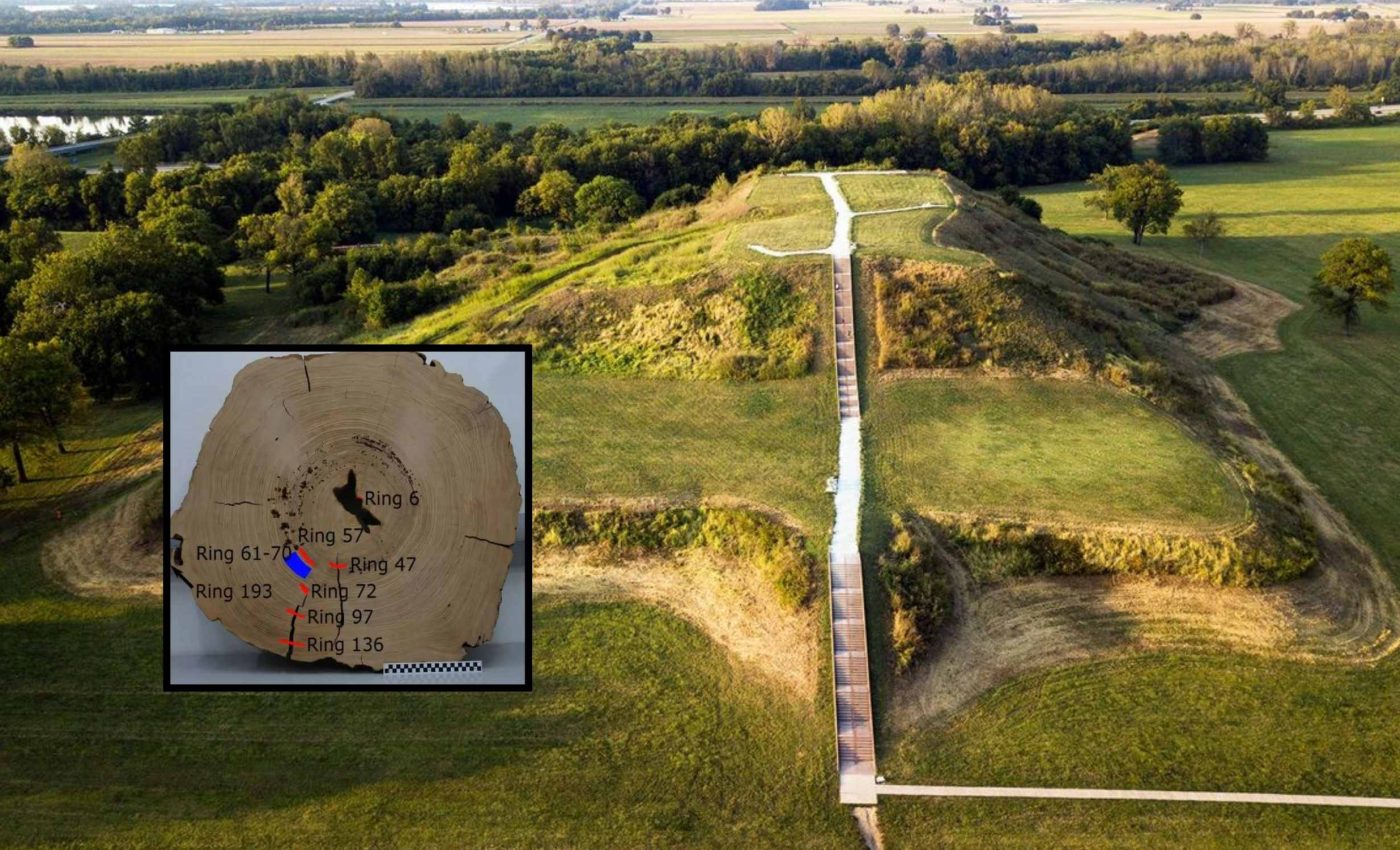
Kessler explained that the tree was felled around 1124 CE and that strontium isotope ratios in the wood ruled out a local source.
Cahokia tree rings tell time
Tree rings are a record of annual growth, and their chemistry records changes in the air. High precision radiocarbon, a form of carbon used to date once-living things, can match ring sequences to known year-by-year patterns.
Scientists also use the 993 to 994 event, a brief surge in atmospheric radiocarbon from intense solar storms, to lock a wooden object to an exact calendar year. The Mitchell log’s ring chemistry crossed that signal and narrowed the year of felling to 1124.
By reading the sapwood near the outer bark, the team could state that the tree died just before late summer growth. That detail adds confidence to the annual date.
Fixing the year puts the pole within Cahokia’s most expansive phase. The date aligns with the city’s largest workforce, densest neighborhoods, and widest influence across the Mississippi Valley.
It also falls just before major changes in climate and politics took hold. Multiple records show drier summers starting around 1150, with evidence from sediment indicating severe drought periods that reshaped farming and water use.
Tracing origin with strontium
The team paired tree rings with chemical sourcing. A strontium isotope ratio, a chemical fingerprint tied to local rocks and water, can reveal where a tree drew its nutrients.
Scientists compare those ratios to an isotope isoscape, a geographic map of isotope variation, to estimate source regions. A recent open access review describes how such maps guide provenance work for wood, animals, and people.
Measurements from the Mitchell Log did not match Cahokia’s local signature. The closest match pointed to areas at least 110 miles (180 kilometers) away in southern Illinois and the lower Ohio River valley.
Why cypress, and why so far
Bald cypress thrives in swamps and backwaters. Its straight trunks can yield long, uniform poles that resist rot.
Its modern native range reaches into the southern tip of Illinois, but not the higher parts of the American Bottom where Cahokia’s core neighborhoods spread.
That pattern supports the chemical case that the pole was imported, not harvested just outside the city gates.
How did people move a trunk that heavy across that distance? The simplest answer is water; they may have used rafts or boats on feeder streams that led into the Mississippi, and then upstream to the site.
Overland hauling on packed trails is also possible, using teams and rollers. Either method demands coordination, food, and tools, all signs of a city that organized big projects well.
Cahokia tree and public life
Cahokians placed large poles in plazas, atop mounds, and near civic buildings. Some served as sightlines and markers for ceremonies that ordered the calendar.
Written accounts do not survive, but archaeology suggests these poles were treated as living presences. Many communities across the region shared that practice, where a major pole acted as an axis mundi, a central link that joined sky, earth, and the world below.
Archaeological pits show where poles were set and later removed. By the early 1200s those features became scarce in the central precincts, even as the city still stood.
The Mitchell Log likely remained in place for several decades before decay forced its removal. That span overlaps the years when some ceremonial spaces were being reworked and outlying centers were being abandoned.
By 1200 the pace of new monument building slowed. Fewer non-local materials appeared in elite spaces, and public labor shifted from grand works to maintenance.
Household life changed as well. People left some neighborhoods while others were rebuilt with different layouts and priorities.
What we still do not know
Archaeologists often work with ranges of time rather than exact years. A firm date from 1124 pins a specific act to a known moment in the city’s growth.
That anchor lets researchers line up other sequences, from mound constructions to neighborhood relocations. It also frames when supply lines were strongest and when they began to fray.
Thousands of posts likely stood across Greater Cahokia during its peak. Most decayed, were burned as fuel, or were removed and lost to time.
Future work will test whether many poles were pulled around the same years, or whether neighborhoods followed their own timelines. More high resolution dating could also separate citywide choices from local ones.
Lessons from the Cahokia tree
Moving such a tree meant weeks of scouting, felling, trimming, and transport. It meant meals for crews, repaired boats, and strong leadership to keep a project on track.
The result was a monument that citizens could see from far off. It signaled identity, authority, and a shared place in the landscape.
Cahokia was not a loose cluster of hamlets. It was an organized city able to gather labor, manage far reaching supply chains, and maintain civic rituals for generations.
The Mitchell Log captures that capacity at a precise moment. It stands as a clear time stamp on the city’s rise and the onset of change that would reshape it.
The study is published in PLOS One.
—–
Like what you read? Subscribe to our newsletter for engaging articles, exclusive content, and the latest updates.
Check us out on EarthSnap, a free app brought to you by Eric Ralls and Earth.com.
—–


