Ancient river systems suggest that Mars was much wetter than previously believed
Mars holds far more fossil rivers than anyone realized. More than 9,320 miles of sinuous, ridge-like channels lace its southern highlands, hinting at a planet once rich in stable surface water.
The discovery comes from a team led by PhD candidate Adam Losekoot at the Open University.

Working with colleagues and funded by the UK Space Agency, Losekoot mapped dozens of fluvial sinuous ridges – also called inverted channels – in Noachis Terra. She then pieced together a new story for the Red Planet’s climate about 3.7 billion years ago.
Underexplored regions on Mars
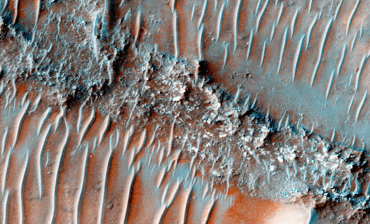
A fluvial sinuous ridge forms when a river lays down sediment that later hardens. As wind or water erodes the softer ground beside the deposit, the old riverbed flips from a low channel to a raised spine.
Seen from orbit, it snakes across the landscape like a dried vein. Because the ridge marks a former stream, its presence is direct evidence of flowing water rather than ice runoff or chemical trickery.
“Studying Mars, particularly an underexplored region like Noachis Terra, is really exciting because it’s an environment which has been largely unchanged for billions of years,” Losekoot said.
“It’s a time capsule that records fundamental geological processes in a way that just isn’t possible here on Earth.”
Noachis Terra lies in the planet’s ancient southern highlands, a rugged sector that has long seemed quiet compared with the famous valleys of Arabia Terra or the deltas at Jezero Crater.
Its scarcity of branching valley networks led some scientists to view it as a dry, mostly frozen plateau during early Martian history.
Mars mapped in high detail
The team combined images and elevation data from NASA’s Context Camera, the Mars Orbiter Laser Altimeter, and the High-Resolution Imaging Science Experiment.
Together these instruments trace features as small as a few feet high over areas hundreds of miles wide.
Software tools then flagged elongated ridges, measured their heights, and logged their paths. Some systems stretched across mere miles, while others stretched hundreds of miles – rising tens of feet above the surrounding plains.
Widespread rivers once flowed
The map revealed ridges scattered across many kinds of terrain. They do not huddle in crater floors alone but cut across inter-crater plains, crater walls, and high ground.
The extent of ancient rivers on Mars is indicative of a hydrological cycle powered by precipitation rather than isolated bursts from melting ice sheets.

Water must have fallen from the sky, collected in streams, and flowed long enough to build up thick beds of sand and gravel that later cemented into rock.
Mars shifted slowly to cold
All lines of evidence point to the Noachian-Hesperian boundary, roughly 3.7 billion years ago – a span when Mars shifted from its wettest known era toward a colder, thinner-air world.
The ridges suggest that, at least in Noachis Terra, warm and wet spells were not fleeting. River activity persisted long enough to carve extensive drainage and leave behind hardened deposits.
The findings undercut views that late-Noachian Mars was dry except for brief interludes triggered by volcanoes or asteroid impacts.
Hidden rivers revealed on Mars
Traditional climate reconstructions have leaned on valley networks – branching erosional troughs that act like dried-up tributary webs. Noachis Terra hosts few of those features, so past global surveys glossed over it.
By shifting the focus to inverted channels, the new study opens a fresh window on terrain that satellites have photographed but researchers seldom mined for climate clues.
The cumulative ridge length spans more than 9,000 miles – comparable to the present-day length of the Amazon River system.

While the original streams were narrower than the ridges that mark them, the sheer distance suggests abundant runoff.
To deposit and cement such volumes of sediment, water must have flowed season after season rather than in single catastrophic floods.
Thicker air, stable flow
Long-lived rivers need pressure and warmth to keep liquid from flashing into vapor under Martian gravity.
The evidence supports models in which early Mars carried a thicker carbon-rich atmosphere or received extra greenhouse boost from water-ice clouds.
Either way, conditions would have been friendlier for life, raising the odds that Noachis Terra once nursed habitable niches.
Mars may have stayed warm
Current rival models picture a frigid ancient Mars, warmed only in rare spurts when volcanoes released steam or impacts melted buried ice. Those scenarios struggle to explain ridge networks that record sustained flow.
The new map suggests the climate pendulum did not swing from deep freeze to brief thaw but instead lingered for geologically meaningful intervals in a temperate state.
“Our work is a new piece of evidence that suggests that Mars was once a much more complex and active planet than it is now, which is such an exciting thing to be involved in,” Losekoot said.

Future high-resolution topographic missions could hunt for smaller or heavily eroded ridges, refining the timeline of river activity.
Rovers or landers might someday target Noachis Terra to sample ridge-crested rocks, probing their minerals for signs of slow water deposition or even ancient biosignatures.
Implications beyond Mars
Understanding inverted channels also helps planetary geologists read other worlds. Similar features appear in satellite images of Earth’s deserts and may lurk on Venus beneath its clouds.
The work highlights how subtle landforms can rewrite climate history long after rivers dry up.
Noachis Terra, once overlooked, now emerges as a vast fossil watershed. Its ridges sketch a wetter Mars, where rain fell, rivers wandered, and sediments lit up under a thicker sky.
Each kilometer of braided stone revives a chapter of hydrologic complexity that scientists are only beginning to decode.
The research was presented at the Royal Astronomical Society’s National Astronomy Meeting 2025 in Durham.
Image Credit: ESA
—–
Like what you read? Subscribe to our newsletter for engaging articles, exclusive content, and the latest updates.
Check us out on EarthSnap, a free app brought to you by Eric Ralls and Earth.com.
—–


