
Powerful new eye in the sky: NISAR's stunning first images revealed
The most advanced Earth radar satellite ever launched, NISAR’s first test images are already showing how it could transform the way we monitor the planet, from tracking crop health to spotting earthquake risks.
And it hasn’t even kicked into full science mode yet.

Built through a rare U.S.-India partnership, this spacecraft is packed with new radar technology that can scan deep into forests, farmlands, and even under layers of ice.
Its main job is to watch how Earth changes over time – and give scientists and decision-makers the data they need to act.
NISAR begins its mission
In late August, NISAR’s radar systems turned on for a series of test runs. The satellite, launched by India’s space agency on July 30, 2025, is now orbiting Earth at an altitude of 464 miles (747 kilometers).
The first test images captured by NISAR are truly impressive.
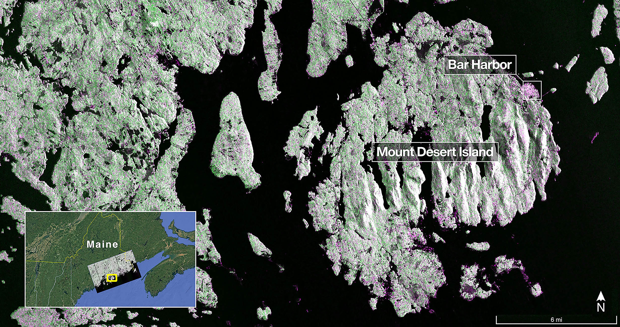
One image captured Mount Desert Island off the coast of Maine. Dark patches in the radar image show water, green areas indicate forests, and bright magenta highlights hard surfaces like buildings or bare ground.
Narrow waterways and tiny islands stand out clearly, even though they are only a few feet wide. That level of detail demonstrates how sharp NISAR’s sensors are.
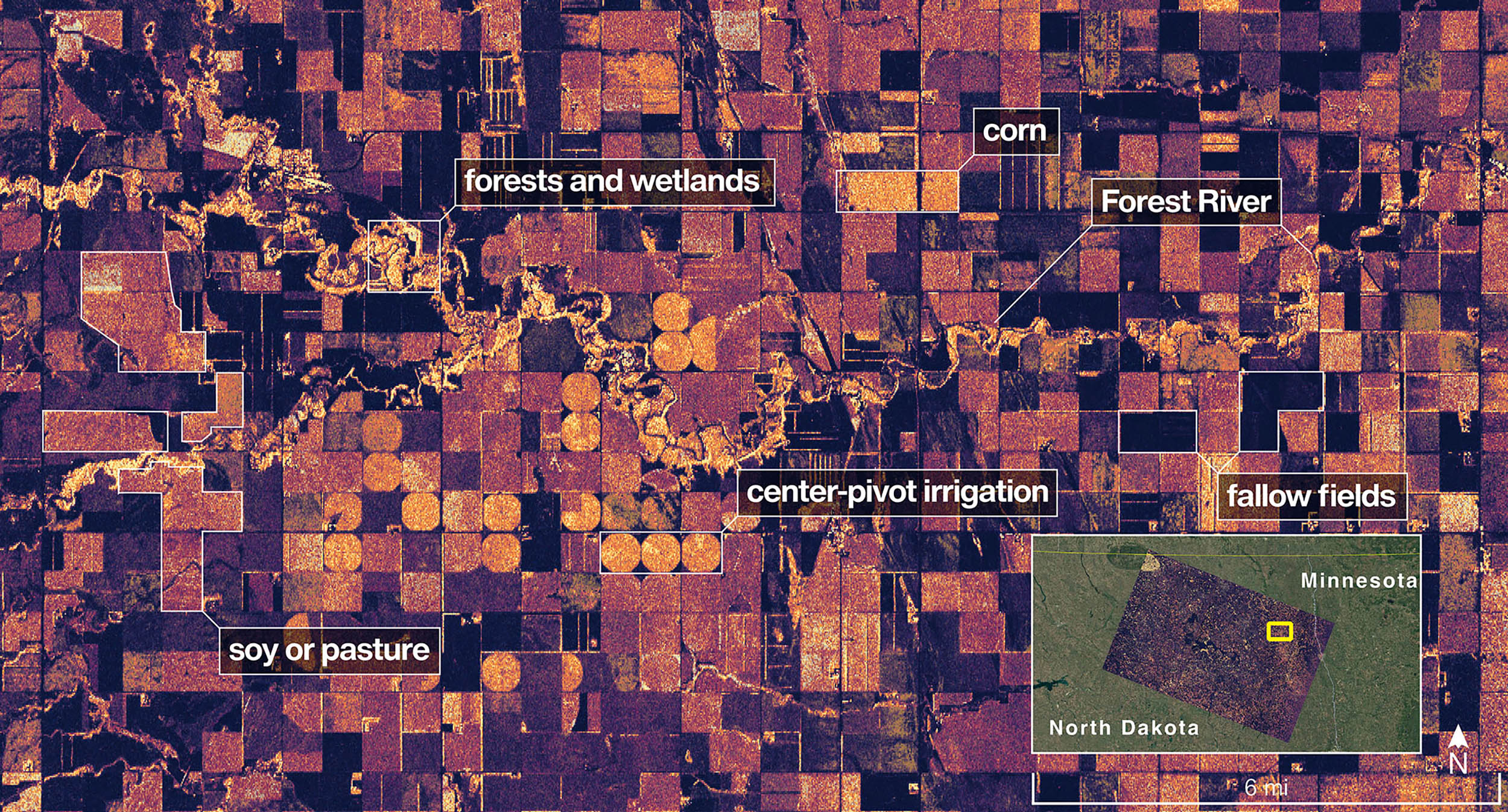
Another test image shows a piece of northeastern North Dakota, cutting through Grand Forks and Walsh counties. The radar picked up forests and wetlands lining the Forest River, plus farmland stretching north and south.
Circular irrigation patterns are visible, along with differences in crop type – some areas were fallow, while others were growing soybeans or corn.
What makes NISAR different?
Unlike satellites that rely on cameras, NISAR uses radar to scan Earth’s surface. It sends out microwave signals that bounce off the ground and return to the satellite.
The timing and strength of those signals help reveal conditions on the ground – such as soil moisture, forest density, or changes in ice levels at the poles.
NISAR carries two radar systems on board: L-band and S-band. The L-band radar, built by NASA’s Jet Propulsion Laboratory (JPL), uses a longer wavelength – about 10 inches (25 centimeters) – which lets it “see” through forest canopies and pick up even the smallest shifts in the ground.
That kind of detail helps scientists track things, like earthquakes, landslides, or volcanic activity, before and after they happen.
The S-band radar, developed by India’s Space Applications Centre, focuses on finer vegetation. It’s better suited for monitoring crops, grasses, and changes in farmland over time.
With both radar types working together, NISAR will scan the planet’s land and ice surfaces every six days, twice in that cycle. It does all this using a massive 39-foot (12-meter) wide antenna – the biggest of its kind that NASA has ever put into orbit.
Rare global partnership
The mission is the result of years of technical work between NASA and the Indian Space Research Organisation (ISRO). Their teams shared not only the science but also the engineering work.
ISRO built the spacecraft’s body and launch systems, while NASA handled the radar systems and data communications.
“This is only the beginning. NASA will continue to build upon the incredible scientific advancements of the past and present as we pursue our goal to maintain our nation’s space dominance through gold standard science,” said acting NASA administrator Sean Duffy.
With the full science phase set to begin in November, expectations are high.
“These initial images are just a preview of the hard-hitting science that NISAR will produce – data and insights that will enable scientists to study Earth’s changing land and ice surfaces in unprecedented detail,” said Nicky Fox, associate administrator of the Science Mission Directorate at NASA Headquarters.
Bigger goals beyond Earth
The benefits will extend beyond Earth science. Understanding how land shifts, how ecosystems change, and how water cycles function could help scientists make better predictions about other planets as well.
“By understanding how our home planet works, we can produce models and analysis of how other planets in our solar system and beyond work, as we prepare to send humanity on an epic journey back to the Moon and onward to Mars,” said NASA associate administrator Amit Kshatriya.
NISAR’s early images aren’t just snapshots – they’re signals of what’s coming. A spacecraft designed to quietly orbit Earth is about to become one of the loudest voices in global science. And it’s just getting started.I
Information from a NASA online press release.
Image credit: NASA/JPL-Caltech
—–
Like what you read? Subscribe to our newsletter for engaging articles, exclusive content, and the latest updates.
Check us out on EarthSnap, a free app brought to you by Eric Ralls and Earth.com.
—–


