Radar sees strange 'plasma bubbles' over the pyramids of Egypt from 5,000 miles away
A remote radar station on China’s Hainan Island has spotted an ionospheric disturbance hovering above the Pyramids of Giza, nearly 5,000 miles to the west.
The sighting shows how far equatorial plasma bubble tracking has come, and it hints at new ways to protect the satellites and signals that knit the modern world together.
Plasma bubbles and Chinese radar

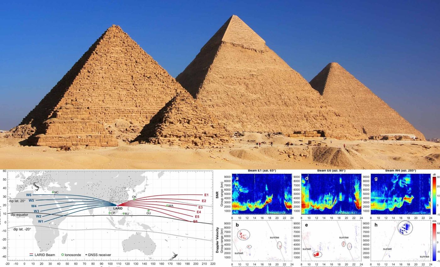
Lead author Lianhuan Hu of the Institute of Geology and Geophysics at the Chinese Academy of Sciences, heads the team that built the Low Latitude Long Range Ionospheric Radar, or LARID.
The phased‑array system designed by the researchers according to the study, fires high‑frequency pulses that bounce off the ionosphere, letting scientists map pockets of rarefied plasma far beyond the local horizon.
During a geomagnetic storm in November of 2024, LARID recorded a bubble over Egypt while its antennas faced west, confirming a maximum detection range of about 5,965 miles.
That span is more than three times the reach reported when the radar began test operations in early 2024, a gain achieved through software tweaks and better ionospheric modeling.
Why plasma bubbles matter
A plasma bubble is a cavern of depleted electrons that rises after sunset along Earth’s magnetic field lines, sometimes stretching hundreds of miles in diameter.
Inside its rippling walls, radio scintillation disrupts GPS navigation, satellite TV, stock‑market time stamps, and even airline routes.
“The walls of these equatorial plasma bubbles are where the communication and navigation signals are corrupted,” noted a NASA factsheet for the CINDI satellite mission.
Because the bubbles flare up unpredictably, forecasters need real-time views that cover vast tropical oceans where ground sensors are scarce.
How the radar reaches so far
LARID transmits at 20 MHz, a sweet spot where the ionosphere refracts the beam back toward Earth instead of letting it escape to space.
Each bounce, called a “hop,” extends the footprint; after one‑and‑a‑half hops, echoes can return from Africa or the central Pacific.
For comparison, the high‑latitude SuperDARN radars, workhorses of auroral science, cover about 2,240 miles apiece, with a 2,237‑mile slant‑range limit.
Hu’s radar system has 40 antennas, aimed both east and west, that can quickly shift their direction to scan a wide area of the sky in under a minute.
LARID radar echoes
The radar doesn’t observe plasma bubbles directly. Instead, it detects irregular echoes created by ionospheric scintillation, where signals scatter off unstable blobs of plasma at the edges of a bubble.
To isolate these echoes from clutter or reflections off terrain, researchers look at Doppler shifts, signal width, and signal-to-noise ratios.

Fast‑moving echoes with broad spectral width and strong return strength signal active ionospheric disturbances.
Plasma bubbles and space weather
The Egyptian bubble appeared soon after the interplanetary magnetic field flipped southward, sparking a Kp 7 geomagnetic storm.
That flip boosted eastward electric fields at dusk, lofting the equatorial F‑layer and priming conditions for the Rayleigh-Taylor instability that seeds bubbles.
Ground GPS receivers in Africa registered sharp jumps in total electron content rate, an independent confirmation that the patch over Giza was real, not a radar artifact.
In the same storm, LARID saw bubbles over the Pacific at sunset and again near Southeast Asia just before dawn, proving that one instrument can chase the nightly “space weather” tide across twelve time zones.
Toward a global watch
“The results provide meaningful insight for building a low latitude over‑the‑horizon radar network in future,” Hu and colleagues wrote, arguing that three or four such stations could survey the whole equatorial belt in real time.
Placing sister arrays in Brazil, Indonesia, and West Africa would close today’s oceanic gaps and let operators reroute critical links before outages strike.
Beyond civilian uses, militaries eye the data to shield over‑the‑horizon radars, HF communications, and encrypted satellite relays from sudden fades.
Agencies that manage GNSS augmentation systems could feed bubble alerts into integrity monitors, trimming false alarms and keeping precision farming tractors or aircraft autoland systems online.
What comes next
Hu’s group is already experimenting with multi‑frequency sweeps that pinpoint bubble altitude, a metric vital for assimilating observations into physics‑based forecast models.
They are also sharing echo maps with the international SuperDARN community to cross‑check mid‑latitude disturbances that spill out of the tropics.
If funding aligns, a portable mini‑LARID may debut on Reunion Island in the Indian Ocean, extending coverage into a longitude sector notorious for sat‑nav dropouts during solar maximum.
A successful trial there would cement the case for the global quartet and help stitch ionospheric weather into mainstream meteorology.
The study is published in Geophysical Research Letters.
—–
Like what you read? Subscribe to our newsletter for engaging articles, exclusive content, and the latest updates.
Check us out on EarthSnap, a free app brought to you by Eric Ralls and Earth.com.
—–


