Scientists found a huge crack beneath one of the most dangerous volcanoes on the planet
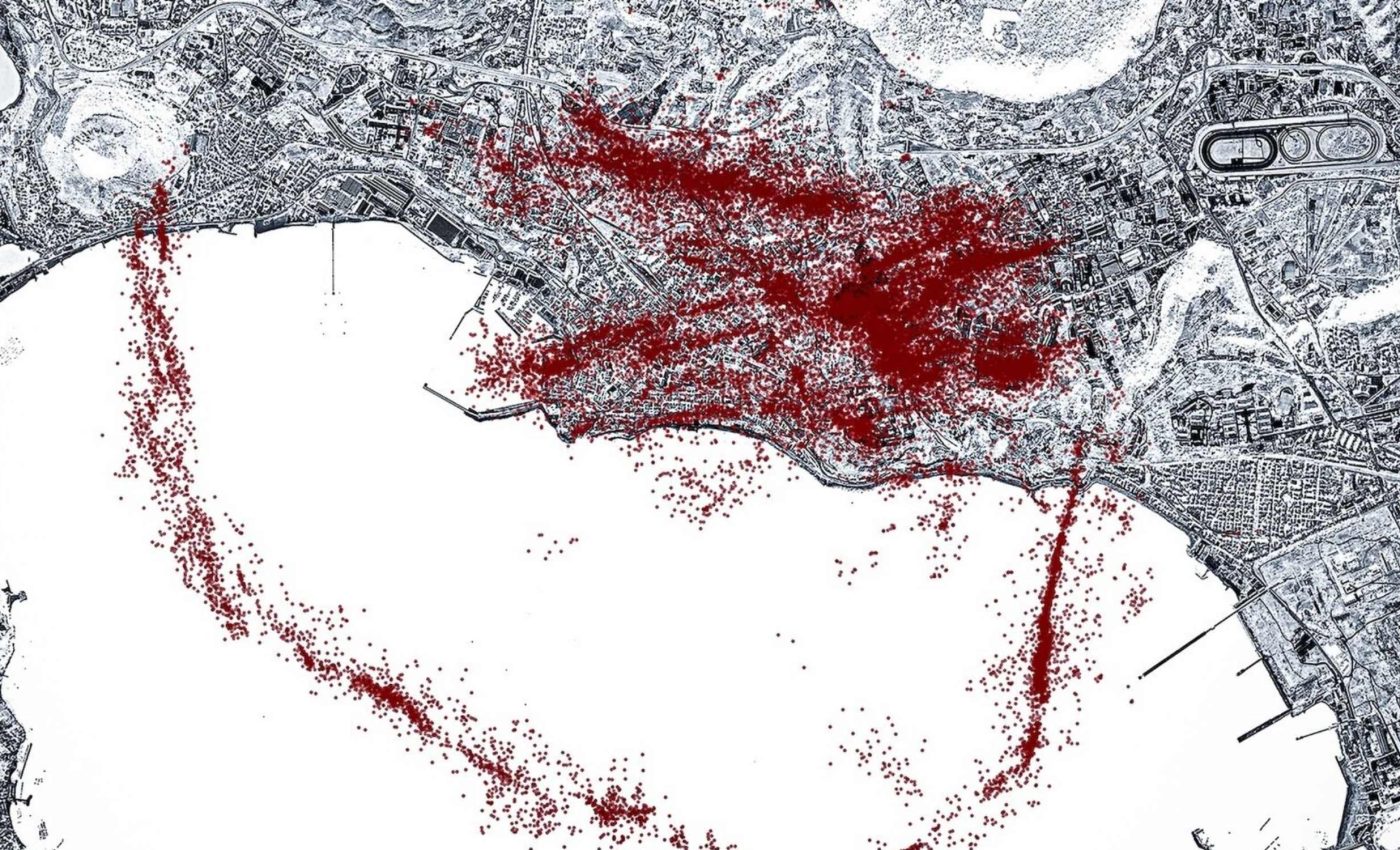
An artificial intelligence study mapped more than 54,000 earthquakes at Italy’s Campi Flegrei since 2022, revealing a crisp ring shaped fault that had been hiding in plain sight.
The caldera sits just west of Naples and spans about 7 miles, with neighborhoods built across its floor and rim.

The work was led by Xing Tan, a doctoral researcher at Stanford University. His research focuses on machine learning for seismic monitoring.
Ring fault at Campi Flegrei
A ring fault, a circular fracture that outlines a collapsed volcanic basin, can channel stress and guide earthquake locations. USGS describes how ring fractures shape calderas and influence later unrest.
At Campi Flegrei, the new map outlines a thin, well marked ring that tracks the zone of uplift and even extends offshore. The pattern brings the system’s architecture into focus and links recent shaking to that structure.
“Our Italian colleagues were surprised to see the ring so clearly,” added lead study author.
The discovery reshapes how scientists interpret the volcano’s inner structure, giving them a precise outline of stress zones that were previously invisible.
Studying Campi Flegrei with AI
Seismologists traditionally rely on phase picking, the step where analysts mark the first wiggles from distant earthquakes on seismograms. Machines can now learn this task from millions of labeled examples and apply it to continuous data.
That training paid off by recognizing tiny, overlapping signals that older methods missed. With more events and sharper locations, the catalog shows where faults align and where stress is building.
The researchers noted that the new system is now capable of delivering much clearer views of underground activity.
They explained that the technology has moved beyond testing and is being used in real time to detect subtle shifts and locate small earthquakes with far greater accuracy than before.
What the swarm says about risk
The deepened catalog shows two long faults converging under Pozzuoli, a town on the caldera’s north side. Those structures raise concern for stronger shaking in a shallow, urban setting.
An earthquake in the magnitude 5 range is not out of the question. Researchers emphasized that the area has long been known to pose significant risks, recalling that part of the city was evacuated in the 1980s.
They explained that, for the first time, the underlying geologic structures responsible for that danger are now clearly visible.
The same analysis highlights a strictly shallow band of activity, all above about 2.5 miles, with no sign of upward moving magma. That picture points to pressurized fluids and faults as the drivers for now.
Monitoring Campi Flegrei
Campi Flegrei rises and sinks in pulses called bradyseism, slow ground up and down driven by pressure changes in the subsurface. Since April 2025, the average uplift has held near 15 millimeters per month.
Uplift of about 0.6 inches each month adds stress to faults and to buildings. The ring fault alignment suggests that any future bursts of shaking may circle the uplifted zone.
Italy’s Civil Protection maintains an emergency plan that divides the area into red and yellow zones for eruption and ash hazards. That guidance sets routes and priorities so local officials can respond quickly if conditions change.
For residents, the practical takeaways are simple. Know your zone, secure heavy furniture, and follow INGV updates during swarms.
What the new map changes
A caldera, a large volcanic depression formed after major eruptions, often holds many small faults. The new map sorts scattered dots into clear lines, which lets engineers estimate the realistic range of shaking a given fault can produce.
Those estimates have direct uses in building checks and emergency drills. A better grasp of where shaking is likely helps planners place shelters, ambulances, and road clearances.
The results also narrow scientific questions. If the ring fault lights up while uplift accelerates, the link between pressure in the shallow system and earthquakes strengthens.
Over time, that relationship could be tested as the tool watches the system in near real time. The same approach could be applied to other restless volcanic systems that already have seismic networks.
Lessons from Campi Flegrei ring fault
The model’s success at Campi Flegrei hinges on data coverage and careful retraining. As more stations come online and as analysts add examples, the model should keep improving.
Authorities now have a clearer map of where the ground is breaking. That clarity supports faster decisions when swarms begin or when a larger shock hits.
None of this predicts an eruption’s timing. It does show the pathways where stress is concentrating, which is exactly what communities need when the ground will not sit still.
The study is published in Science.
—–
Like what you read? Subscribe to our newsletter for engaging articles, exclusive content, and the latest updates.
Check us out on EarthSnap, a free app brought to you by Eric Ralls and Earth.com.
—–


