SWOT satellite captures tsunami triggered by Kamchatka earthquake
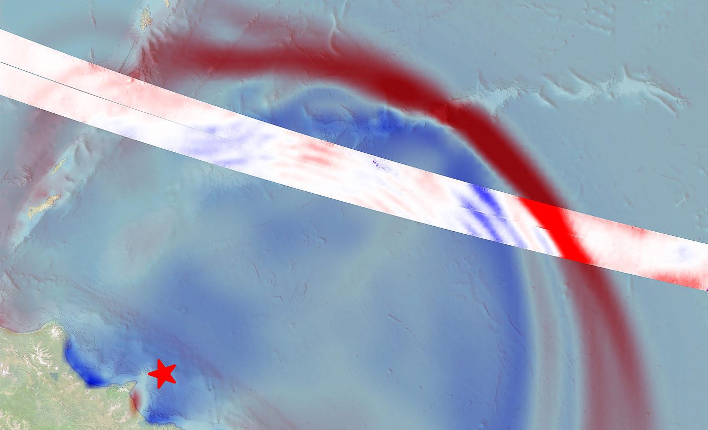
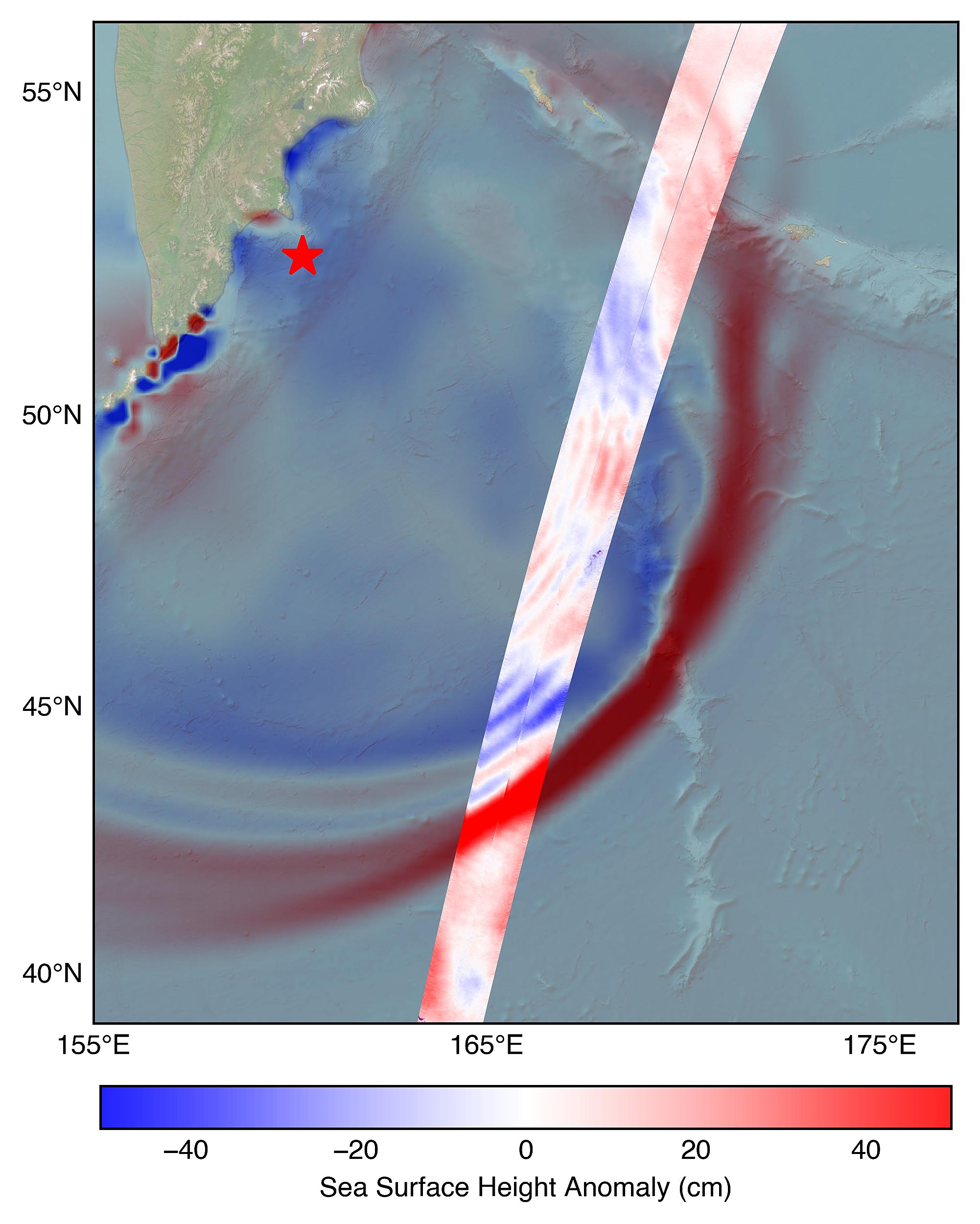
On July 30, at 11:25 a.m. local time, a massive magnitude 8.8 earthquake set off a tsunami near Russia’s Kamchatka Peninsula. Seventy minutes later, a satellite captured the wave as it moved across the ocean.
The spacecraft, called SWOT (Surface Water and Ocean Topography), is operated jointly by NASA and the French space agency CNES (Centre National d’Études Spatiales). Its job is to measure water heights across the globe with exceptional detail.

On this day, it recorded a clear snapshot of the tsunami’s leading edge, providing scientists with crucial information for improving forecast models that protect coastal communities.
The making of a tsunami
Tsunamis form when a massive event, such as an earthquake or underwater landslide, shifts the entire column of seawater from the ocean floor to the surface.
This sudden movement forces huge amounts of water upward, creating waves that can travel at jet-like speeds across entire oceans. The disturbance sends out waves in all directions, much like ripples from a stone hitting a pond.
On a much larger scale, these waves can be powerful enough to reshape coastlines when they reach land.
In this case, SWOT’s sensors detected a tsunami in the open ocean near the Kamchatka Peninsula. It might have seemed small, but as one scientist explains, appearances can be deceiving.
“A 1.5-foot-tall wave might not seem like much, but tsunamis are waves that extend from the seafloor to the ocean’s surface,” said Ben Hamlington, an oceanographer at NASA’s Jet Propulsion Laboratory in Southern California.
“What might only be a foot or two in the open ocean can become a 30-foot wave in shallower water at the coast.”
Tracking tsunamis from space
The data SWOT gathered – including the height, shape, and travel direction of the tsunami – was compared with a forecast model produced by the U.S. National Oceanic and Atmospheric Administration (NOAA) Center for Tsunami Research.
This comparison is critical. It allows scientists to confirm that their models match what actually happens in the ocean.
“The power of SWOT’s broad, paintbrush-like strokes over the ocean is marking a leap towards more accurate early warnings and safer futures,” said Nadya Vinogradova Shiffer, NASA Earth lead and SWOT program scientist at NASA Headquarters in Washington.
For this event, the model lined up with reality. “The satellite observations help researchers to better reverse engineer the cause of a tsunami,” said Josh Willis, a JPL oceanographer. “In this case, they also showed us that NOAA’s tsunami forecast was right on the money.”
Stronger defense against tsunamis
For the scientists at NOAA’s Center for Tsunami Research, the results were encouraging. “It suggests SWOT data could significantly enhance operational tsunami forecasts – a capability sought since the 2004 Sumatra event,” said Vasily Titov, the center’s chief scientist in Seattle.
The 2004 Sumatra earthquake and tsunami killed hundreds of thousands of people and caused catastrophic damage across Indonesia and beyond.
The magnitude 9.1 quake struck off the coast of northern Sumatra, triggering waves that reached as high as 100 feet in some areas. Entire towns were wiped out, and the disaster affected more than a dozen countries around the Indian Ocean.
Since then, researchers have been working to improve warning systems so communities can respond before disaster strikes.
By blending SWOT’s satellite measurements with their existing forecast tools, NOAA aims to sharpen predictions and issue more accurate alerts. Even a few extra minutes of warning can make the difference between life and death for people living near the coast.
Better forecasts save lives
A wave that is only a foot or two high in the open ocean may not be of much concern. But if it has the right conditions, it can develop into something catastrophic by the time it gets to land. That’s why improved measurements – and quicker, more accurate forecasts – are such big deals.
The Kamchatka earthquake and tsunami was greater than a scientific discovery. It was evidence that space technology can serve directly to make life safer here on Earth.
And with satellites like SWOT now up and running, scientists are getting a clearer vision of how the ocean moves – and how we can remain one step ahead of nature’s most intense waves.
—–
Like what you read? Subscribe to our newsletter for engaging articles, exclusive content, and the latest updates.
Check us out on EarthSnap, a free app brought to you by Eric Ralls and Earth.com.
—–


