The Kafue Flats in Zambia
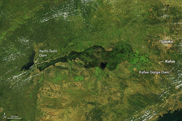
Today’s Image of the Day from NASA Earth Observatory features the Kafue Flats, a seasonally inundated floodplain surrounding the Kafue River in Zambia.
The Kafue River is the longest river flowing entirely within Zambia, running across more than 900 miles before joining the Zambezi River.
According to NASA, the disturbance caused by annual floods plays an important role in the Kafue Flats ecosystem. Historically, floods that peaked from March to May provided critical habitat for spawning fish, while the dry the floodplain provided food for grazers around October.
In the 1970s, dams were built upstream for hydropower, which altered the natural flooding patterns along the Kafue River.
Fritz Kleinschroth is a landscape ecologist at the Swiss Federal Institute of Technology (ETH Zürich), who has used satellite images and field surveys to study decades-long changes in the region.
“Since the dams were built, the natural dynamics of high and low flows have been strongly reduced,” said Kleinschroth.
“Nowadays, the less-flooded areas are dominated by shrublands, and the more permanently humid zones are comprised of reeds and species like papyrus.”
To reduce the impacts, people began to mimic the natural flooding dynamics with artificial flood releases, or “environmental flows.”
The Kafue Flats were recently flooded in this image, which was captured on April 1, 2021 by the Moderate Resolution Imaging Spectroradiometer (MODIS) on NASA’s Terra satellite.
Image Credit: NASA Earth Observatory
—
By Chrissy Sexton, Earth.com Staff Writer


News coming your way
