Archaeologist sailed on a Viking boat for three years, rewriting the history of these fierce explorers
There’s something timeless about a Viking boat cutting through the waves – raw wood, square sail, no compass, just human instinct and ancient knowledge. It’s a window into how these fierce and clever seafarers actually lived and moved.
For three years, one archaeologist has been retracing the maritime paths once taken by Viking sailors, not just to prove where they went, but to understand how they got there.

His journey has spanned thousands of kilometers, navigating frigid waters and pushing the limits of ancient boat design. What he discovered could change our view of Viking exploration forever.
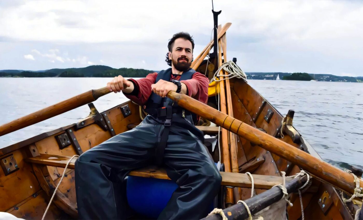
Greer Jarrett and his Viking boat
The work was led by researchers from Lund University in Sweden.
Using an open, square-rigged clinker boat modeled after those from the Viking Age (800–1050 AD), archaeologist Greer Jarrett and his team sailed over 5,000 kilometers (3,100 miles), from Trondheim to the Arctic Circle and back.
Their goal? To see just how far these boats could go – and how they managed open water voyages with no modern navigation tools.
“I can show that this type of boat sails well on open water, in tough conditions. But navigating close to land and in the fjords sometimes presents challenges that are just as great, but not as obvious,” said Jarrett, a doctoral student in archaeology at Lund.
He explained that factors such as underwater currents and katabatic winds blowing down from mountain slopes would have had significant impacts on navigational success.
Viking boat routes
Jarrett’s research shows that Viking ships likely traveled farther from shore than previously thought. These weren’t just coastal voyages hugging the land.
Instead, the Vikings may have used offshore routes across the Kattegat and Baltic Sea, which proves their vessels could handle tougher conditions than many assumed.
Despite lacking a deep-draught keel, the boats handled well. They remained stable and agile, even in the open sea. This directly challenges the idea that Vikings avoided long stretches away from land due to fears of instability.
Journey wrought with dangers
But these trips came with real danger. On one leg of the journey in 2022, the main support for the sail – the yard – snapped. The boat was 25 kilometers (15.5 miles) out in the Vestfjorden when it happened.
“We had to lash two oars together to hold the sail, and hope that it would hold. We made it back to the harbor safely, but then we had to spend several days repairing the boat before we could sail again,” recounted Jarrett.
Another time, a minke whale surfaced just meters from their boat, and slapped its massive tail fin into the water. Yet for all the physical risks, one of the biggest lessons was about people.
“The cold in the Lofoten Islands was a challenge. Our hands really suffered. At that point I realized just how crucial it is to have a good crew,” said Jarrett.
“You need a boat that can withstand all kinds of weather conditions. But if you don’t have a crew that can cooperate and put up with each other for long periods, these journeys would probably be impossible.”
Navigating Viking boats with stories
The Vikings didn’t rely on compasses or maps. Instead, they used memories, stories, and oral traditions to find their way. Coastal myths became mental landmarks that helped sailors remember dangerous spots or identify safe harbors.
Examples include Viking stories about the islands Torghatten, Hestmona and Skrova off the Norwegian coast. The stories serve to remind sailors of the dangers surrounding these places, or of their importance as navigation marks.

Jarrett refers to this system as a “Maritime Cultural Mindscape.” The idea is simple but powerful – stories turned the landscape into a living map that was passed down through generations.
To better understand Viking navigation, Jarrett also interviewed modern-day Norwegian sailors and fishermen. Many of their traditional 19th- and early 20th-century sea routes mirror those that might have been used a thousand years earlier.
“I used the experience of my own journeys and the sailors’ traditional knowledge to reconstruct possible Viking Age sailing routes.” he said.
How and where they slept
The new research also uncovers four likely Viking “havens” – small harbors located on islands and peninsulas, farther out to sea than previously known major ports. These spots may have played a key role in Viking travel and trade.
“With this type of boat, it has to be easy to get in and out of the harbor in all possible wind conditions. There must be several routes in and out. Shallow bays are not an issue because of the shallow draft of the boats,” explained Jarrett.
However, the boats were difficult to sail upwind with their square rigs, so sailing up the narrow fjords could prove tricky.
Trade route efficiency
Jarrett believes these decentralized ports made Viking trade more efficient. They provided shelter, opportunities to meet fellow sailors, and safe places to stop mid-journey – all of which would have been critical for long-distance voyages.
“A lot of the time, we only know about the starting and ending points of the trade that took place during the Viking Age. Major ports, such as Bergen and Trondheim in Norway, Ribe in Denmark, and Dublin in Ireland,” explained Jarrett.

“The thing I am interested in is what happened on the journeys between these major trading centers. My hypothesis is that this decentralized network of ports, located on small islands and peninsulas, was central to making trade efficient during the Viking Age,” Jarrett concluded.
Learning about Vikings by sailing their boats
Greer Jarrett’s hands-on voyage in a Viking boat reveals far more than just the technical capabilities of ancient ships. On his journeys, Jarrett also experienced the deep seam of cultural memory that guided Viking sailors across unforgiving waters.
Their navigation was rooted in oral traditions and shared experience, not instruments. And their strength lay not just in craftsmanship, but in cooperation, resilience, and an intimate relationship with the sea.
Jarrett’s fascinating research rewrites Viking maps and also rehumanizes the Vikings themselves, showing how memory, myth, and muscle worked together to shape an age of exploration.
Click here to watch a video about this expedition…
The full study was published in the journal Journal of Archaeological Method and Theory.
—–
Like what you read? Subscribe to our newsletter for engaging articles, exclusive content, and the latest updates.
Check us out on EarthSnap, a free app brought to you by Eric Ralls and Earth.com.
—–


