Arctic amplification is destabilizing the delicate balance of the ecosystem
The Arctic, a hotspot for climate change, is once more grabbing headlines. This remote region is warming faster than any other part of the world, creating a domino effect called Arctic amplification.
ESA-developed satellites are stepping up, offering vital data that shed light on this complex phenomenon and its far-reaching implications for people and wildlife alike.

The phenomenon of Arctic amplification involves the Arctic warming at a rate that surpasses the global average. It’s driven largely by feedback loops that intensify the warming effect of greenhouse gases.
This isn’t just disrupting the fragile equilibrium of the Arctic ecosystem, but it’s also having a significant impact on global climate patterns, human populations, and wildlife.
The ESA’s Science for Society Arktalas Hoavva project, whose name means Arctic Ocean in the northern Sami language, is focused on studying Arctic amplification using satellite data.
Remote sensing satellites are documenting the effects
A recent paper published in the journal Remote Sensing details how these satellites are providing invaluable insights into this remote region. These satellites have captured the effects of amplification on everything from phytoplankton productivity to human infrastructure.
Take for example the incident in May 2020. A power plant reservoir near Norilsk in Russia leaked some 20,000 tons of diesel, declaring a state of emergency. This oil spill contaminated the Ambarnaya River and Lake Pyasino.
A pillar collapse, caused by thawing permafrost destabilizing the ground, resulted in a disaster with costs exceeding $2 billion. Scientists, using data from the Copernicus Sentinel-2 satellite mission along with field photographs and historical data, attributed this accident to the Arctic amplification of global warming.
But the repercussions don’t stop at infrastructure. Thawing permafrost also releases vast quantities of methane and carbon dioxide, creating a dangerous feedback loop that intensifies global warming.
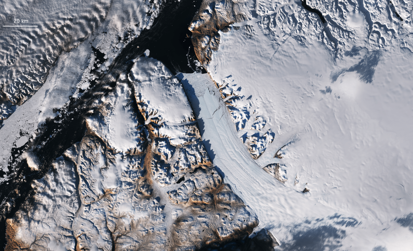
Disappearance of sea ice is biggest concern
Central to Arctic amplification is the disappearance of sea ice, which has plummeted to alarmingly low levels. Sea ice forms when seawater freezes into freshwater ice. The freezing process expels cold saline water, which then sinks into the deep ocean, driving global ocean thermohaline circulation. If sea ice formation stops, this process halts, leading to changes in global ocean circulation.
With less ice, the exposed ocean surface absorbs more heat, accelerating warming and ice loss. Moreover, winds over the open ocean increase surface waves, which in turn inhibit refreezing by mechanically eroding the forming ice, possibly driving new and more energetic ocean circulation patterns across the Arctic Ocean.
ESA’s CryoSat and Copernicus Sentinel-3 satellite altimeters measure Arctic sea-ice thickness. They precisely measure the height difference between ice and ocean surfaces, enabling scientists to calculate ice thickness and volume.
This data has uncovered significant drops in Arctic sea ice, particularly during summer, stressing the urgency of the situation. Additional measurements by the ESA SMOS satellite and infrared imagery from Sentinel-3 provide crucial all-weather sea-ice mapping capabilities.
More than just ice tracking
In addition to ice tracking, ESA-developed satellites observe other crucial parameters, like surface temperature, albedo, and atmospheric composition. These observations enable scientists to study the complex feedback mechanisms contributing to Arctic amplification.
For instance, the Copernicus Sentinel-3 mission supplies essential data on sea-surface temperatures, supporting analyses of oceanic heat fluxes and their impact on ice melt.
Meanwhile, the vast Greenland ice sheet, accelerated by Arctic amplification, is adding to global sea level rise. The freshwater released from melting ice into the North Atlantic Ocean is altering oceanic circulation patterns, potentially leading to extreme weather events, such as storms and heatwaves, around the world.
Long-term datasets are being assembled through ESA’s Climate Change Initiative. These 40-year-long datasets, created with data from numerous satellites, allow researchers to study long-term trends and variations in the Arctic, enhancing our understanding of the region’s reaction to global warming.
ESA satellites are improving our understanding of Arctic amplification
The wealth of data provided by these ESA-developed satellites improves our comprehension of Arctic amplification and aids in decision-making processes. This information is crucial in developing effective strategies to mitigate and adapt to these changes.
Governments, policymakers, and the scientific community rely heavily on these observations to assess environmental impacts, predict future scenarios, and create policies for sustainable Arctic management.
The Arctic’s importance is reflected in the evolving Copernicus system, which is prioritizing new Arctic measurements through innovative satellite capabilities. These include the dual-frequency CRISTAL altimeter, the Copernicus Imaging multi-frequency Microwave Radiometer (CIMR), and ROSE-L, an L-band synthetic aperture radar mission.
Together with existing Copernicus data, these satellite measurements will provide an unparalleled monitoring capability during a time of drastic climate shifts induced by human actions.
Researchers issue a stark warning
ESA’s Craig Donlon explains the criticality of this issue, stating, “The phenomenon of Arctic amplification and its relationship to the global climate emergency serves as a stark reminder that the consequences of climate change are not distant threats but immediate and accelerating crises, impacting not only people living in the Arctic, but ultimately all of us.”
“Our paper outlines how satellite observations have captured Arctic amplification as it is developing and with good spatial detail. These observations are indispensable for monitoring of amplification in this remote and inhospitable region that is sparsely sampled by ground observations.”
“Satellite data are unique in their ability to capture and monitor environmental transitions in the Arctic region that both precede and follow the emerging impact of Arctic amplification.”
As we face these daunting challenges, our understanding and management of Arctic amplification will hinge on these satellite observations. In this ever-warming world, it’s vital to harness this technology to navigate the choppy waters of climate change.
More about the Arctic and climate change
The Arctic, the northernmost region of the Earth, plays a crucial role in the planet’s overall climate and ecosystem health. It acts as a “refrigerator” for the world by helping to regulate global temperatures. However, it’s currently facing the brunt of climate change, with serious consequences for the entire planet.
The Arctic is home to a variety of ecosystems, from tundra vegetation and abundant marine life to its iconic ice-covered landscapes. Notably, the Arctic has massive layers of soil and rock called permafrost, which remains frozen throughout the year and stores large amounts of carbon dioxide and methane. These greenhouse gases, if released, can significantly amplify global warming.
But perhaps the Arctic’s most famous feature is its sea ice, which has an essential role in regulating the planet’s climate. Sea ice has a high albedo, meaning it reflects much of the sun’s rays back into space, helping to maintain the Earth’s energy balance. When sea ice melts, it reveals the darker ocean surface that absorbs more sunlight, leading to a warming cycle known as the ice-albedo feedback loop.
Impact of climate change on the Arctic
Climate change is impacting the Arctic at an alarming rate. In fact, the region is warming twice as fast as the rest of the planet in a process known as Arctic amplification. This rapid warming is leading to substantial reductions in sea ice, thawing of permafrost, shifts in wildlife populations, and changes in ocean circulation patterns.
Sea ice is now forming later in the fall and melting earlier in the spring, resulting in less ice cover overall. This loss of sea ice affects local wildlife such as polar bears and seals, who rely on it for hunting and breeding. The open waters also absorb more heat, causing further warming and ice melt in a self-reinforcing cycle.
The thawing of permafrost is another serious concern. When permafrost thaws, it releases the stored carbon dioxide and methane into the atmosphere, further exacerbating global warming. This process also destabilizes the ground, posing significant risks to infrastructure, as seen in the 2020 Norilsk oil spill.
Changes in the Arctic also have global implications. Melting ice contributes to sea level rise, threatening coastal communities around the world. Changes in sea ice and ocean conditions can alter weather patterns, potentially leading to more extreme weather events.
Despite these challenges, the Arctic remains a crucial part of Earth’s climate system. Its preservation is essential for the health of our planet. Mitigating climate change and preserving the Arctic will require international cooperation, sound environmental policy, and a commitment to sustainable practices on a global scale.
Satellite technology, such as that employed by the ESA, will continue to play an important role in understanding and monitoring these changes, informing the strategies we use to respond.
Image Credit: ESA
—-
Check us out on EarthSnap, a free app brought to you by Eric Ralls and Earth.com.


