Astronaut finds sacred lake, containing relics and mummies, has turned from blue to toxic green
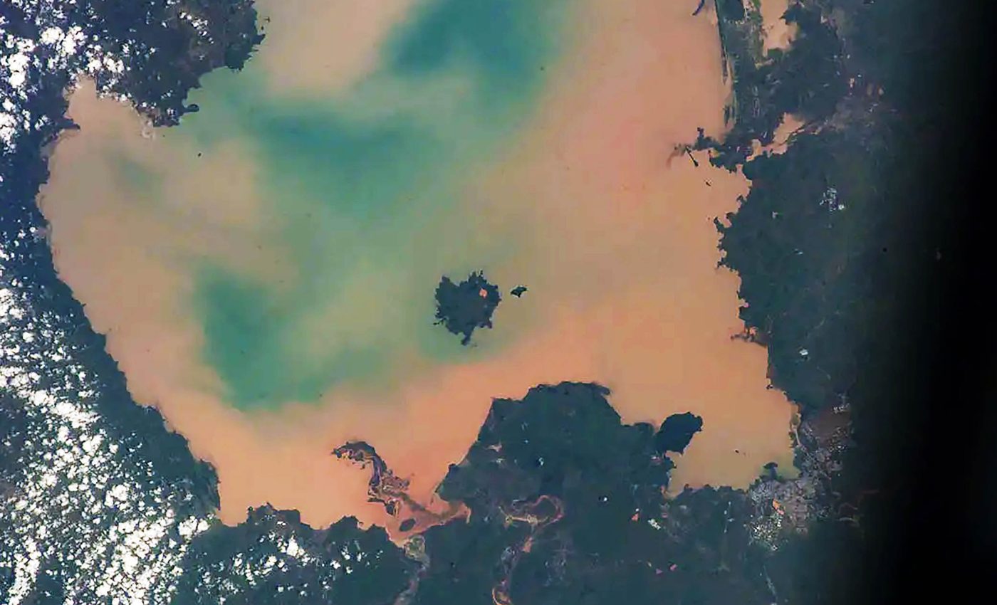
High above Earth, an astronaut looked down on northern Ethiopia. Below, Lake Tana, about 1,200 square miles across, held two dark islands whose monasteries guard the mummified remains of ancient emperors.
In the image, the lake glows an unhealthy milky green instead of deep blue. That color points to algae in the water and shows how farming and cities are reshaping one of Africa’s most important freshwater lakes.
Capturing Lake Tana from space

Recent satellite monitoring of Lake Tana was led by Bekalu Asres, a water resources engineer at Debre Markos University (DMU) in Ethiopia. His research tracks how satellite images reveal changes in water quality over time in Lake Tana and other vulnerable lakes.
From the International Space Station, 250 miles up, an astronaut captured a photograph of Dek and Daga Islands on January 2, 2017. Even from that height, the camera picked out bright tin roofs and long fields carved into the largest island.
Dek is the larger island, stretching about four and a half miles from end to end. Daga is smaller, a quiet wedge of land that holds a monastery rather than a permanent village.
Astronauts see the islands framed by pale water that looks almost like diluted paint. According to NASA, the murky green color of the water results from algal blooms, which ties the color to nutrient pollution from land.
A lake shaped by fire and water
Hydrology researchers estimate that Lake Tana averages about 30 feet deep and receives water from more than forty rivers and streams. Their work shows that this single lake holds a large share of Ethiopia’s surface fresh water.
Long ago, lava flows blocked older river valleys and created a natural basin in these highlands. Water slowly filled that basin and spilled out again, so Lake Tana became the high starting point for the Blue Nile.
Headwaters, the upstream beginning of a major river system, is the term scientists use for this role. Downstream, millions of people rely on the Blue Nile that begins here for drinking water, irrigation, and power.
Today Lake Tana is a UNESCO biosphere reserve, a protected landscape where people balance nature with human needs. The status highlights wetlands, islands, and villages that shelter native fish, migratory birds, and rare plants.
Life on Dek, the working island
Dek’s dark soils come from old volcanic rock that weathered into fertile sediment. Frequent thunderstorms drop rain here because the island sits under the Intertropical Convergence Zone, a belt near the equator where storms often build.
Agricultural fields make up over 70 percent of Dek Island, according to one NASA description. Coffee, mangos, corn, and millet fill much of that land, feeding the island’s roughly five thousand residents and supporting markets on the nearby shore.
Narrow dirt paths link farm plots to villages with metal roofs that glint in satellite images. Boats carry people, crops, and fuel between Dek and the lakeshore city of Bahir Dar, turning the island into a busy hub.
Even on Dek, farming stops for monasteries and churches set among trees. These compounds hold manuscripts, crosses, and painted walls that tie everyday life back to centuries of Ethiopian Orthodox tradition.
Daga, emperors, and forbidden shores
Daga Island lies closer to the lake‘s center and feels far more secluded. Its steep slopes rise above the water to the monastery of Daga Estifanos, which many pilgrims see as one of Ethiopia’s holiest places.
Inside the monastery, modern glass-sided coffins display the preserved bodies of several Ethiopian emperors to authorized visitors. Among them is Fasilides, the seventeenth century king who built famous stone palaces in the city of Gondar.
Local custom limits who can make that climb to the monastery. Women, and even female farm animals, are not allowed to set foot on Daga or enter its church courtyards.
More than thirty islands dot Lake Tana, and many host churches or monasteries hidden among trees. Island communities say that precious manuscripts, crowns, and crosses once moved to these sanctuaries during wars, safer behind water than on open plains.
Algae, runoff, and a warning from space
A recent satellite based study of chlorophyll, the pigment that makes algae green, shows how quickly the lake is changing. The authors found that average chlorophyll levels increased roughly eightfold between 2003 and 2020, matching the story told by the astronaut’s green tinted photo.
“Intensified agriculture practices contribute to nutrient enrichment in freshwater lakes,” said Bekalu Asres, the lead author who analyzes Lake Tana using satellite data. His team compared satellite measurements with more than one hundred water samples taken across the lake to build a reliable trend.
That nutrient buildup is called eutrophication, a process where excess fertilizer fuels explosive plant growth in water. As algae and invasive plants spread, they can block sunlight, choke fish habitats, and lower oxygen levels near the bottom.
“Significant concerning water resources and the ecological balance of the area,” wrote Alemu Yenehun, a geologist at Bahir Dar University (BDU). His warning grows more urgent now that satellite records show long term declines in water quality.
For scientists and local communities alike, Dek and Daga now act as sentinels on the lake. Their sacred history draws attention, while their pale green moat shows how choices on land are reshaping one of Africa’s most storied waters.
Image credit: NASA/ISS program.
—–
Like what you read? Subscribe to our newsletter for engaging articles, exclusive content, and the latest updates.
Check us out on EarthSnap, a free app brought to you by Eric Ralls and Earth.com.
—–


