
Greenland is shrinking, rising, and literally drifting to the northwest as the ice melts
Greenland is on the move, not just its ice, but the island itself. The bedrock is being twisted, compressed, and stretched as Earth responds to both ancient and modern ice loss.
New research from DTU Space shows that the world’s largest island has been sliding northwest by roughly two centimeters (0.8 inches) per year over the past two decades.

At the same time, different regions simultaneously expand and contract. The result is a landscape that’s subtly reshaping beneath our feet.
As Greenland’s ice melts, land rises
Ice is heavy. Pile miles of it onto bedrock and the crust sags; remove that weight and the crust rebounds. Greenland is experiencing both effects at once.
Some of the pressure is easing because modern warming has stripped vast quantities of ice from the ice sheet in recent years.
But the bedrock is also still rebounding from a far older shift. That shift began at the end of the last Ice Age, when colossal ice masses started melting away about 20,000 years ago.
Those overlapping forces – glacial isostatic adjustment from the deep past and rapid melt from the present – are not only lifting the bedrock.
They’re also shearing the island laterally, producing a slow but measurable northwestward drift and complex patterns of horizontal strain. In some places, Greenland is being pulled apart; in others, it’s being squeezed.
Satellites trace Greenland’s movement
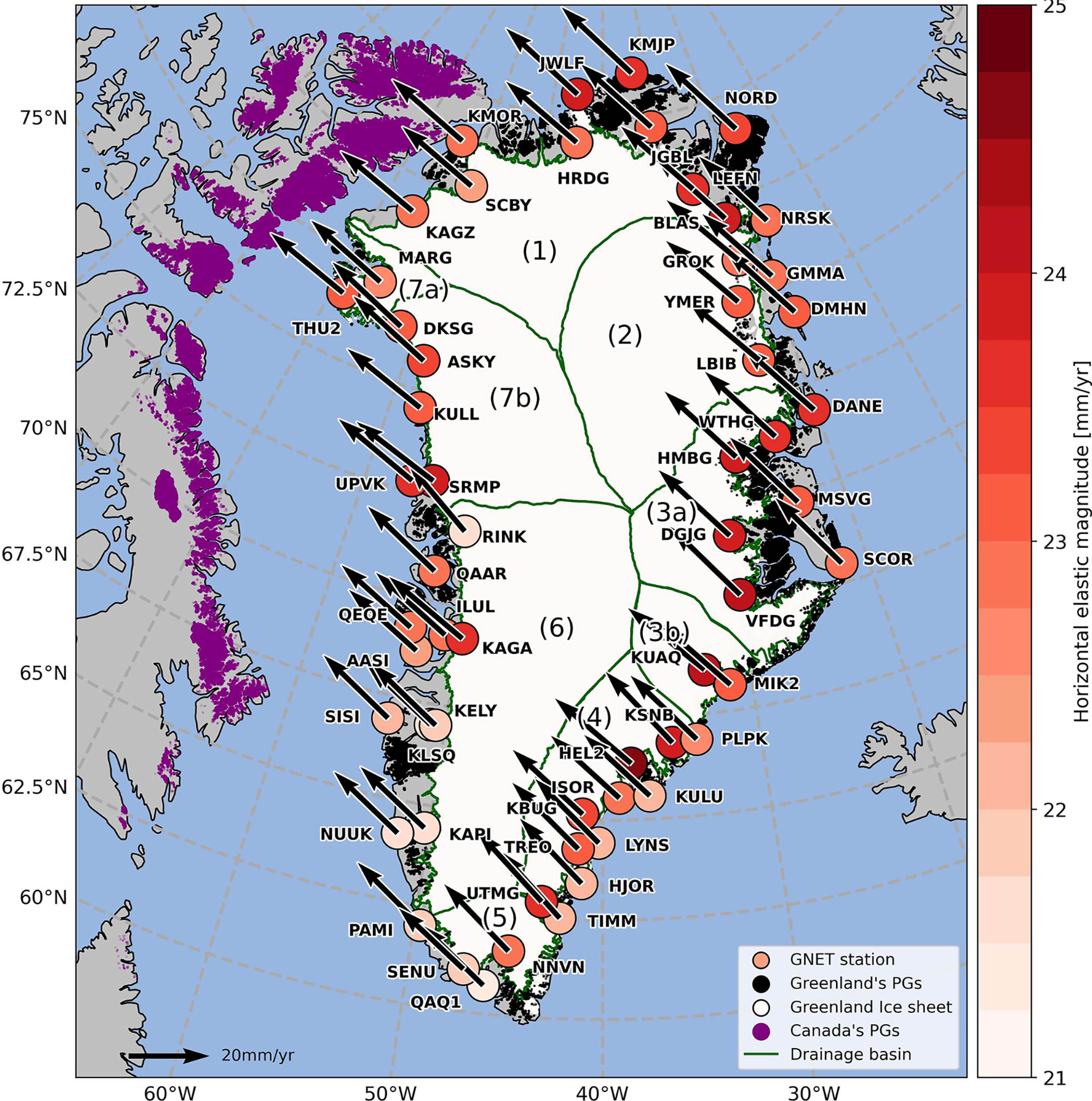
To capture these movements with unprecedented clarity, DTU Space scientists used a network of 58 permanent GNSS (GPS) stations distributed around Greenland.
Over 20 years, those instruments logged the island’s exact position. They also measured the vertical uplift of the crust. Then they tracked horizontal changes that reveal where the land is stretching or contracting.
“There have not previously been such precise measurements of how Greenland is shifting,” said lead author Danjal Longfors Berg, a postdoctoral researcher at DTU Space.
The prevailing assumption, he noted, was that recent melt would mainly stretch the island outward. “But to our surprise, we also found large areas where Greenland is being ‘pulled together,’ or ‘shrinking,’ due to the movements.”
The team paired those modern observations with a geophysical model that spans roughly 26,000 years, linking the end of the last glacial maximum to the present day.
That long lens helps separate the signature of ancient ice loss from the newer signal of accelerated melting in a warming climate.
Where rebound meets resistance
Strip away ice and the crust springs back. That vertical rebound is evident across Greenland, where many GNSS stations show steady uplift. But the new study digs into what that uplift means for surface area. It’s not straightforward.
“The ice that has melted in recent decades has pushed Greenland outward and caused uplift, so the area has actually become larger during this period,” Berg explained.
Picture the crust flexing like a trampoline relieved of weight; the rim shifts outward a touch as the center rises.
At the same time, the lingering, long-period response to post-Ice Age changes is working in the opposite direction: a slow contraction paired with uplift as the mantle continues to flow and rebalance.
The net effect right now, the researchers found, is that Greenland is “overall becoming slightly smaller.” However, that balance could flip as modern melt accelerates.
In other words, Greenland’s footprint is not fixed. It subtly breathes in and out – expanding and contracting in different places – as ancient and modern forces compete.
Greenland’s ice and shifting mass
Beyond the vertical motion, the island is also sliding laterally about two centimeters per year toward the northwest.
That drift reflects how the mantle’s viscous flow and the geometry of ice loss redistribute stress beneath the crust.
As mass shifts, the solid Earth responds like a very slow, very thick fluid. The direction and speed of Greenland’s slide are a fingerprint of how that deep, creeping flow is playing out under the Arctic.
Understanding these motions isn’t just a matter for geophysicists. Land movement complicates surveying, navigation, and geodetic reference frames.
If the “fixed” benchmarks in Greenland are moving fractions of an inch per year, coordinates tied to those benchmarks slowly drift unless continuously updated.
For coastal communities and scientists tracking sea-level change, that matters, too: tide-gauge records and satellite altimetry must account for a rising seabed as well as a rising sea.
“It’s important to understand the movements of landmasses,” Berg said. “They are of course interesting for geoscience. But they are also crucial for surveying and navigation, since even the fixed reference points in Greenland are slowly shifting.”
Earth’s slow dance with ice
Greenland is warming faster than the global average, and its ice sheet is one of the planet’s largest contributors to sea-level rise.
That makes the island a natural laboratory for watching how the solid Earth reacts to rapid climate-driven mass loss.
The DTU Space model – spanning from the late Ice Age to the satellite era – offers a framework to predict how today’s melt will translate into tomorrow’s uplift, stretching, and drift.
The study’s headline can be summed up simply: Greenland is not static. It’s flexing upward, sliding northwest, and deforming horizontally in a pattern shaped by both ancient deglaciation and modern melt.
The opposing forces make Greenland slightly smaller overall, even as some regions stretch larger – a balance that keeps shifting.
If ice loss continues to accelerate, the map of Greenland may, in tiny but measurable ways, change with it.
In a world that often thinks of continents as immovable, this is a reminder that the ground beneath us is always in motion.
The study is published in the Journal of Geophysical Research: Solid Earth.
—–
Like what you read? Subscribe to our newsletter for engaging articles, exclusive content, and the latest updates.
Check us out on EarthSnap, a free app brought to you by Eric Ralls and Earth.com.
—–


