Most complete Roman road map ever created changes historical knowledge of the Empire
For centuries, historians have traced the arteries of the Roman Empire through fragmentary maps and uneven records. Now, a new digital atlas nearly doubles the known extent of Roman roads, charting 185,896 miles (299,160 kilometers) across Europe, North Africa, and the Near East.
Anchored around the early second century – about the year 150 – the project expands the mapped network by roughly 68,700 miles (110,600 kilometers) compared with earlier efforts.
Roman road map changes history

According to the new paper, the dataset covers about 1.54 million square miles (3.99 million square kilometers) and standardizes how Roman roads are recorded. It transforms scattered findings into consistent, testable geospatial evidence.
The work was led by Tom Brughmans, associate professor of classical archaeology at Aarhus University (AU). His research focuses on computational approaches to ancient mobility and connectivity.
This project does more than redraw lines on a map. It creates shared rules for how to track uncertainty, precision, and road hierarchy across 40 modern countries.
“We present Itiner-e, the most detailed and comprehensive open digital dataset of roads in the entire Roman Empire,” said Brughmans.
The network’s expanded reach
The atlas organizes 64,298 miles (103,465 kilometers) as main roads and 121,598 miles (195,670 kilometers) as secondary roads.
Main roads are supported by milestones or high-quality historical evidence, while secondary routes capture local and regional movement.
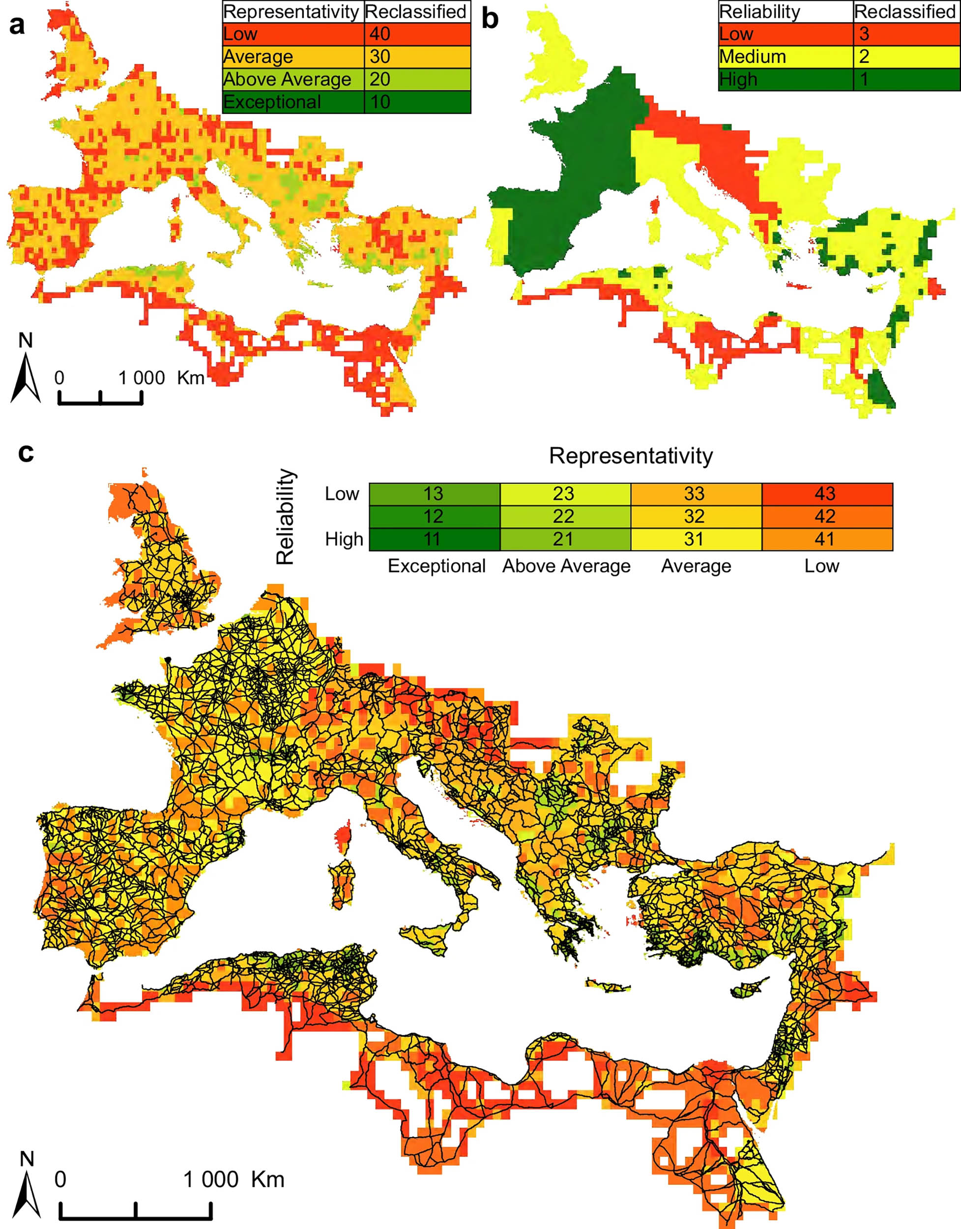
Only 2.74 percent of the network’s length is mapped with high precision. Most of the remainder is classified as conjectured, with a smaller portion marked as hypothetical where evidence is limited.
Coverage grew most in the Iberian Peninsula, Greece, and parts of North Africa. Length also rose because mountain crossings now follow realistic switchbacks instead of straight lines across high terrain.
Building the digital Roman road map
Researchers combined excavation reports, milestones, and historical texts with modern sources. These included topographic maps, maps that show elevation and landforms in detail, and a wide range of historical map series.
They also used remote sensing, observing landscapes from aircraft or satellites, to spot straight alignments, terrace cuts, and old trackways. Line work was traced in Geographic Information Systems (GIS) at fine spatial resolution, then checked against published evidence.
Each road segment has a unique Uniform Resource Identifier (URI) a web address that identifies a specific dataset – and is linked to the Pleiades Gazetteer of ancient places. This makes every segment citable and easy to integrate with other open datasets.
In Egypt’s Eastern Desert, the team used a camel-travel model to reconstruct likely routes between well-dated stations.
This approach computes the least-cost path – the route that minimizes travel effort – over terrain that constrained ancient caravans.
What’s missing from the map
It is a snapshot, not a timeline. The dataset cannot yet show how roads evolved – from construction to abandonment – across different provinces.
“A major challenge is the absence of chronological evidence of the creation and change of roads,” said Brughmans. Future projects will need coordinated dating to track growth and decay of the system.
Mapping uncertainty is not a flaw. It warns users where results are solid and where any model of travel times or trade routes rests on fragile ground.
The authors provide a confidence map, a map showing where data are most reliable, that combines road density, spatial detail, and source quality.
That tool flags regions like northern Italy and the western Danube where new fieldwork could quickly improve precision.
This reshapes ancient history
With consistent coverage, researchers can test ideas about conquest, administration, and cultural exchange. They can analyze how main roads channeled official traffic, while secondary paths connected rural economies.
“This resource is transformative for understanding how mobility shaped connectivity, administration, and even disease transmission in the ancient world,” said Brughmans.
Two changes drove the increase. First, previously ignored regions now include hundreds of local connections that scholars had documented but no one had stitched into a single map.
Second, the new tracing respects terrain. Mountain routes follow passes and zigzags, which lengthen lines compared with earlier straight-line sketches, yet better match how people actually moved.
Explore the Roman road map
You can browse the map, inspect metadata, and test a route-finding beta on the project platform. Each segment lists its sources and a certainty class so you can judge fitness for your question.
Teachers can trace town-to-town journeys and compare them with known marching speeds. Students can explore whether river crossings cluster along certain corridors or whether garrisons concentrate near main road intersections.
Use miles for modern comparison, but always check certainty codes before drawing conclusions. A travel-time model built only on highly certain segments will be more reliable than one that includes hypothetical tracks.
Treat the imperial frontiers with care. In places like the lower Rhine or desert margins, many paths were seasonal or shifted with waterworks and dams, and the map reflects that variability.
Value of open mapping
Because each segment is citable, small regional studies can integrate new evidence directly into the atlas. That means future milestones, bridge discoveries, or excavation reports can refine its geometry without recreating the entire map.
Shared identifiers and open formats also make it easy to link with settlement databases, inscriptions, or climate proxies. Open data promotes reproducible analysis and faster updates.
The Roman road network was vast, but our knowledge of its exact routes remains fragmentary. This new atlas offers both a clearer base map and the transparency to show where evidence is uncertain.
The study is published in Scientific Data.
—–
Like what you read? Subscribe to our newsletter for engaging articles, exclusive content, and the latest updates.
Check us out on EarthSnap, a free app brought to you by Eric Ralls and Earth.com.
—–


