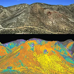
NASA's flying science labs are mapping minerals and deposits from high in the sky
From space exploration to mapping minerals from the skies, NASA’s technology doesn’t just look out toward the stars – it’s also helping scientists understand the land beneath our feet.
A new mapping effort aims to uncover critical minerals here on Earth, using the same instruments that were once pointed at Mars, the Moon, and beyond.
The search is happening right here in the American West. Scientists from the U.S. Geological Survey and NASA’s Jet Propulsion Laboratory (JPL) are leading the effort.
Their partnership is called the Geological Earth Mapping Experiment – or GEMx. It’s possibly the largest airborne spectroscopic survey ever conducted in the U.S., and it’s fueled by decades of NASA technology that was originally built for space missions.
Mapping Nevada’s Mars look-alike
Cuprite, Nevada, looks like another planet. The hills are dry, pale, and scarred by water that once bubbled up from deep underground. Aside from a few Joshua trees, the land could pass for Mars. It’s no coincidence NASA picked this spot to test its sensors.
For over 100 years, prospectors have been drawn to Cuprite’s mineral-rich terrain. More recently, scientists have been using it as a test site for technology designed to analyze minerals in rocky surfaces across the solar system.
“Sensors that discovered lunar water, charted Saturn’s moons, even investigated ground zero in New York City were all tested and calibrated at Cuprite,” said Robert Green, a senior research scientist at NASA’s JPL in Southern California.
Green has been fine-tuning NASA’s instruments in this part of Nevada for decades. His latest mission? Using high-altitude aircraft and advanced sensors for mapping minerals in huge areas of the U.S. In particular, the search is on for mineral deposits that are vital to national security and modern technology.
Mapping minerals from 60,000 feet
The U.S. relies on imports for 50 different critical minerals – materials like lithium and rare earth elements that are used in smartphones, medical devices, and electric vehicle batteries.
To reduce that dependency, the U.S. Geological Survey is trying to locate reliable domestic sources.
NASA’s role is in the air. Flying at 60,000 feet (18,200 meters), its aircraft carry sensors that can detect the molecular makeup of rocks on the ground. These sensors read light patterns far beyond what human eyes can see.

Since 2023, the GEMx campaign has mapped over 190,000 square miles (492,000 square kilometers) of terrain across North America. That’s roughly the size of Spain.
Long partnership with deep roots
This kind of collaboration isn’t new. NASA and the U.S. Geological Survey have worked together since the Apollo era. In the 1960s, USGS geologists created maps of the Moon to help NASA pick safe landing spots for Apollo astronauts.
Before astronauts ever set foot on the Moon, they trained with scientists at the USGS Astrogeology Science Center in Flagstaff, Arizona.
That legacy continues today, with training for the next generation of astronauts heading to the Moon through NASA’s Artemis program.
On the ground today, USGS geophysicist Todd Hoefen and his team collect mineral samples to match with data captured from the air.
Their fieldwork helps confirm that what NASA’s sensors see from the sky matches the reality on the ground.
Tech behind the mineral mapping
At the heart of GEMx is a technology called imaging spectroscopy. NASA’s JPL started developing it back in the 1980s.
The principle is simple but powerful: every molecule reflects and absorbs light in a unique way, like a fingerprint. Imaging spectrometers can detect those patterns.
The key instrument in GEMx is AVIRIS-Classic – the Airborne Visible/Infrared Imaging Spectrometer. It’s about the size of a mini fridge and flies in planes.
Unlike a regular camera that sees just red, green, and blue, AVIRIS sees over 200 different wavelengths, including many in the infrared spectrum.
NASA has used this technology all over the solar system. These spectrometers have studied methane lakes on Saturn’s moon Titan, scanned Pluto’s thin atmosphere, and are now on their way to Jupiter’s moon Europa to search for the building blocks of life.
“One of the cool things about NASA is that we develop technology to look out at the solar system and beyond, but we also turn around and look back down,” said Ben Phillips, a longtime NASA program manager who led GEMx until he retired in 2025.
Old tech meets new
AVIRIS-Classic has flown for more than 30 years. Now, it’s flying alongside its replacement: AVIRIS-5. The new instrument began service in 2025 and is expected to continue the legacy – only with sharper eyes and more power.
Packed into a NASA ER-2 aircraft, which is essentially a high-altitude science lab in the sky, the two instruments are flying over the Western U.S. through fall 2025.
The plane cruises at double the height of commercial jets. The pilot, Dean Neeley, wears a spacesuit due to the thin air at those altitudes.
AVIRIS-5 can zoom in on areas as small as one foot (30 centimeters) across, offering ten times the resolution and data quality of its predecessor.
“The newest generation of AVIRIS will more than live up to the original,” Green said.
Mineral maps on the way
Once the data from these flights is processed and validated, the U.S. Geological Survey will release detailed mineral maps.
These maps could help guide future mining efforts – and reduce U.S. reliance on imported materials.
But for now, the skies over the American West are filled with quiet planes carrying space-age sensors, scanning the rocks below for a better understanding of what we’ve got – and where we still need to go.
—–
Like what you read? Subscribe to our newsletter for engaging articles, exclusive content, and the latest updates.
Check us out on EarthSnap, a free app brought to you by Eric Ralls and Earth.com.
—–


