Scientists discover a giant 'gravity hole' in the Indian Ocean, and now they know the cause
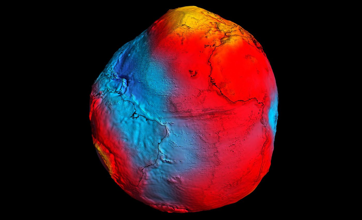
Earth carries an invisible ocean “water level” called the geoid. If only gravity and rotation shaped the oceans, the surface would match that geoid everywhere. However, south of India, the geoid sinks sharply.
At the center of this sunken feature, the geoid lies about 330 feet (100 meters) below the global average, a dramatic signal known as the Indian Ocean Geoid Low (IOGL).

This low water level region raises a clear question: what underground forces could cut such a deep “gravity hole” while leaving a normal-looking seafloor?
The feature sits in the ocean basin without obvious scars. That points to changes inside the planet rather than in the crust. The puzzle centers on how mass moved and settled in the mantle over long periods.
Studying the Indian Ocean Geoid Low
According to the study’s lead author Debanjan Pal, an Indian Institute of Science (IISc) doctoral student, the IOGL was discovered in 1948 during a ship-based gravity survey by Dutch geophysicist Felix Andries Vening Meinesz.
However, the cause of this phenomenon wasn’t known until this study was completed.
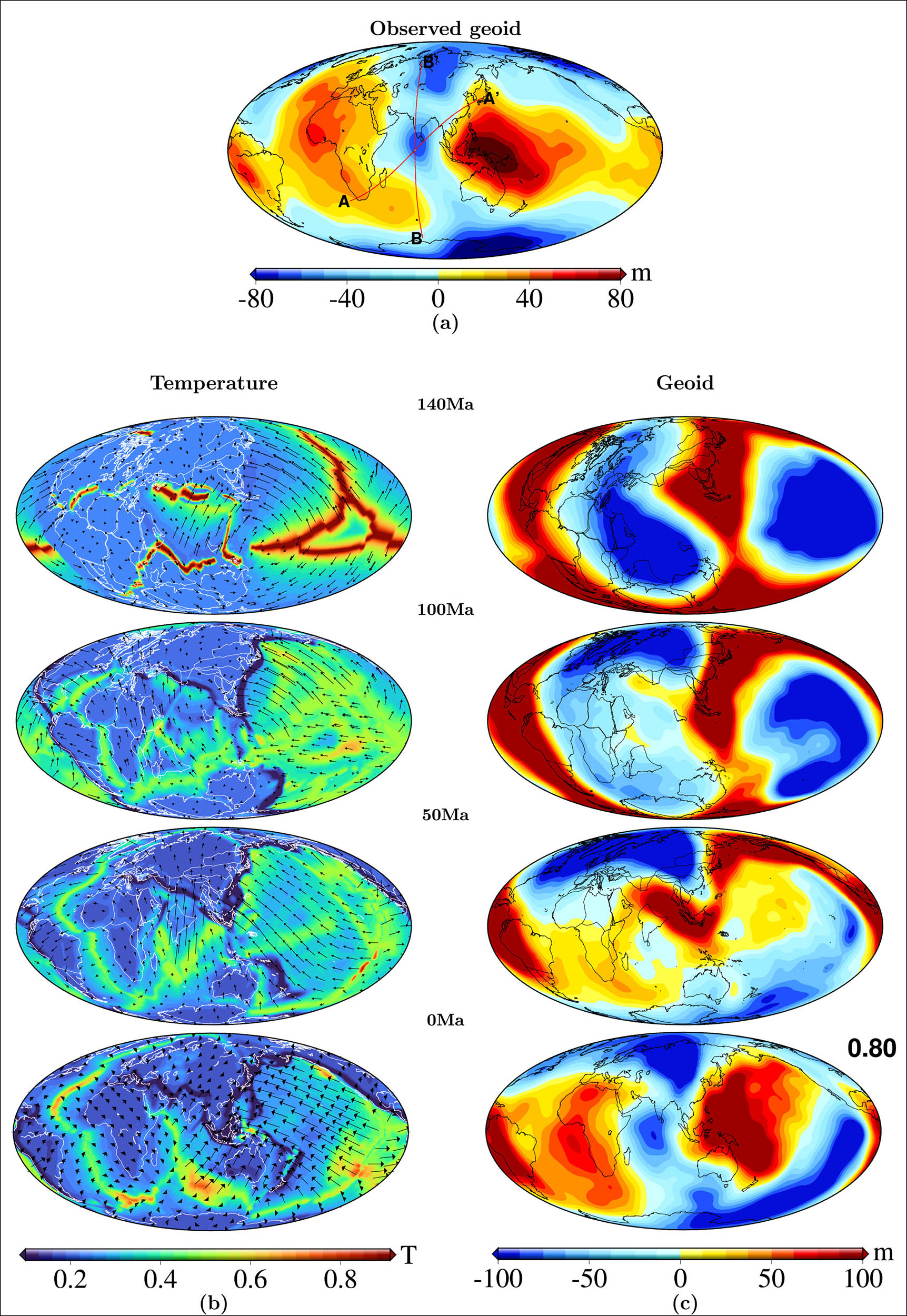
The authors of the new study built computer simulations of mantle flow that span roughly the last 140 million years.
They fed in reconstructions of plate motions, let old oceanic slabs sink, let hotter, lighter upwellings rise, and calculated how those shifts in mass tugged on gravity.
They aimed to match the size and outline of the Indian Ocean Geoid Low using a realistic reconstruction of Earth’s history rather than a single snapshot.
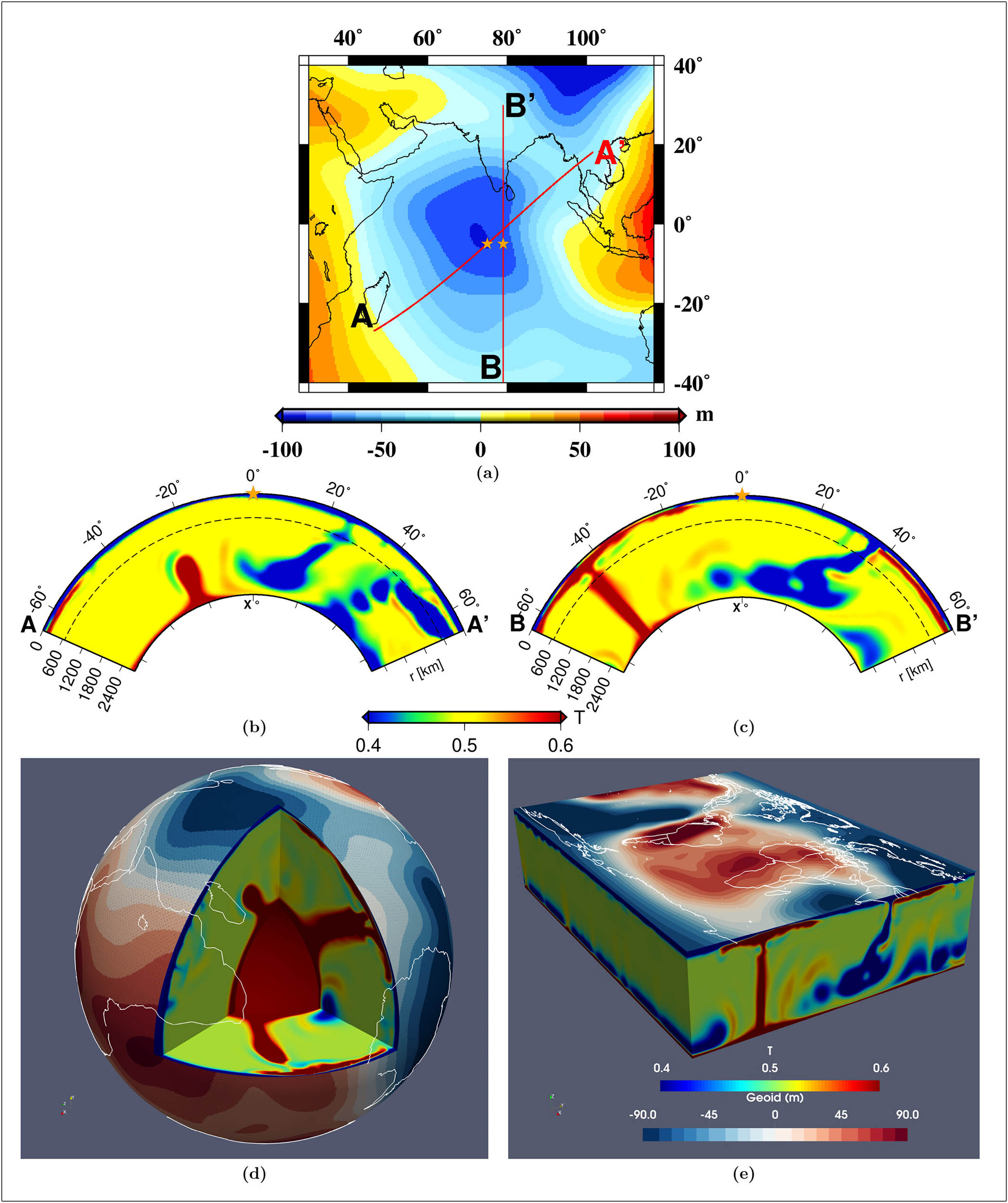
The runs that best reproduced the dip included plumes that rose high – into the mid‑mantle – so their buoyancy could strongly imprint on the gravity field at the surface.
That result links a specific vertical reach of plumes to the strength of the anomaly.
What an ocean geoid low means
Gravity grows stronger where extra mass sits below you and weakens where less dense material sits underneath.
The Indian Ocean Geoid Low ranks as the largest negative gravity anomaly on Earth, which is why the “thumbprint” jumps out on maps.
Satellites track small changes in their orbits caused by gravity and use those changes to chart geoid highs and lows with high precision. The seafloor there looks ordinary, so the signal points deeper.
In a perfect world with no winds, currents, or tides, the ocean surface would line up with the geoid. Over the geoid low, that surface would sit far below the global average.
In the real ocean, circulation blurs the picture, but the negative geoid signal remains strong – the “gravity hole” measured today.
Deep mantle under Africa–Indian Ocean
The models trace the story back to the Tethys Ocean, the body of water that once lay between India and Eurasia.
As ocean crust dove into subduction zones, its cold, dense slabs plunged and piled up near the margin of a hot, low‑density region in the deep mantle beneath Africa.
Geophysicists often call that hot region a “large low-shear-velocity province,” where seismic waves travel more slowly because the mantle is hotter and less dense.
That broad setup matters. The sinking slabs pressed against the deep structure beneath Africa and helped spawn buoyant plumes that drifted eastward and upward beneath the Indian Ocean.
Together, the heavy slabs and lighter plumes rearranged where mass sits inside Earth. That reshaped the gravity field in a way that matches the magnitude and outline of today’s Indian Ocean Geoid Low.
Timing that fits Earth’s history
The computer simulations suggest the first plumes capable of shaping the geoid low rose roughly 20 million years ago.
That lag follows the path you would expect: slabs need time to descend into the lower mantle, interact with the hot African province, and set up steady upwellings.
India’s rapid northward motion across the ocean and its ultimate collision with Asia set the chain in motion by feeding subduction over tens of millions of years.
Not all models agree
Earlier work that focused only on present-day mantle structure hinted that warm anomalies in the mid‑ to upper mantle mattered, but it left the origin of that pattern unclear. Some “instant” models placed the cause right under the geoid low.
The new results show a different route: a time‑evolving interaction between long‑lived slabs and deep, hot mantle beneath Africa that eventually organized plumes toward the Indian Ocean and produced the observed low.
Researchers combine three lines of evidence to study hidden mantle structure. Gravity data reveal where mass stands high or low.
Seismic waves from earthquakes scan the interior; slower waves highlight hotter, lower‑density regions while faster waves outline cooler, denser slabs.
Geodynamic models test whether a proposed interior layout and history can produce the same gravity signal observed at the surface.
When all three agree on a pattern, confidence rises that the interior picture is on the right track.
More questions need answers
Sharper images of the mantle beneath the Indian Ocean will help.
Denser coverage from seismic stations and more earthquake recordings across the region can refine the depth and shape of the plumes and the edges of the deep African province.
With better coverage, modelers can tighten the link between where upwellings peak and how strongly they affect the geoid.
Why the Indian Ocean Geoid matters
This work connects surface plate motions, deep‑mantle circulation, and modern gravity measurements in one consistent picture.
It explains why a normal‑looking patch of seafloor sits above the deepest geoid dip on the planet and shows how mass movements over long spans of time produce the signal satellites see today.
The chain runs from ancient ocean crust sinking into the mantle to hot upwellings nudged eastward to a gravity signature that stands out in the ocean’s “level” today.
The full study was published in the journal Geophysical Research Letters.
—–
Like what you read? Subscribe to our newsletter for engaging articles, exclusive content, and the latest updates.
Check us out on EarthSnap, a free app brought to you by Eric Ralls and Earth.com.
—–


