
Massive structures discovered in the North Sea could change oil production and CO2 storage
Far below the seafloor of the northern North Sea, geologists mapped strange hills buried under younger sediments. The University of Manchester research team calls the sand bodies beneath the mounds “sinkites,” and the blocks of uplifted ooze “floatites.”
These features are about .6 miles (one kilometer) across and occur where the rock layers should look simple and flat.

However, the data show that the buried mounds and the sand beneath them record an unusual reshuffling of the sediment stack.
These mounds appear to have sunk downward, pushing aside the older, lighter, and softer materials beneath them.
This behavior adds a new, large‑scale mechanism by which Earth can rearrange layers after they are deposited, instead of leaving them fixed in the order they first formed.
Layers that disobeyed the rules
These buried landforms sit in rocks laid down during the Oligocene and Miocene epochs beneath the North Sea.
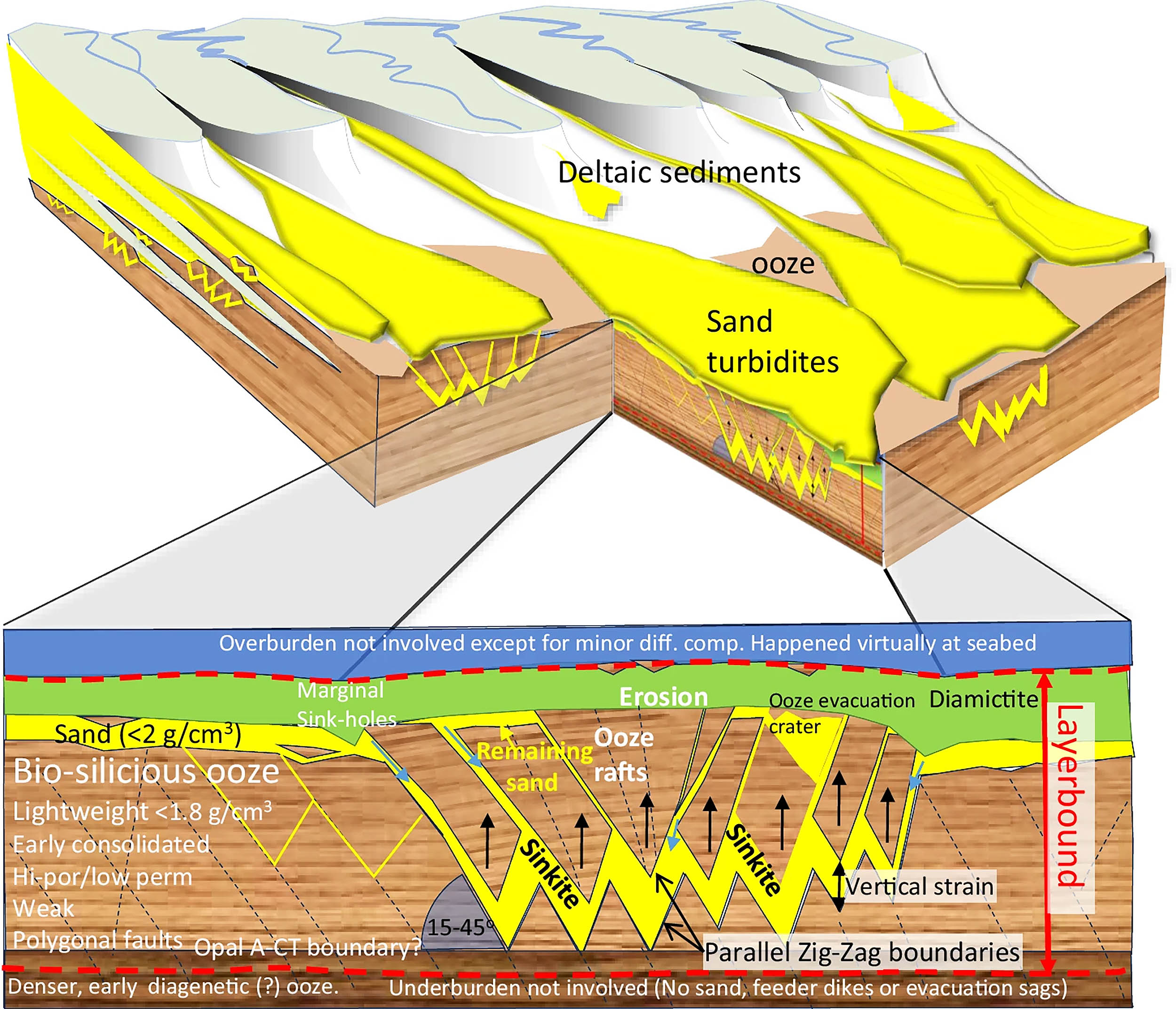
In this region, a light, porous, silica‑rich mud described as biosiliceous “ooze” forms a unit known as the upper Hordaland Group.
Later, sand‑rich deposits called the Utsira Group settled on top. At the boundary between them – the mid‑Miocene unconformity – hundreds of puzzling mounds and ridges appear.
Those epochs span tens of millions of years, and in that time rivers and currents carried huge volumes of mud and sand into the basin, slowly building up the stack of sediment that now lies far below the present seafloor.
Sinkites and buried hills
To understand these “sinkite” structures, the research team used basin‑scale 3D seismic imaging across tens of thousands of square kilometers of the basin floor.
This method sends sound waves into the subsurface and records their echoes, allowing scientists to build detailed images of the buried hills and align them with well logs, photos of drill cuttings, and mineral analyses from many boreholes.
“This discovery reveals a geological process we haven’t seen before on this scale,” explained lead author Professor Mads Huuse from The University of Manchester.
“What we’ve found are structures where dense sand has sunk into lighter sediments that floated to the top of the sand, effectively flipping the conventional layers we’d expect to see and creating huge mounds beneath the sea.”
Physics of sinking sand
During the Miocene, earthquakes shook this part of the basin and briefly liquefied the shallow sand layer above the ooze as the grains lost strength and flowed more easily.
That unstable arrangement, with a denser layer resting on a lighter one, set up a Rayleigh–Taylor instability. As a result, heavier material sank while lighter material rose.
Mobile sand sank through existing cracks – especially along a honeycomb network of “polygonal faults” – and pushed rigid blocks of ooze upward into the buried hills.
As the sand moved downward, it formed the sinkites that now underpin the mounds, leaving a signature “shark’s‑mouth” zig‑zag geometry where sand fills the intersecting fracture planes.
Mid‑Miocene tectonic activity supplied the necessary earthquakes, and water squeezed from the compacting ooze probably helped mobilize the sand.
“This research shows how fluids and sediments can move around in the Earth’s crust in unexpected ways,” notes Professor Huuse.
“Understanding how these sinkites formed could significantly change how we assess underground reservoirs, sealing, and fluid migration – all of which are vital for carbon capture and storage.”
Clues written in rock
In seismic profiles, sand‑filled fractures link the sand under the mounds to younger Utsira Group sand above, and the images clearly show the “plumbing” that allowed sand to descend.
At the Visund mound, the intrusive sand beneath the ooze connects through such fracture zones to nearby younger sand.
Continuous reflectors below the hills, the lack of “feeder” dikes or evacuation sags, and the absence of large landslide head‑scarps and toe‑compression features all argue against sand being injected upward from deeper layers or the mounds forming as slide debris.
The serrated, zipper‑like margins of the structures, plus the close match between mound patterns and the polygonal fault network, fit a sinking‑sand, rising‑ooze origin better than those alternatives.
These lines of evidence build a coherent case for buoyancy‑driven stratigraphic inversion that operated near the seafloor and locally bent the law of superposition, which normally keeps younger layers on top of older ones.
Lessons from sinkites and floatites
This mechanism matters beyond this single basin because it changes how geologists read the rock record in basins that stack low‑density mud beneath denser sand.
If layers can locally swap positions after deposition, then maps that show which rock is older or younger need to allow for zones where younger sand has undercut older mud rather than simply lying above it.
Geologists have not documented this distinct, large‑scale gravitational reshuffling before.
This work also has practical importance for subsurface projects. The mounds and sinkites involve a lot of sand, and sand layers form the reservoir rocks that store fluids such as oil, gas, or injected CO2.
Understanding the pathways carved by that inversion can improve predictions about how those fluids move.
That knowledge can help engineers assess storage integrity, seabed engineering risks, and other geohazards in places with similar geology where earthquakes could trigger comparable inversion near the seabed.
“As with many scientific discoveries there are many skeptical voices, but also many who voice their support for the new model. Time and yet more research will tell just how widely applicable the model is,” Professor Huuse concludes.
The full study was published in the journal Communications Earth and Environment.
—–
Like what you read? Subscribe to our newsletter for engaging articles, exclusive content, and the latest updates.
Check us out on EarthSnap, a free app brought to you by Eric Ralls and Earth.com.
—–


