Submarine lost since 1917 is found under more than 1,300 feet of water
A World War I era U.S. Navy submarine now rests quietly more than 1,300 feet (396 meters) below the Pacific, west of San Diego. The USS F-1 sank on 12/17/1917 after a collision during a training run, and 19 sailors died, according to Navy records.
A recent deep-ocean mission used modern tools to map the wreck in crisp detail, without disturbing it. The mission doubled as a training cruise for pilots and engineers who operate some of the most capable undersea vehicles in the world.
Finding the USS F-1

Bruce Strickrott, from Woods Hole Oceanographic Institution (WHOI), helped lead piloting on the expedition.
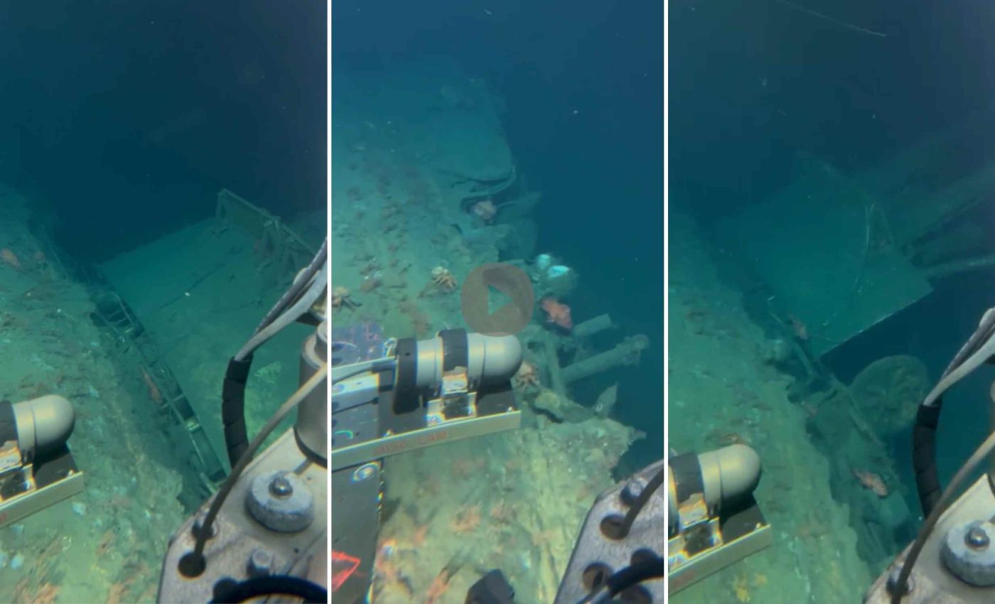
He and partner teams documented the submarine’s hull and surrounding seafloor with high resolution video and photos.
The human-occupied vehicle Alvin can reach about 4 miles (6.5 kilometers) deep, which puts most of the seafloor within reach of its cameras.
That capacity made it possible to observe the site directly and plan safe, careful passes over sensitive features.
The first views showed that the submarine is still relatively intact, lying on one side of its hull, with key features still visible. Teams also noted seafloor life that has colonized the wreck over time.
How USS F-1 images were captured
The crew stitched thousands of overlapping images into precise 3D shapes using photogrammetry, a method that turns many pictures into accurate measurements. Those models help researchers estimate dimensions and track changes at the site over time.
An autonomous underwater vehicle called Sentry cruised low and steady to map the area with sonar before Alvin arrived.
Sentry is rated to operate down to about 19,685 feet (6 kilometers) and can run long, pre-planned survey lines with high stability. This is ideal for seafloor mapping and imaging.
After Sentry’s reconnaissance, the human-occupied vehicle (Alvin) flew slow, deliberate patterns over the wreck. Pilots balanced visibility, distance, and safety to avoid stirring sediment or contacting the hull.
The technology at work
A ship-mounted multibeam sonar built a wide-area map from the surface. That map guided Sentry’s lower altitude passes for finer detail, and helped the team plan Alvin’s flight lines.
Photogrammetric models capture the submarine’s dimensions within small margins of error when images overlap well and light is even. Those constraints pushed the team to use steady speeds, stable altitudes, and consistent camera settings during each run.
History of the USS F-1 submarine
F-1 went down in heavy fog when her sister boat, F-3, struck her broadside off Point Loma. The Navy Director’s historical H-gram recounts that F-1 sank within seconds and five topside sailors survived while 19 were lost.
The site is a war grave and a protected Navy wreck. That status shapes how scientists plan surveys, which means non-contact documentation and a leave-in-place approach to anything observed.
Respect led the expedition to hold a brief remembrance aboard the research vessel over the wreck site. A crew member tolled the ship’s bell 19 times as names were read.
Training with purpose
This cruise sharpened pilot skills for complex underwater habitats where currents, slopes, and visibility can change quickly.
Mapping a wreck at depth requires smooth coordination among bridge officers, vehicle pilots, sonar operators, and image specialists.
The work also trains the next wave of undersea engineers on safe procedures, navigation checks, and data quality control.
Confidence in these skills matters when missions shift to active faults, vents, and other sites where good decisions protect both people and instruments.
High-def models of USS F-1
High fidelity 3D models allow experts to measure hull thickness, openings, or damage patterns without touching the site. Repeat surveys can flag changes caused by corrosion, gravity, or biology.
Detailed shape files also help historians interpret how the collision unfolded and where water likely rushed in.
Combined with archival logs and survivor accounts, the geometry can test hypotheses with numbers instead of guesswork.
These data support education and museum work as well. Curators can build accurate exhibits or virtual tours that preserve context and scale.
Tools behind the scenes
Alvin’s pressure sphere, thrusters, and life support allow three people to spend hours on the bottom. The sub’s manipulator arms stayed out of the way on this mission, because the team chose visual surveys only.
Sentry’s pre-programmed tracks covered the area efficiently, collecting images and sonar swaths that overlapped. That redundancy is vital for clean mosaics and consistent 3D reconstructions.
Both vehicles send navigation data to align imagery with the seafloor map. Cross checks between instruments catch drift or distortion before it becomes a problem.
The same methods can document other war graves and historic downed aircraft without disturbing them. Accuracy improves as cameras, navigation sensors, and processing software advance.
More expeditions will use this playbook on complex terrain where cliffs, boulders, or wreckage make flying tricky. The skills honed here translate directly to research on hazards, ecosystems, and resources.
All images and videos can be viewed here…
—–
Like what you read? Subscribe to our newsletter for engaging articles, exclusive content, and the latest updates.
Check us out on EarthSnap, a free app brought to you by Eric Ralls and Earth.com.
—–


