Tropical Cyclone Seroja approaches Western Australia
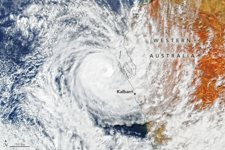
Tropical Cyclone Seroja approaches Western Australia Today’s Image of the Day from NASA Earth Observatory features Tropical Cyclone Seroja hours before it made landfall in Western Australia on April 11, 2021.
The category 3 storm ripped through 600 miles of land, knocking down trees and damaging buildings along its southward path, according to NASA.
Seroja made landfall south of the resort town of Kalbarri, where it damaged about 70 percent of the structures. Wind gusts of up to 100 miles per hour were the strongest in this region in about 50 years. Western Australia (abbreviated as WA) is a state occupying the western 32.9 percent of the land area of Australia excluding external territories. It is bounded by the Indian Ocean to the north and west, and the Southern Ocean to the south, the Northern Territory to the north-east, and South Australia to the south-east. Tropical Cyclone Seroja approaches Western Australia Western Australia is Australia’s largest state, with a total land area of 2,527,013 square kilometres (975,685 sq mi), and the second-largest country subdivision in the world, surpassed only by Russia’s Sakha Republic. As of 2017, the state has about 2.6 million inhabitants – around 11 percent of the national total – of whom the vast majority (92 percent) live in the south-west corner.
Before arriving in Australia, Seroja was particularly destructive and devastating in Indonesia. Torrential rainfall caused flashed flooding and landslides that wiped out bridges, trees, and structures. More than 160 people were killed and 22,000 people have been displaced.
The image was captured by the Visible Infrared Imaging Radiometer Suite (VIIRS) on the Suomi NPP satellite. Image Credit: NASA Earth Observatory
—
By Chrissy Sexton, Earth.com Staff Writer


