AI drones discover dozens of 'ghost nets' hidden on remote beaches
A quick flight over the Gulf of Carpentaria now reveals what once lurked unseen: almost one abandoned fishing net for every stretch of shoreline the length of eleven football fields.
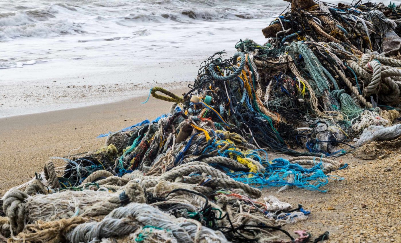
PhD candidate Aliesha Hvala at Charles Darwin University’s North Australia Center for Autonomous Systems (NACAS) says the drone based survey of the Anindilyakwa Indigenous Protected Area has covered roughly 52 mi of coastline and located seventy two ghost nets, some as small as 20 inches and others topping 16 feet.
Why ghost nets matter

Every year an estimated 640,000 tons of lost or discarded fishing gear drifts through the world’s oceans, snagging everything from coral heads to endangered turtles.
Ghost gear now makes up as much as 46 percent to 70 percent of all large plastic debris at sea, according to the UN Food and Agriculture Organization (FAO).
Entanglement by these silent traps kills whales, dolphins, and dugongs, and the nylon and polyethylene fibers break down into microplastics that move up the food chain.
The Gulf’s remote headlands, mangrove creeks, and sea grass meadows shelter dugong nurseries and nesting flatback turtles, so a single stranded trawl net can undo years of conservation work.
From chopper to controller
“With CDU, we’ve successfully used drones to map the most affected beaches within the IPA, enabling more efficient planning and targeted net removal,” said Kirsten Eden, Land & Sea Manager for the Anindilyakwa Land Council.
Helicopter patrols once scanned this coast, but flight time, fuel, and weather windows turned monitoring into an expensive gamble.
A six rotor UAV that fits in a pickup bed now does the same job for the price of a tank of gas and a few charged batteries, and it can fly during breaks in the wet season storms when aircraft stay grounded.
Once nets are tagged from the air, the Ranger crew steers the 36 foot purpose built vessel Jarrangwa to the nearest landing, sets up a portable winch, and hauls the gear aboard for safe disposal.
High tech, local hands
Survey work is paired with training, and ten Anindilyakwa rangers have earned the nationally recognized Certificate III in Aviation (Remote Pilot) that meets Civil Aviation Safety Authority rules.
“I wasn’t very comfortable doing it, but I had the right people around me to overcome that and I’m very grateful,” said ranger Louise Mountford after finishing the course.
Building these skills on Country means drone batteries get swapped next to mangroves instead of at distant city airports, keeping knowledge and jobs in the community.
It also shortens response time; a net reported on Monday can be removed by Wednesday before tides rebury it or refloat it onto a reef.
How AI finds buried ghost nets
High resolution imagery is run through an onboard algorithm trained to flag the spectral signature of green or orange twine against sand and spinifex.
“High resolution images combined with precise GPS coordinates of ghost nets has greatly improved the efficiency of trip planning,” said Aquatic Biosecurity Officer Benjamin McArdle.
Remote sensing researchers note that pairing drones with machine learning classifiers can pick up plastic items smaller than three inches and distinguish gear fragments from driftwood or rock shadows.
Some nets resemble icebergs, with only a palm sized knot visible above the sand while yards of mesh hide below, so the team carries shovels and a battery powered capstan to winch out the buried mass.
Cleaning up the ghost nets
The initial survey has already pulled more than thirty tons of netting, floats, and rope off the beaches, freeing sandstone ledges where turtles haul out to nest.
Another broad scale drone campaign begins later this month, timed for the southeast trade winds that wash gear ashore from fisheries in Indonesia, Papua New Guinea, and northern Australia.
Eden warns that sustained success depends on long term gear, data storage, and refresher training funds, because batteries die faster in tropical heat, and software needs regular updates to stay accurate.
Federal Ghost Net Innovative Solutions grants currently foot the bill, but rangers are exploring carbon credit partnerships that reward habitat protection and create an independent revenue stream.
Template for global coastlines
From Hawaii to the Galápagos, coastal managers are watching the Groote Archipelago project as a field test of low cost aerial surveillance married to Indigenous stewardship.
Lightweight drones can be packed onto small boats, driven inland on all terrain vehicles, and even recharged with portable solar panels, letting crews cover beaches that satellites miss because of cloud cover.
Global fisheries bodies are rolling out electronic tags and mandatory gear marking rules so nets can be traced back to owners, while local drone teams provide the fast detection that turns regulations into retrieved plastic instead of paperwork.
Plastic production is projected to triple by 2060, yet the lessons from this remote stretch of Northern Territory show that swift technology adoption, community ownership, and clear funding paths can keep that future from becoming a tangled one.
—–
Like what you read? Subscribe to our newsletter for engaging articles, exclusive content, and the latest updates.
Check us out on EarthSnap, a free app brought to you by Eric Ralls and Earth.com.
—–


