Almost half of this state is on the brink of ecological collapse
Queensland, Australia, has added new national parks in recent years, but a new analysis shows that tree and habitat loss is still outpacing protection.
A team led by Dr. Ruben Venegas-Li at The University of Queensland found the state has lost 21 percent of its original woody vegetation, a decline driven by decades of large-scale clearing of native trees and shrubs.

Using data to track change from 2000 to 2018, researchers found that one fifth of all historical loss occurred within that 18-year window – even as park coverage nearly doubled.
The contrast underscores a central point: increases in protected land do not necessarily mean nature is safer on the ground.
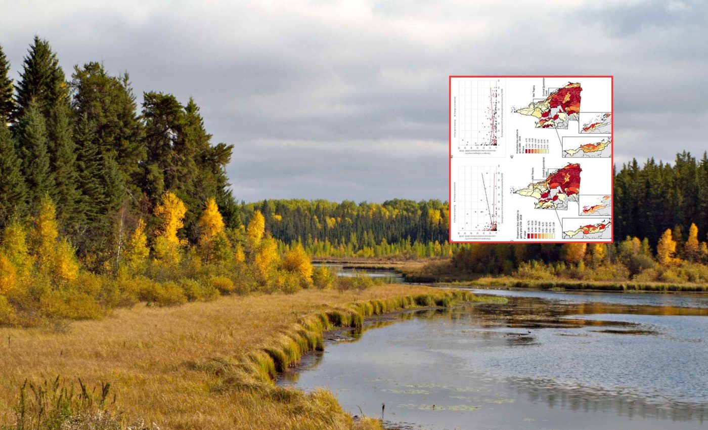
What the new analysis shows
The authors focused on how much habitat was cleared versus how much was secured. They applied a conservation balance sheet, a method that compares protection gains against losses to judge real progress.
This approach tells us whether parks are keeping pace with clearing, not just whether there are more parks.
They measured parks using CAPAD, Australia’s official protected area database. It shows where protected land is actually located, which lets the analysis check if protection overlaps with the places under the most pressure.
Parks alone can’t save tree loss
Many new parks were declared in far northern regions with lower tree clearing pressure. The most heavily cleared landscapes, where nature is most at risk, saw little new protection.
“But this claim does not stand up to scrutiny,” said Dr. Venegas-Li. He was referring to the idea that adding parks alone is keeping Queensland’s nature safe.
The analysis shows a mismatch between losses and gains. Roughly 20 percent of vegetation was cleared, while only about 10 percent was placed under protection during the same period.
Counting new park acres without counting continued clearing paints a false picture. The net outcome is negative if bulldozers remove habitat faster than protection adds it.
Communities feel the strain
Forest loss affects more than wildlife. It also puts pressure on nearby towns that depend on healthy landscapes for water security, stable soils, and local climate conditions, especially during long dry periods.
These changes can disrupt farming, reduce water quality, and increase erosion in places already struggling to manage land pressure.
Communities living near rapidly cleared regions face higher risks from heat, dust, and flooding because natural vegetation helps regulate these extremes.
The study highlights that these local impacts often go unnoticed in statewide reporting, even though they shape the daily experiences of people who rely on the land.
Where the risk is highest
The study mapped risk across subregions – areas with similar climate and biology that help target action. By 2018, the Brigalow Belt, New England Tablelands, and parts of the Mulga Lands stood out as crisis zones.
Nearly two thirds of subregions had less than 10 percent of their woody vegetation protected. Forty-four percent were rated high or very high risk of further loss, a warning sign for many local species.
Heavily cleared districts continued losing habitat for grazing and infrastructure, which drives fragmentation, breaking habitat into smaller, isolated patches that strain wildlife. Small, cut-up remnants make it harder for species to feed, breed, and move.
Cape York and the Wet Tropics gained more protection, but they were already relatively secure. Meanwhile, several southern and central subregions with long clearing histories saw little protection added.
A path to tree loss recovery
Stopping clearing in the worst hit places would bring immediate benefits. A targeted moratorium – a temporary halt on certain clearing, would protect the last remnants while longer term plans are set.
Protection should expand in depleted environments where it is scarcest, not only in photogenic or remote places. Better compliance and enforcement are needed so rules have real bite on the ground.
Restoration should be funded in landscapes that have already lost a lot of habitat. Rebuilding tree cover and reconnecting patches can lift survival odds for many species.
Countries endorsed target to conserve 30 percent of land and sea by 2030. Reaching that goal requires more than park totals, it requires protecting the right places for biodiversity, the variety of living organisms in an area.
Revealing the real losses
Queensland’s first change report under the 2018 baseline explains why older and newer numbers cannot be compared directly. Because the method shifted to a new baseline, the study ends at 2018 to keep apples-to-apples comparisons.
This caution matters for honest reporting. It is easy to claim progress if you count only gains, but the balance sheet shows the truth when both sides are measured.
SLATS continues to monitor clearing annually, which gives decision-makers a clear view of where tree and habitat loss is still rising. Pairing those data with CAPAD allows planners to place protection and restoration where it offsets risk.
The same logic can guide other regions facing clearing pressure. Track both sides, protect what is left, and restore what has been degraded.
The study is published in Environmental Research Letters.
—–
Like what you read? Subscribe to our newsletter for engaging articles, exclusive content, and the latest updates.
Check us out on EarthSnap, a free app brought to you by Eric Ralls and Earth.com.
—–


