Glaciers are slowly sculpting and transforming the planet as they melt
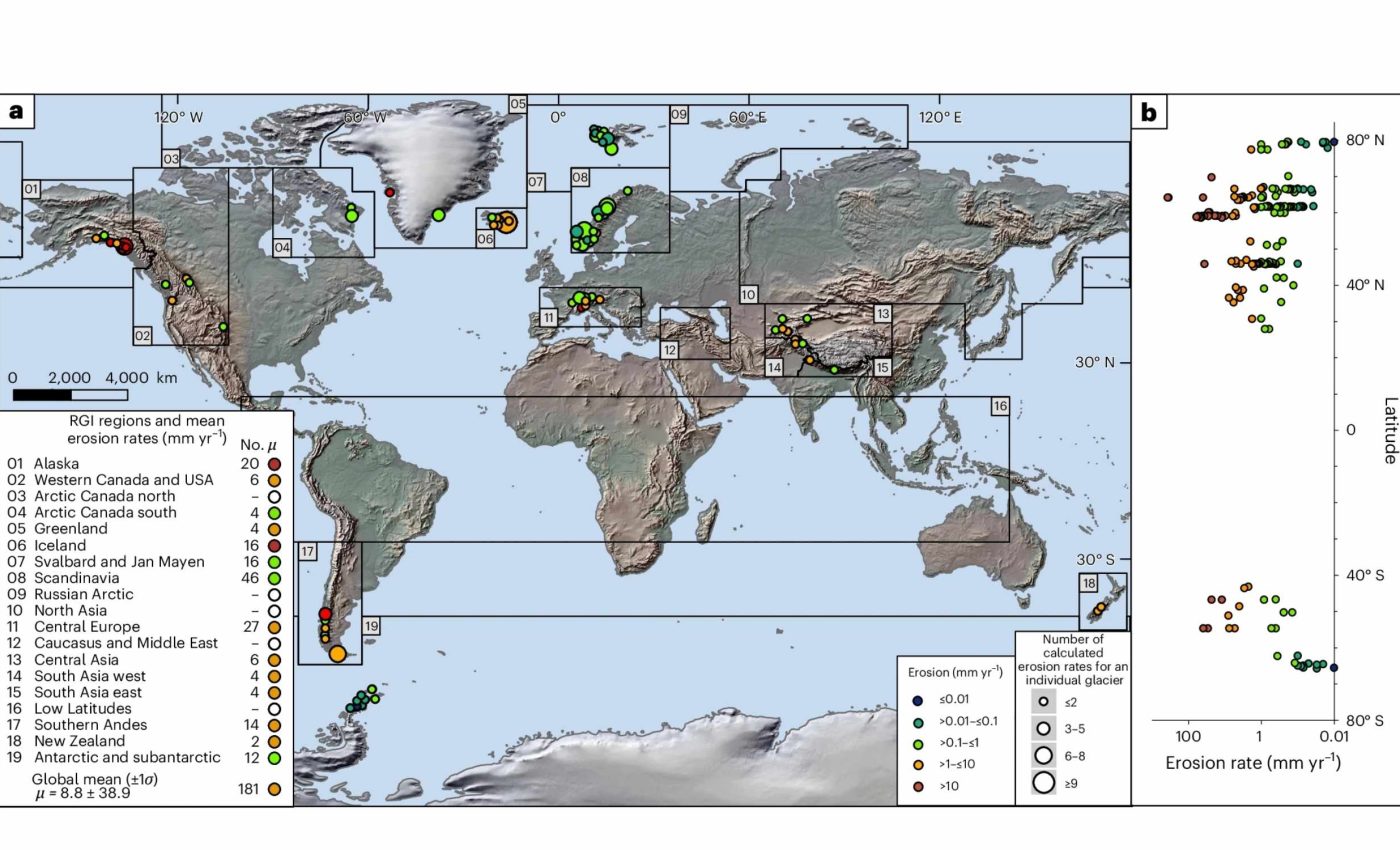
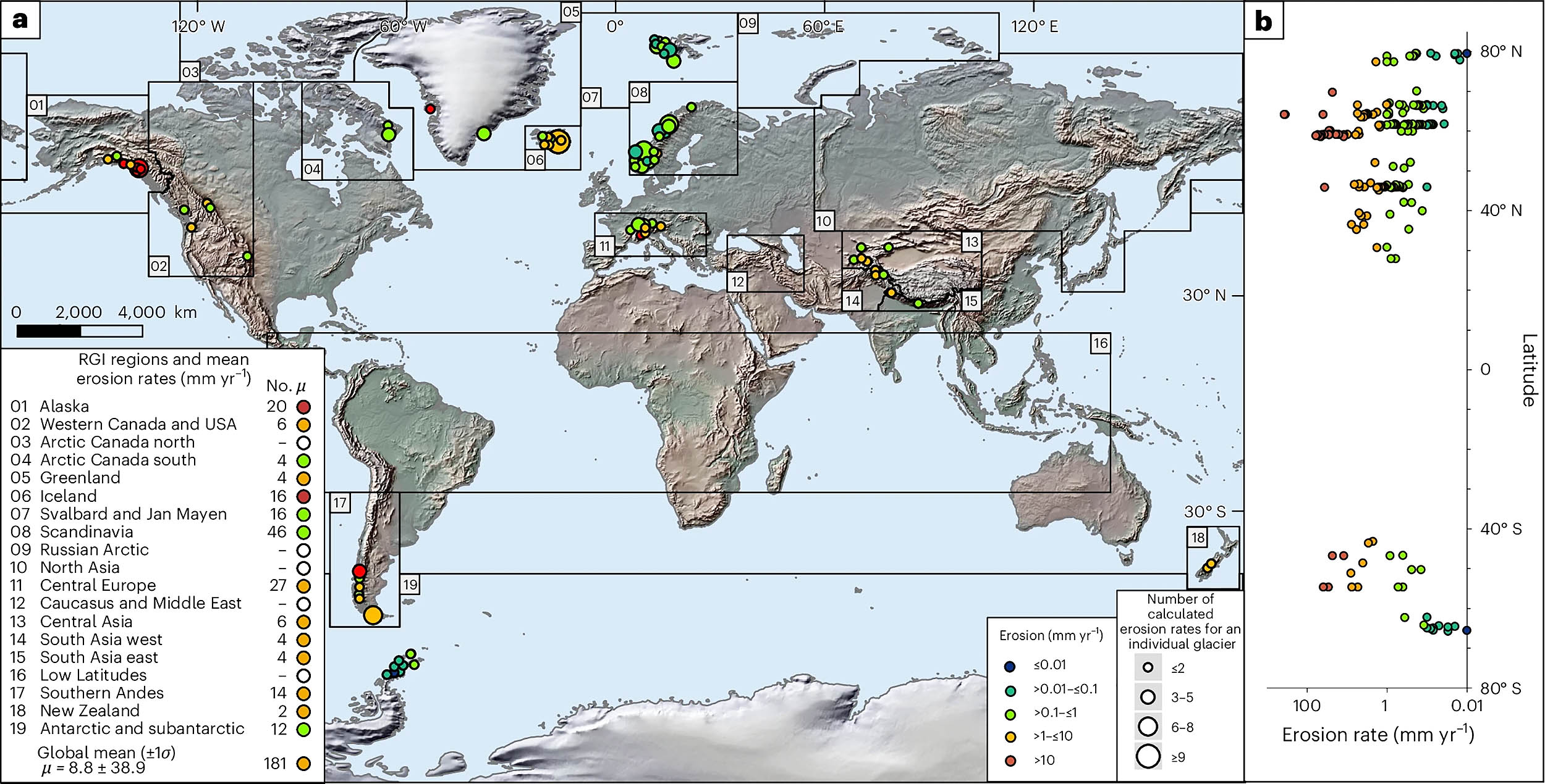
Melting glaciers are causing land erosion around the globe, wearing down bedrock at rates that usually fall between about 0.0008 and 0.11 inches (0.02 to 2.8 millimeters) per year. That single range captures the pace for 99 percent of the world’s ice masses, according to new estimates.
A global team used machine learning to scale those rates up to more than 180,000 glaciers. The work shows where modern ice is quietly reshaping bedrock and where it barely makes a dent.
Glacier erosion of Earth’s landmass

Lead researcher Sophie L. Norris from the University of Victoria, and colleagues, built statistical equations that predict how fast a glacier erodes its bedrock. They applied the equations to most of Earth’s mapped glaciers and then tallied the results for a global picture.
In the new study, the team reports that 99 percent of glaciers erode within a narrow band when measured year to year. The analysis also estimates rates for 85 percent of modern glaciers, a scope not previously possible.
“The conditions that shape glacier erosion are more complex than we realized. Our analysis shows that temperature, subglacial water, rock type, and heat from Earth’s interior all strongly influence erosion rates,” said Norris.
When scientists talk about glacier erosion they are measuring how ice abrades and plucks bedrock. Those processes set the depth and shape of valleys and the volume of sediment that rivers carry downstream.
How fast do glaciers erode
The predicted rates run from roughly 0.0008 to 0.11 inches (0.02 to 2.8 millimeters) per year. That span captures slow, cold glaciers and faster, wetter systems without stacking a maze of separate comparisons.
Some regions contribute far more of the total rock removed because they host many glaciers. Alaska, the Canadian Arctic, Greenland, Scandinavia, the southern Andes, and parts of High Asia account for a large share of the global volume.
Those regional differences do not mean velocity tells the whole story. The data show that fast sliding alone does not dominate in any glacier setting examined.
Why glacier erosion rates vary
Earlier research often linked erosion rate to sliding speed. That view captured part of the physics, yet it missed key climate and geology factors.
Precipitation stands out in the new work because more snowfall leads to more meltwater at the bed. That meltwater can move sediment out of the way, letting ice contact bedrock more often.
Elevation and latitude matter because they shape temperature and pressure conditions at the base. Warmer basal ice that is close to the melting point tends to erode more efficiently than colder, rigid ice.
The team used elastic net regression, a model that balances simplicity and accuracy by shrinking variables, to weigh many predictors at once. That approach reduces overfitting and copes with variables that overlap.
Among the strongest predictors were precipitation, glacier elevation, glacier length, latitude, and the rocks beneath. Local geothermal heat flux – heat moving upward from Earth’s interior – also helped explain where erosion is more active.
Velocity still plays a role in some land terminating glaciers. It simply is not the top predictor when climate and geology are added to the mix.
How the study was done
The equations were calibrated with erosion rates compiled from around the world. Those measurements came from sediment carried by meltwater, volumes stored near glacier fronts, and rare direct readings under ice.
Surface speeds and thickness came from satellites and airborne mapping. The group linked those observations with climate records and global maps of bedrock types.
They then ran the model across a near global glacier catalog. Antarctica was excluded because key inputs are still incomplete there.
Turning numbers into a global picture
Taken together, the modeled glaciers remove tens of billions of tons of rock per year. That volume is the product of modest rates spread over very large areas.
Most of the predicted erosion occurs at mid- to high-latitudes where modern ice is extensive. Mountain belts with heavy snowfall and steep valleys also stand out.
The work offers a baseline for tracking change as climate warms. It shows how quickly landscapes could adjust as ice from glaciers speeds up, thins, or retreats.
Limits and what to watch next
Rates derived from short modern intervals can be higher than long term averages. Retreating glaciers often flush more sediment while they adjust to new conditions.
Cold-based glaciers that barely slide are underrepresented in the available data. Predictions for those settings should be treated as upper limits until direct measurements improve.
Future field campaigns could better constrain bed roughness and lithology, the rock type and structure that control how easily rock breaks. Better maps of basal water pathways would also reduce uncertainty.
Why glacier land erosion matters
Erosion rates under ice govern how quickly valleys form and how much sediment reaches coasts. Those sediments influence river chemistry, delta growth, and habitats downstream.
The numbers also guide long-term infrastructure planning. For example, siting a nuclear waste repository requires knowing how future ice could affect rock and groundwater over tens of thousands of years.
Engineers and hazard planners can use the new maps to flag places where subglacial water and sediment are likely to move quickly. Land managers can combine those signals with local monitoring to watch for shifts.
Glaciers with high snowfall, moderate to warm basal conditions, and fractured bedrock tend to erode faster. Those traits often occur together in maritime mountain ranges.
Dry, cold regions with hard crystalline bedrock and limited meltwater typically erode more slowly. Long glaciers that span strong climate gradients can show both modes along their lengths.
The model is not a crystal ball. It is a clear, tested way to set expectations and to focus new measurements where they matter most.
The study is published in Nature Geoscience.
—–
Like what you read? Subscribe to our newsletter for engaging articles, exclusive content, and the latest updates.
Check us out on EarthSnap, a free app brought to you by Eric Ralls and Earth.com.
—–


