Entire continent is splitting open and forming 'an ocean basin' like the Red Sea
The ground is moving underfoot across large swaths Africa, even when the weather is calm. Over the past few decades, engineers have had to mend warped highways, farmers have felt hot springs pop up in old fields, and GPS receivers reveal that the land itself is stretching.
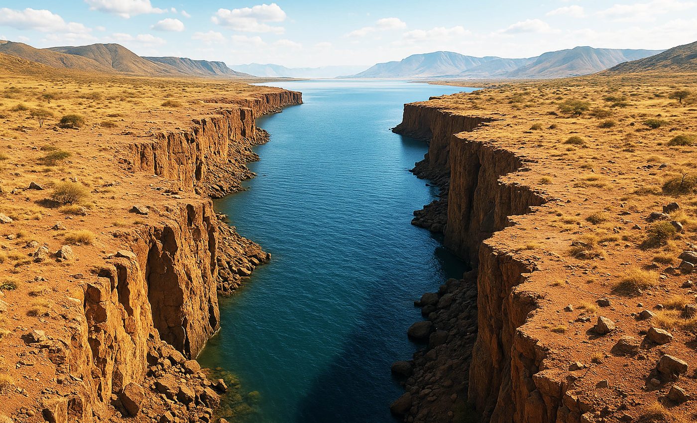
These shifts trace a long, snaking scar known as the East African Rift, which now runs about 2,000 miles from the Red Sea to central Mozambique.

The latest three‑dimensional seismic models show that the split is anything but tidy.
Beneath certain valleys, the crust is already threadbare, while nearby blocks of rock remain thick and stubborn. Deep magma rises to exploit every weakness, pushing from below while gravity pulls from above.
African rift stretches 2,000 miles
“What we do not know is if this rifting will continue on its present pace to eventually open up an ocean basin, like the Red Sea, and then later to something much larger, like a small version of the Atlantic Ocean,” said Ken Macdonald, a professor at the University of California, Santa Barbara (UCSB).
“Or might it speed up and get there more quickly? Or it might stall out, as the Atlantic did before it commenced to true seafloor spreading? At the present rate, a sea about the size of the current Red Sea might form in about 20‑30 million years.”
According to a February 2025 study published in the scientific journal JGR Solid Earth, the northern branch, called the Main Ethiopian Rift, narrows to a canyon flanked by steep faults that slip in bursts.
Farther south, the valley widens; seismic waves lose energy there faster than expected, marking pockets of molten rock that prop the crust open from below.
Volcanic processes at work
About 22 million years ago, the Somali and Nubian plates began to creep apart. A recent simulation argues that a rising plume of super‑heated mantle thins the overlying plate “like taffy left on a dashboard,” according to researchers.
“We confirmed previous ideas that lithospheric buoyancy forces are driving the rift, but we’re bringing new insight that anomalous deformation can happen in East Africa,” said Tahiry Rajaonarison of New Mexico Tech.
At the time, some geologists believed the rift was the beginning of a new ocean as two parts of the African continent pulled apart, but the claim was controversial.
Now, scientists from several countries have confirmed that the volcanic processes at work beneath the Ethiopian rift are nearly identical to those at the bottom of the world’s oceans, and the rift is indeed likely the beginning of a new sea.
Another study published in the journal Geophysical Research Letters, suggests that the highly active volcanic boundaries along the edges of tectonic ocean plates may suddenly break apart in large sections, instead of little by little as has been predominantly believed.
African rift cracks in real time
The first vivid and obvious clue to what was happening arrived in September 2005, when a 35‑mile fissure up to 25 feet wide ripped open in Ethiopia in just 10 days.
“Eventually this will drift apart,” Dr. James Hammond of the University of Bristol told the BBC World Service. “The sea will flood in and will start to create this new ocean.”

“It will pull apart, sink down deeper and deeper, and eventually…parts of southern Ethiopia, Somalia will drift off, create a new island, and we’ll have a smaller Africa and a very big island that floats out into the Indian Ocean.”
Heavy rain in 2018 exposed a similar crack in Kenya, forcing road closures and startling residents. Geologist David Adede, from the University of Nairobi, linked the event to the region‑wide tug‑of‑war between the two plates, showing that even everyday weather can uncover tectonic scars.
Model predicts a slowly-forming ocean
Computer models at Virginia Tech lend weight to the plume‑driven theory.
“If you hit Silly Putty with a hammer, it can actually crack and break. But if you slowly pull it apart, the Silly Putty stretches. So on different time scales, Earth’s lithosphere behaves in different ways,” explained Virginia Tech’s D. Sarah Stamps.
Her team’s work points toward a future ocean spreading along the current rift line. Africa will not tear completely for at least another five million years, but the groundwork is happening fast enough for satellites to watch.
“This work is a breakthrough in our understanding of continental rifting leading to the creation of new ocean basins. For the first time they demonstrate that activity on one rift segment can trigger a major episode of magma injection and associated deformation on a neighboring segment,” noted Ken Macdonald of UCSB.
“Careful study of the 2005 mega‑dike intrusion and its aftermath will continue to provide extraordinary opportunities for learning about continental rifts and mid‑ocean ridges,” Macdonald concluded.
Current hazards caused by the African rift
“In addition, such sudden large-scale events on land pose a much more serious hazard to populations living near the rift than several smaller events would,” said Cindy Ebinger, professor of earth and environmental sciences at the University of Rochester.
Rapid injections of magma can shove the surface upward, fracture highways, and rattle towns with earthquakes.
Another threat lurks in the Afar Depression, parts of which already lie below sea level. Only a 65‑foot‑high ridge in Eritrea blocks the Red Sea. If that barrier fails, seawater will surge inland long before full‑fledged seafloor spreading begins.
Ocean laboratory above ground
The Afar region and Iceland are the planet’s only places where a mid‑ocean‑ridge system stands above water.
“The whole point of this study is to learn whether what is happening in Ethiopia is like what is happening at the bottom of the ocean where it’s almost impossible for us to go,” said Ebinger.

“We knew that if we could establish that, then Ethiopia would essentially be a unique and superb ocean‑ridge laboratory for us. Because of the unprecedented cross‑border collaboration behind this research, we now know that the answer is yes, it is analogous.”
Instruments now blanket the desert, logging every shuffle of the ground and every whisper of magma. The data will refine forecasts for future continental breakups and help geologists understand how today’s oceans first opened.
Global impact of the African Rift System
To sum it all up, geologic change does move at such a slow pace it makes skyscraper construction seem fleeting, yet the sum of tiny annual motions adds up. It causes hazards that can be felt and seen during our lifetimes, while also redrawing maps.
Rarely do we get to see geological processes in action, but in this instance, we are the lucky ones. From the sudden 2005 fissure to today’s steady one‑inch‑per‑year drift, the African Rift System offers a rare front‑row seat to continental breakup in action.
Whether this continental rip stalls, accelerates, or marches on unchanged, one fact remains: the ground beneath East Africa is restless, and each year of careful observation brings scientists one step closer to explaining how whole oceans are born.
The full study was published in the journal JGR Solid Earth.
An earlier study with images was published in the journal JGR Solid Earth (Images of the rift found here).
—–
Like what you read? Subscribe to our newsletter for engaging articles, exclusive content, and the latest updates.
Check us out on EarthSnap, a free app brought to you by Eric Ralls and Earth.com.
—–


