Largest lost city in North America was bigger than London
Cahokia rose near today’s St. Louis and stretched across about 6 square miles, with a skyline made of earth. At its height between 1050 and 1200, it rivaled the size and pull of Europe’s biggest cities.
People there built more than one hundred mounds, led ceremonies, and tracked the sun with wooden posts set with care.

They belonged to the Mississippian, a farming culture that spread through the Mississippi Valley, and they turned soil and timber into a planned city.
Ancient city of Cahokia
This work was led by Timothy R. Pauketat, an archaeologist at the University of Illinois Urbana-Champaign. His research focuses on Mississippian cities, power, and religious life.
The city of Cahokia once covered roughly 6 square miles, held at least 120 mounds, and supported about 10,000 to 20,000 people at its peak. Those figures place it alongside leading medieval European cities in population for its time.
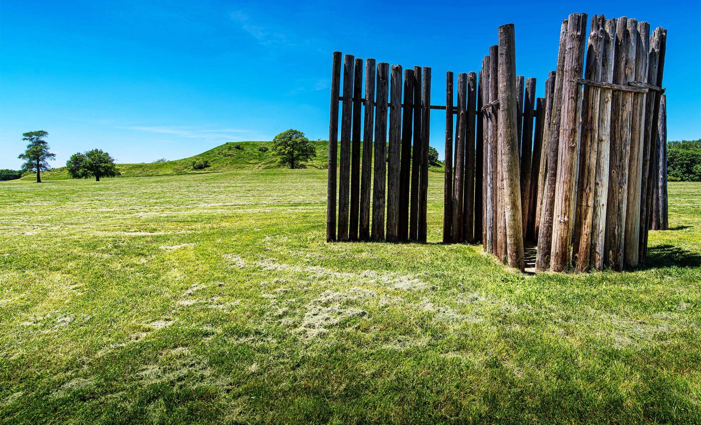
Archaeologists describe a complex chiefdom, a society led by ranked families and a central leader, organized around broad plazas. A wooden wall enclosed the core, marking space and concentrating ritual and political life.
A palisade, a tall defensive wall of logs, once ran for about 2 miles and required tens of thousands of posts. Building that barrier, refreshing it, and policing its gates took planning, labor, and steady leadership.
Earthen pyramids and a skyline
Monks Mound dominated the center of Cahokia city, standing about 100 feet tall with four stacked terraces. Its base covered acres and supported a large building, likely the place of a paramount chief or a major temple.
The mound’s sheer volume reflects years of earthmoving by hand. Workers hauled basket loads, shaped the slopes, and tiled surfaces with clay to hold the form.
The grand plaza at its foot was a civic stage. Crowds gathered for speeches, feasts, games, and rituals that displayed status and stitched neighborhoods together.
Those scenes unfolded within sight of dozens of platform mounds. Each platform likely carried buildings that housed councils, stored tribute, or framed sacred fires.
Wooden clock that tracked the sun
West of Monks Mound stood circles of red cedar posts often called Woodhenge. Excavations recorded a circle with a radius near 205 feet and posts that point to sunrise on the equinoxes and solstices.
Measured post positions show the alignments are real and deliberate. “The possibility that the alignments are not intentional but are instead the products of chance is examined but not supported,” said Michael W. Friedlander, a physicist who analyzed the survey data.
Stonehenge is also aligned to solstice events, with its axis framing the summer sunrise and winter sunset, as the site’s stewards note. That shared focus on the year’s turning points makes the comparison plain.
The solstice would have been easy to mark from those posts. A watcher at the center could track the sun’s first light across keyed horizons with consistent seasonal timing.
The posts also created a public schedule. When the sun rose in a marked notch, leaders could start festivals, planting, or redistribution, tying time to civic order.
Moon, water, and landscaping
Cahokia’s design did not stop with the sun. Research on the Emerald Acropolis, a precinct east of the core, indicates buildings and mounds followed lunar lines and processional routes that led back toward the city.
This argument rests on mapping, excavation, and repeated orientations that match lunar extremes. A 2017 study links lunar sightlines and water features to the city’s rise.
Shrines there were sometimes “closed” with silt and fire. The act sealed structures and likely marked endings or transitions in ritual time.
Those closures used water-washed sediments, not random fill. The choice suggests a cosmology that tied earth, sky, and rivers to duties of leaders and communities.
Hard truths about Cahokia city
South of the center, Mound 72 holds layered burials from about 1050 to 1150. Archaeologists have documented more than 270 individuals and clear signs that some were killed as sacrifices.
A 2016 reevaluation reassessed the famous Beaded Burial and the sequence of events at the mound. The results point to multiple episodes and complex ritual staging, not a single mass event.
Ritual authority at Cahokia could be severe. That severity, made public, also worked as a political message.
The mound’s plan shows intent and choreography. Processions, sequences, and separations reveal rules for who came close to power and who did not.
Food, climate, and staying power
Cahokia thrived during a warm, wet interval that helped maize farming. Even so, new soil evidence shows the city’s decline was not a simple climate story.
A 2024 carbon isotope analysis of paleosols, ancient buried soils, found no shift that would signal prairie takeover after a drought in the late 1200s. Fields, storage, and broad diets likely buffered people from short downturns.
The city’s food system reached beyond the floodplain. Farmers worked upland plots, fishers used rivers, and hunters drew protein from woods and wetlands.
Civic storage added resilience. Granaries evened out good and bad harvests, and timing rituals helped coordinate labor and sharing.
Lessons from the city of Cahokia
Much of greater Cahokia city lies under later roads and buildings. Even so, the core survives as an Illinois state historic site with protections, research, and public programs.
Excavations, mapping, and conservation continue to reveal details of construction and planning. The World Heritage listing notes the authenticity of major features, including Monks Mound, the palisade line, and the Woodhenge footprint.
Care now must match the care of the past. Erosion, development, and flooding remain threats that demand steady funding and smart land use.
Cahokia shows how people organized land, time, and belief without writing. Its scale, engineering, and sky knowledge still challenge what many assume about early cities in North America.
—–
Like what you read? Subscribe to our newsletter for engaging articles, exclusive content, and the latest updates.
Check us out on EarthSnap, a free app brought to you by Eric Ralls and Earth.com.
—–


