Satellites track Hurricane Melissa’s terrifying power from space
Today’s Image of the Day from the European Space Agency features a powerful view of Hurricane Melissa.
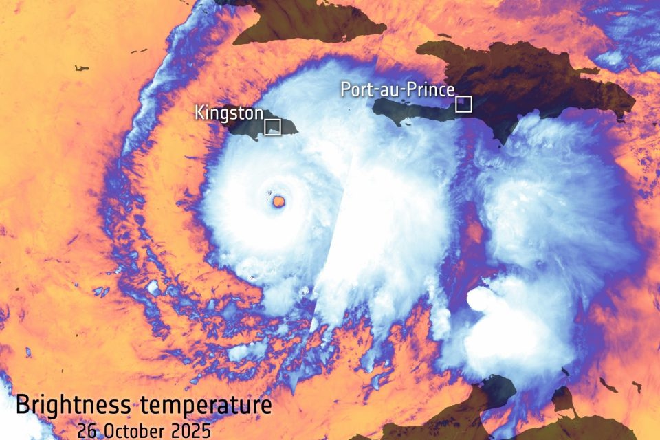
The image was captured by the Copernicus Sentinel-3 satellite on October 26, 2025, as the storm churned across the Caribbean Sea toward Jamaica.
The strongest storm of the year
The image shows what’s known as the “brightness temperature” at the top of the hurricane’s swirling clouds – a measure that reveals how hot or cold the storm appears from space.
At its center, temperatures plunge to nearly -75°C, while the outer bands hover closer to -25°C. Far below, the Caribbean waters remain warm at about 25°C, fueling the hurricane’s intensity.
The contrast between these extremes highlights the immense energy that drives a Category 5 storm – the highest level on the Saffir-Simpson scale.
The Copernicus satellite image also illustrates why Melissa is the world’s strongest storm so far this year.
Impacts of Hurricane Melissa
Across Jamaica the storm has caused sweeping destruction. The hurricane made landfall with winds reaching 185 mph and a central pressure of 892 millibars, making it the strongest ever recorded to hit the island.
In the parish of St. Elizabeth, floodwaters submerged entire communities. According to local authorities, the parish is under water.
Infrastructure damage is extensive: power outages have affected more than 540,000 customers, hospitals and roads are damaged, and landslides and fallen trees are blocking access to some areas.
The storm’s effects are spilling beyond Jamaica into neighboring nations. In Cuba and Haiti, heavy rain bands and storm surge are causing flooding, landslides and displacement of residents even before the full force of the storm arrives.
Humanitarian responses are already mobilizing. Agencies like the World Food Programme are coordinating relief supplies, cash support and logistics across the region to assist those affected by the worsening conditions.
Satellite’s eye on Hurricane Melissa
From hundreds of miles above Earth, satellites like Sentinel-3 are the only way to fully monitor hurricanes as they form, strengthen, and move across oceans.
Their sensors track details that aircraft and ground observers simply can’t reach – such as cloud-top temperatures, wind speeds, and moisture levels across vast areas.
These real-time observations help scientists model a storm’s behavior and predict where it will strike next.
The visual data also guide emergency officials on the ground, who rely on the latest satellite updates to prepare communities in the storm’s path.
Coordinating disaster response
In the case of Hurricane Melissa, both the International Charter “Space & Major Disasters” and the Copernicus Emergency Mapping Service have been activated.
These international systems combine satellite information from multiple agencies to assist governments and rescue teams when natural disasters occur.
They produce maps that show the extent of flooding, damaged infrastructure, and changing coastlines – information that can be lifesaving in the hours and days following landfall.
The data are shared freely with humanitarian groups and local authorities, allowing for faster, better-coordinated responses.
The science behind brightness temperature
Brightness temperature may sound technical, but it’s a simple concept: it’s the temperature an object would need to have to emit the same amount of radiation detected by a satellite sensor.
In a storm like Melissa, very cold cloud tops indicate powerful convection – the rising and cooling of moist air that fuels hurricanes.
When the top of the storm reaches such low temperatures, it signals a towering system with strong updrafts and intense rainfall below.
Monitoring those temperature patterns helps forecasters estimate how a storm is evolving and whether it’s likely to strengthen or weaken.
A reminder of our warming world
Hurricane Melissa is part of a troubling pattern. Warmer oceans, a result of human-driven climate change, are feeding more intense and longer-lasting tropical storms around the globe.
Warmer water provides more energy to developing systems, while higher sea levels worsen storm surges and coastal flooding.
Although it’s impossible to link any single hurricane directly to climate change, the overall trend is clear. Storms like Melissa are becoming stronger and more destructive.
That’s why accurate, continuous satellite monitoring is more important than ever – not only to protect lives but to understand how our planet is changing.
Image Credit: European Space Agency/ Copernicus data
—–
Like what you read? Subscribe to our newsletter for engaging articles, exclusive content, and the latest updates.
Check us out on EarthSnap, a free app brought to you by Eric Ralls and Earth.com.
—–


