Typhoon Sinlaku
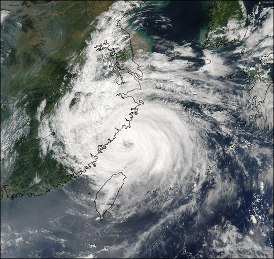
Typhoon Sinlaku After tearing through the Okinawan island chain and Taiwan late last week, Typhoon Sinlaku slammed into China this weekend, causing as many as 26 deaths and $100 million in destruction. The typhoon can be seen making landfall over China in this true-color image taken on September 7, 2002, by the Moderate Resolution Imaging Spectroradiometer (MODIS), flying aboard NASA?s Aqua spacecraft. When the typhoon hit China, it was packing winds of up to 87 miles (144 kilometers) per hour. The typhoon destroyed over a quarter of a million acres of cropland, collapsed tens of thousands of buildings, and forced hundreds of thousands from their homes. More than 1,500 people have been killed this year in China as a result of flooding and severe storms.
Please note that the high resolution image provided here is 500 meters per pixel. Visit the MODIS Rapidfire Image Gallery to obtain a copy at the sensor’s highest resolution (250 m).
Typhoon Sinlaku, known in the Philippines as Typhoon Marce, was a typhoon which affected the Philippines, Taiwan, China and Japan. It was recognised as the 13th named storm and the ninth typhoon of the 2008 Pacific typhoon season by the Japan Meteorological Agency.
The name Sinlaku was one of the ten original names submitted to the WMOs Typhoon Committee for use from January 1, 2000 by Micronesia. It was last used in the 2002 Pacific typhoon season to name a tropical storm and is the name of a goddess worshipped on the island of Kosrae in Micronesia. Note that the name is apparently shortened (a seemingly routine practice of making names easier to read to Westerners) from the original “Sin Laku
Credit: Image courtesy Jacques Descloitres, MODIS Land Rapid Response Team at NASA GSFC


News coming your way
