Dust Storm in Northern Mexico

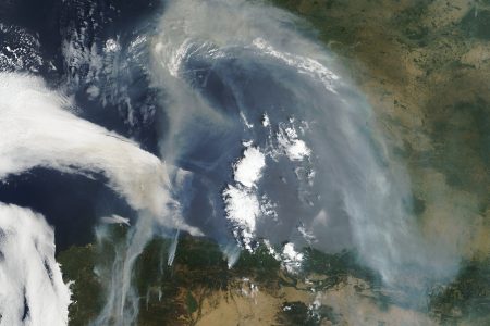
Dust Storm in Northern Mexico. On December 30, 2010, a dust storm blew from northern Mexico across the borders of Texas and New Mexico, skirting the cities of El Paso and Juarez. The Moderate Resolution Imaging Spectroradiometer (MODIS) on NASA’s Aqua satellite took this picture the same day.
This part of northern Mexico is dotted with dry salt lakes and small sand seas, providing ample material for dust storms. Multiple source points—looking like tiny pinpoints of beige fanning out toward the northeast—appear in the lower left quadrant of the image. Clouds float overhead, casting shadows onto the dust plumes below.
Northern Mexico , commonly referred as El Norte, is an informal term for the northern cultural and geographical area in Mexico. Depending on the source, it contains some or all of the states of Baja California, Baja California Sur, Chihuahua, Coahuila, Durango, Nuevo León, Sinaloa, Sonora and Tamaulipas.
In fact there is not a border that separates the northern states from the southern states in Mexico. For some authors, only states that have a border with the US are considered as northern Mexico, i.e. Baja California, Chihuahua, Coahuila, Nuevo León, Sonora and Tamaulipas.[1] Others also include Durango, Sinaloa and Baja California Sur.[2] Other people consider that the north starts above the Tropic of Cancer,[3] but this description would include some parts of Zacatecas and San Luis Potosí that are usually not considered northern states
Credit: NASA image courtesy Jeff Schmaltz, MODIS Rapid Response Team at NASA GSFC. Caption by Michon Scott.


News coming your way
