Fires in British Columbia

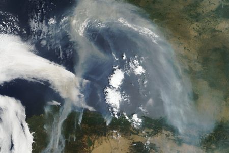
A large fire in western British Columbia was spilling smoke down over the glacier-covered slopes of the Coast Range Mountains on July 28, 2004. In the deeply carved valleys between the white-capped peaks, turquoise rivers thick with finely ground glacial sediment flow out to the Pacific Ocean through the narrow gap between Vancouver Island (bottom left) and mainland Canada. The Moderate Resolution Imaging Spectroradiometer (MODIS) on NASA’s Aqua satellite captured this image, and the places where the sensor detected actively burning fires are outlined in red.
The high-resolution image provided above is 250 meters per pixel. The MODIS Rapid Response System provides this image at additional resolutions.
The first British settlement in the area was Fort Victoria, established in 1843, which gave rise to the City of Victoria, at first the capital of the separate Colony of Vancouver Island. Subsequently, on the mainland, the Colony of British Columbia (1858–1866) was founded by Richard Clement Moody and the Royal Engineers, Columbia Detachment, in response to the Fraser Canyon Gold Rush. Moody was Chief Commissioner of Lands and Works for the Colony and the first Lieutenant Governor of British Columbia: he was hand-picked by the Colonial Office in London to transform British Columbia into the British Empire’s “bulwark in the farthest west”, and “to found a second England on the shores of the Pacific”. Moody selected the site for and founded the original capital of British Columbia, New Westminster, established the Cariboo Road and Stanley Park, and designed the first version of the Coat of arms of British Columbia. Port Moody is named after him
Credit: Image courtesy Jeff Schmaltz, MODIS Rapid Response Team, NASA-GSFC


News coming your way
