Typhoon Tingting Over the Mariana Islands

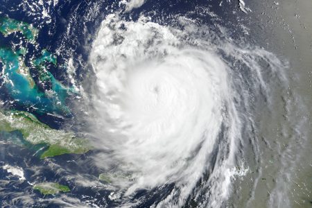
Typhoon Tingting Over the Mariana Islands. The Moderate Resolution Imaging Spectroradiometer (MODIS) onboard NASA’s Aqua satellite captured this true-color image of Typhoon Tingting on June 29, 2004 at 3:45 UTC. At that time, Tingting was located approximately 345 miles south-southeast of Iwo Jima and was packing sustained winds of 92 miles per hour with higher gusts to 115 miles per hour. The storm was forecast to strengthen and continue on a west-northwest path.
The Mariana Islands (/ˌmæriˈɑːnə/; also the Marianas; in Chamorro: Manislan Mariånas) are a crescent-shaped archipelago comprising the summits of fifteen mostly dormant volcanic mountains in the western North Pacific Ocean, between the 12th and 21st parallels north and along the 145th meridian east. They lie south-southeast of Japan, west-southwest of Hawaii, north of New Guinea and east of the Philippines, demarcating the Philippine Sea’s eastern limit. They are found in the northern part of the western Oceanic sub-region of Micronesia, and are politically divided into two jurisdictions of the United States: the Commonwealth of the Northern Mariana Islands and, at the southern end of the chain, the territory of Guam. The islands were named after the influential Spanish queen Mariana of Austria following their colonization in the 17th century.
The indigenous inhabitants are the Chamorro people. Archaeologists in 2013 reported findings which indicated that the people who first settled the Marianas arrived there after making what may have been at the time the longest uninterrupted ocean voyage in human history. They further reported findings which suggested that Tinian is likely to have been the first island in Oceania to have been settled by humans.
Credit: Jeff Schmaltz, MODIS Rapid Response Team, NASA/GSFC


News coming your way
