Satellites capture an incredibly massive Saharan dust storm crossing the Atlantic Ocean
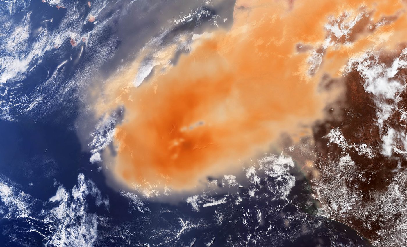
On May 7, 2025, satellites spotted something huge. A dense plume of Saharan dust blew off the west coast of Africa. It stretched across the Atlantic Ocean, covering about 150,000 square kilometers (57,915 square miles).
The Copernicus Sentinel-3 satellite took an optical image. The plume appeared as a thick, orange cloud. In the top left corner, the Cabo Verde islands peeked through the dust.

Another satellite, Sentinel-5P, added more detail. It showed aerosol levels inside the dust cloud. Darker orange indicated higher concentration. Scientists used this data to study the size and strength of the storm.
How Saharan dust rises and spreads
Saharan dust storms happen often because the desert is hot, dry, and has very loose sand. When strong surface winds blow across the ground, they pick up the fine sand and dust.
These particles don’t just stay close to the ground. If the winds are strong enough and conditions are dry, the dust gets pushed high up into the atmosphere.
Once it reaches those higher altitudes, it can ride fast-moving winds called trade winds or jet streams. These upper-level winds carry the dust across continents and even oceans. That’s how the dust sometimes reaches places as far away as the Americas.
This entire process creates what’s known as the Saharan Air Layer – a dry, dusty air mass that forms above the Atlantic Ocean. It usually develops between late spring and early autumn, when weather conditions are just right.
Some Saharan dust storms travel quickly and fade in a few days. Others can linger in the atmosphere for weeks, spreading across large areas.
What the satellites tell us
Together, Sentinel-3 and Sentinel-5P give a fuller picture. Sentinel-3 captures how the dust looks and Sentinel-5P reveals what it contains.
“Sentinel-5P is an important tool to monitor air pollution,” said European Space Agency (ESA) scientists. “It helps us understand how airborne particles affect people and ecosystems.”

The Sentinel-5P satellite carries an instrument called Tropomi, which measures gases and aerosols. It’s accurate enough to detect even small changes in air quality. This helps researchers and weather agencies stay alert.
How Saharan dust affects air quality
When these storms move over land, they affect the air people breathe. The particles hang in the air and create haze. Visibility drops. Local weather stations often issue health warnings.
Breathing dust can cause problems. It may trigger asthma, irritate lungs, or worsen heart conditions. Even people far from the desert feel the impact. These storms can reach Europe, the Caribbean, or the Americas.
Forecasting the dust’s path
Scientists use this data to build air quality models that estimate how the dust will move. The models help track when the dust will arrive, how thick it will be, and when it will clear.
The Copernicus Atmosphere Monitoring Service relies on this kind of input. It helps provide daily updates and long-range forecasts. Governments and cities use these forecasts to warn the public.
Saharan dust may help the environment
Dust storms do more than just cause breathing problems. They also help nature in a big way. Saharan dust isn’t just dry sand. It’s full of minerals like phosphorus and iron.
These minerals are important for life. As the dust floats across the Atlantic Ocean, some of it falls into the water.

When that happens, the minerals act like fertilizer. They help phytoplankton in the ocean to grow.
Phytoplankton form the base of the ocean food chain. Fish, whales, and many sea animals rely on them to survive. So while dust storms may look like a threat, they also help feed life far from the desert.
Saharan dust feeds the Amazon rainforest
Some of the dust makes it even farther – to the Amazon rainforest. That dust fertilizes the soil. It brings in nutrients that the forest needs but can’t get easily from local sources.
The Sahara sends out these massive plumes each year. With modern satellites, we can now watch them form, grow, and move. The images help us understand both the risks and the benefits.
Dust clouds from the Sahara may cause air quality alerts, but they also feed the ocean and the forest. They cross continents, link ecosystems, and remind us that weather and climate don’t stop at borders.
Click here to compare the images from each satellite.
—–
Like what you read? Subscribe to our newsletter for engaging articles, exclusive content, and the latest updates.
Check us out on EarthSnap, a free app brought to you by Eric Ralls and Earth.com.
—–


