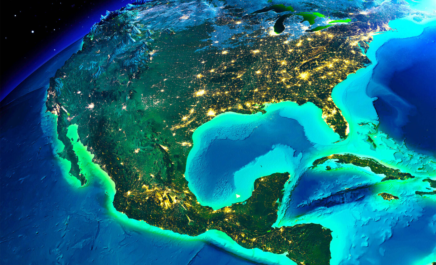
The U.S. just expanded its territory by one million square kilometers
In a historic move, the United States has officially expanded its geographical territory by one million square kilometers — an area nearly 60 percent the size of Alaska. The catalyst for this territory expansion lies in the redefinition of the U.S. continental shelf boundaries.
By invoking international law, the State Department has outlined new areas under the sea where the continental shelf, a seabed area surrounding large landmasses with relatively shallow waters, extends further than previously recognized.

This monumental addition is spread across seven distinct ocean regions, with over half of the new territory located in the Arctic.
Extended Continental Shelf (ECS)
The concept of the Extended Continental Shelf (ECS) is pivotal in understanding this expansion.
Under international law, coastal nations can claim these extended shelves, along with the right to manage and exploit their resources.
With this territory expansion move, the U.S. joins over 75 countries that have defined their ECS limits, which extend beyond 200 nautical miles from their coasts.
The journey to this announcement began in 2003, involving a multi-agency collaboration led by the U.S. State Department, NOAA, and the U.S. Geological Survey.
The mission was to gather comprehensive geological data to determine the outer limits of the U.S. continental shelf.
This extensive effort ended on December 19, 2023, with the State Department revealing the new geographic coordinates that mark the U.S. ECS.
U.S. territory expansion and marine resources
The areas encompassed in this claim include the Arctic, the east coast Atlantic, the Bering Sea, the west coast Pacific, the Mariana Islands, and two regions in the Gulf of Mexico.
The addition of this vast territory, equivalent in size to double the state of California, significantly strengthens the nation’s control over marine resources.
“America is larger than it was yesterday,” said Mead Treadwell, a former Alaska lieutenant governor and former chair of the U.S. Arctic Research Commission.
“It’s not quite the Louisiana Purchase. It’s not quite the purchase of Alaska, but the new area of land and subsurface resources under the land controlled by the United States is two Californias larger.”
State Department project director Brian Van Pay said it took multi-agency fieldwork spanning 20 years for scientists to gather data about the shape of the seafloor and measuring sediment layers.
“Forty missions at sea, going to areas that we’ve never explored before, finding entire seamounts we didn’t even know existed,” said Van Pay.
“And, if you add up all the time that our scientists spent at sea, it’s over three years of data collection.”
Strong scientific foundation
This claim, although unratified by the U.S. Senate, adheres to the 1982 United Nations Convention on the Law of the Sea.
Despite the lack of formal ratification, the U.S. government proceeded to announce its continental shelf limits.
Treadwell asserted confidence in the scientific foundation of this unilateral move.
“If somebody came back and said, ‘Your science is bad,’ I think the United States would listen. But I don’t think science is bad. I think we’ve had very good science,” said Treadwell.
The State Department’s Arctic claim notably aligns with a 1990 maritime boundary agreement with Russia, ensuring no encroachment on Russian territory.
“None of the fixed points delineating the outer limits of the continental shelf of the United States are located west of the agreed boundary with the Russian Federation,” said the State Department.
However, potential overlap with Canada’s claims was acknowledged by Van Pay, indicating future diplomatic negotiations.
Mining and research rights of U.S. territory expansion
Crucially, this declaration does not extend U.S. jurisdiction over the water column or fishing rights beyond 200 miles off its coast.
Instead, it focuses on control over the seabed and its resources, including mining and research rights, as well as pipeline activities.
The extended continental shelf areas include portions of the Atlantic, Pacific, the Gulf of Mexico, and the Mariana Islands.
The largest section lies north of Alaska, coupled with a smaller segment in the Bering Sea, collectively nearing the size of Texas.
More about the Extended Continental Shelf
As discussed above, the concept of the Extended Continental Shelf (ECS) is pivotal in the realm of international maritime law and geopolitics.
It represents an area of the seabed and subsoil that stretches beyond a nation’s 200 nautical miles exclusive economic zone (EEZ).
Legal framework for U.S. territory expansion
The United Nations Convention on the Law of the Sea (UNCLOS) serves as the cornerstone for the legal definition and governance of the ECS.
Under this framework, coastal states can claim an ECS up to 350 nautical miles from their baseline or 100 nautical miles from the 2,500-meter isobath, which is a line connecting depths of 2,500 meters.
Key Provisions
- Article 76 of UNCLOS: This article provides the legal basis for the extension of the continental shelf beyond the 200 nautical miles. It outlines specific criteria and methods for determining the outer limits of the continental shelf.
- Commission on the Limits of the Continental Shelf (CLCS): Established under UNCLOS, this body evaluates the submissions made by coastal states regarding the outer limits of their continental shelf.
Process of claiming ECS
Claiming an ECS is a meticulous and scientific process. Coastal states must submit detailed geological and hydrographic data supporting their claim to the CLCS.
- Data Collection: States conduct extensive seabed surveys to collect geophysical and hydrographic data.
- Preparation of Submission: The collected data is then used to prepare a submission that delineates the outer limits of the continental shelf.
- Evaluation by CLCS: The CLCS reviews the submission and makes recommendations. These are not binding but carry significant legal weight.
Significance of the ECS
- Resource Management: The ECS is rich in resources like oil, gas, and minerals. Sovereign rights over these resources are vital for economic development.
- Environmental Protection: Jurisdiction over the ECS enables states to enforce environmental regulations, safeguarding marine ecosystems.
- Geopolitical Relevance: The ECS can have strategic importance, affecting maritime boundaries and regional stability.
Challenges and controversies
- Overlapping Claims: In regions where the continental shelves of neighboring countries overlap, there is potential for disputes.
- Technical and Financial Constraints: The process of delineating the ECS is resource-intensive, posing challenges for smaller or less developed countries.
- Environmental Concerns: Exploitation of resources in the ECS must balance economic interests with environmental protection.
In summary, the Extended Continental Shelf is a complex yet crucial aspect of maritime law and geopolitics. It presents opportunities and challenges for coastal states.
As nations navigate these waters, it is imperative that they adhere to the principles of international law, promote cooperation, and balance economic aspirations with environmental stewardship.
The stewardship of the ECS is not just a matter of national interest but a global responsibility, requiring concerted efforts to maintain the delicate balance between resource utilization and ocean conservation.
More about UNCLOS and U.S. territory expansion
As discussed above, the United Nations Convention on the Law of the Sea (UNCLOS), often referred to as the Law of the Sea Treaty, stands as a comprehensive framework that governs the world’s oceans and seas.
Established through the collective effort of more than 160 countries, UNCLOS outlines the legal guidelines for marine natural resource management, environmental protection, and the maritime rights of nations. This article delves into the origins, key provisions, and impact of UNCLOS on international maritime law.
Origins of UNCLOS
The inception of UNCLOS dates back to the 20th century, when the increasing exploitation of marine resources and advancements in maritime technology necessitated a comprehensive set of international rules.
The convention emerged from three United Nations conferences on the Law of the Sea, with the first taking place in 1956. However, it was not until 1982 that the treaty was finalized, and it officially came into effect on November 16, 1994.
Key provisions of UNCLOS
UNCLOS encompasses a broad range of maritime issues, from territorial waters to the deep seabed. Here are some of its key provisions:
Territorial sea and contiguous zone
UNCLOS allows coastal states to claim a territorial sea up to 12 nautical miles from their baseline, where they exercise sovereignty. Beyond this, up to 24 nautical miles from the baseline, lies the contiguous zone, where a state can enforce laws concerning customs, taxation, immigration, and pollution.
Exclusive Economic Zone (EEZ)
One of the most significant contributions of UNCLOS is the establishment of the Exclusive Economic Zone (EEZ), extending up to 200 nautical miles from the baseline. Within this zone, coastal states have exclusive rights to exploit natural resources, both in the water and the seabed.
Continental shelf
UNCLOS defines the continental shelf of a coastal state as extending to the outer edge of the continental margin or 200 nautical miles from the baseline, whichever is greater. States have the right to harvest mineral and non-living resources from the seabed of their continental shelf.
High seas
The high seas are open to all states, whether coastal or land-locked, and are beyond any national jurisdiction. UNCLOS ensures freedom of navigation, overflight, fishing, and scientific research on the high seas.
Protection of the marine environment
UNCLOS also addresses the protection and preservation of the marine environment. It obligates states to prevent, reduce, and control pollution of the marine environment from any source.
Dispute resolution
The convention includes mechanisms for the peaceful resolution of disputes between states concerning the interpretation or application of its provisions.
Impact of UNCLOS
Since its adoption, UNCLOS has profoundly influenced international maritime law. It has facilitated the peaceful use of the seas and oceans, promoted equitable and efficient utilization of their resources, and protected the marine environment. The treaty has also provided a framework for resolving maritime disputes, thus contributing to global stability and peace.
However, challenges remain, including disputes over territorial claims, enforcement of environmental regulations, and piracy. Despite these challenges, UNCLOS continues to serve as the “Constitution for the Oceans,” guiding the international community in the management and conservation of ocean resources.
In summary, the United Nations Convention on the Law of the Sea represents a pivotal achievement in international law, embodying a collective commitment to the peaceful, equitable, and sustainable use of the world’s oceans.
As humanity faces new maritime challenges, UNCLOS will undoubtedly play a crucial role in navigating these waters, ensuring that the oceans remain a source of life and prosperity for future generations.
—–
Like what you read? Subscribe to our newsletter for engaging articles, exclusive content, and the latest updates.
—–
Check us out on EarthSnap, a free app brought to you by Eric Ralls and Earth.com.
—–


