Antarctic sea ice hits one of its lowest winter peaks on record
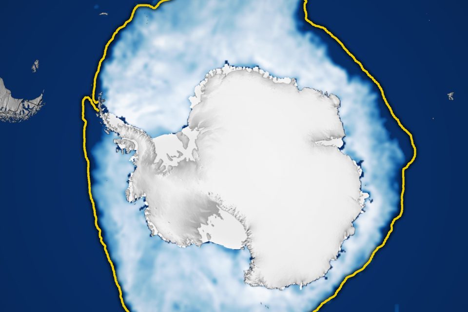
Today’s Image of the Day from NASA Earth Observatory features a sweeping view of Antarctic sea ice as it reached its annual winter peak in mid-September.
The bright expanse of ice stands out sharply against the deep blue of the Southern Ocean. Yet even at its widest reach, the frozen cover remained smaller than what long-term records would normally suggest.
The scene captures a moment in a year that left scientists with more questions than answers about the future of this remote and important part of the planet.
An alarming discovery
Every winter, the Southern Hemisphere cools and sea ice spreads outward from Antarctica. The ice grows as frigid winds push surface water to the freezing point.
When the season reaches its height, the frozen cover typically blankets millions of square miles of ocean. But this winter’s maximum showed a notable shortfall.
On September 17, the ice reached 6.88 million square miles, well below where it used to stand before 2016.
That gap has kept researchers on alert, because the frozen edge of the Antarctic acts as a natural buffer that shapes ocean circulation, supports ecosystems, and influences weather patterns thousands of miles away.
A shrinking winter peak
The new numbers place this year’s maximum as the third-lowest in the 47-year satellite record. Compared to the 1981–2010 average, the difference is about 348,000 square miles.
The sea ice retreat is visible in the NASA image. The white area that marks the current extent sits noticeably inside the yellow outline that represents the long-term norm for the same day.
The shift is more than a statistical blip. It signals a pattern that has emerged over the past several years, with winters that no longer match the larger peaks documented in earlier decades.
Measuring Antarctic sea ice
The measurements come from teams at NASA and the National Snow and Ice Data Center (NSIDC), where researchers track the edge of the ice daily. They divide the ocean into a grid and add up the area of squares that meet the threshold for sea ice.
A square needs to be at least 15 percent ice-covered before it counts toward the total – a method that provides a consistent way to compare year after year.
These steady yardsticks help scientists make sense of a region that can change from day to day due to winds, currents, and storms.
A system that keeps us guessing
Sea ice around Antarctica behaves differently than sea ice in the Arctic, and that difference makes it harder to read the signs.
The Southern Ocean is constantly stirred by strong winds and powerful currents that push the ice around. Those movements can cause sudden expansions or retreats that are not tied to temperature alone.
Nathan Kurtz, chief of the Cryospheric Sciences Laboratory at NASA’s Goddard Space Flight Center, said the Antarctic system’s complexity makes it challenging to predict and understand these trends.
The past decade has shown sharp swings between high and low peaks. Before 2016, scientists saw several winters reach record or near-record highs. Since then, the pattern flipped, with a string of years that fell well below what was expected.
These rapid shifts add another hurdle, because they raise the possibility that the system may be entering a new state. The data now prompt fresh questions about what is driving the lower peaks and whether broader climate conditions are at play.
Watching the trends unfold
The coming years will help clarify whether this trend becomes a fixture or fades with time.
“For now, we’re keeping an eye on it,” said NSIDC scientist Walt Meier. He noted that it is still too early to say whether the shift is permanent or simply part of a passing phase.
Meier’s cautious stance reflects how quickly conditions can change in the Southern Ocean. A strong storm season or a shift in ocean temperatures could reshape the ice edge in ways that mask or exaggerate long-term signals.
Even so, the lower maximum carries weight beyond the Antarctic Circle. Sea ice helps reflect sunlight, steady ocean temperatures, and support food webs that feed penguins, seals, and whales.
When the ice covers less area, dark water absorbs more heat. That added warmth can influence weather patterns, change habitats, and nudge the climate system in new directions.
Even though it may seem distant, the change along Antarctica’s icy edge connects to the broader story of how a warming planet responds. These shifts send signals that reach well beyond the poles, hinting at where things may be headed next.
Image Credit: NASA Earth Observatory
—–
Like what you read? Subscribe to our newsletter for engaging articles, exclusive content, and the latest updates.
Check us out on EarthSnap, a free app brought to you by Eric Ralls and Earth.com.
—–


