Fires And Smoke Across Alaska and Canada

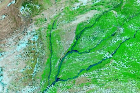
Fires And Smoke Across Alaska and Canada. When NASA’s Aqua satellite passed over eastern Alaska and western Yukon Territory, Canada, on June 29, 2004, the Moderate Resolution Imaging Spectroradiometer (MODIS) captured this awesome image of dozens of large wildfires belching huge columns of smoke as forests went up in flames. Areas where MODIS detected actively burning fires are outlined in red. A large number of the fires are burning in a region called the Yukon Flats, a vast floodplain of the northern reaches of the Yukon River. The flats are located between the Alaska Range Mountains to the south and the Brooks Range to the north, both of which are largely hidden by smoke in this scene.
Many of these fires, including the 200,000-plus-acre Solstice Complex Fire located north of the .hump. in the Yukon River, were triggered during several days of extreme lightning activity. Small-scale evacuations occurred in some small towns and villages in the region, and sections of the Alaska Highway have been closed off and on. Reports from the Alaska Fire Service on June 29 indicated there were 57 large fires burning in the state. So far this season, 327 fires have affected nearly 840,000 acres. Fires And Smoke Across Alaska and Canada. Alaska is a U.S. state on the northwest extremity of the country’s West Coast, just across the Bering Strait. A semi-exclave of the U.S., it borders the Canadian province of British Columbia and territory of Yukon to the east and southeast and has a maritime border with Russia’s Chukotka Autonomous Okrug to the west. To the north are the Chukchi and Beaufort seas of the Arctic Ocean, while the Pacific Ocean lies to the south and southwest.
Credit: Jeff Schmaltz, MODIS Rapid Response Team, NASA/GSFC


News coming your way
